View table: bridge
Table structure:
- Name - String
- Road - String
- Water - String
- City - String
- County - String
- Type - String
- Builder - String
- Length - Integer
- Height - Integer
- Built - Date
- FDOT - String
- Coordinates - Coordinates
- Description - Wikitext
- Article - Page
- Image - File
- Link1 - URL
- Link2 - URL
- Link3 - URL
- Poster - String
- Posted - String
This table has 13 rows altogether.
| Page | Name | Road | Water | City | County | Type | Builder | Length | Height | Built | FDOT | Coordinates | Description | Article | Image | Link1 | Link2 | Link3 | Poster | Posted |
|---|---|---|---|---|---|---|---|---|---|---|---|---|---|---|---|---|---|---|---|---|
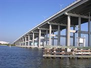
| Info:Alma Lee Loy Bridge | Alma Lee Loy Bridge | CR656 | Central Indian River | Vero Beach | Indian River | Stringer/Multi-beam | 4,731 | 62 | 1979 | 880077 | 27.63221,-80.3691 | Alma Lee Loy Bridge, commonly known as 17th Street Bridge, is a fixed concrete bridge that spans the Indian River intracoastal waterway in Indian River County, Florida. The bridge, started in 1977, was constructed by Gulf Contracting Inc, FL and completed in 1979. |
Admin | 20191203223115 | ||||||
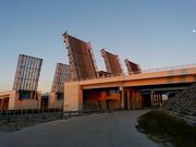
| Info:Canaveral Locks Bridge | Canaveral Locks Bridge | SR401 | Banana River | Cape Canaveral | Brevard | Bascule Triple Draw Span | 314 | 23 | 1972 | 700117 | 28.40926, -80.63248 | Located in Port Canaveral, Canaveral Locks Bridge is a set of three double leaf lift span drawbridges spanning State Road 401 from Kennedy Space Center across the Canaveral Barge Canal into Cape Canaveral. |
Canaveral Locks Bridge | Admin | 20191203092947 | |||||
| Info:Eau Gallie Causeway | Eau Gallie Causeway | SR518 | North Indian River | Melbourne | Brevard | High Span | 2,901 | 1988 | 700184 | 28.13259, -80.61798 | The Eau Gallie causeway carries Eau Gallie Blvd. (Sr518) across the North Indian River lagoon in Melbourne, Florida. |
Admin | 20210709081754 | |||||||
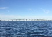
| Info:Ernest Lyons Bridge | Ernest Lyons Bridge | A1A | South Indian River | Sewell's Point | Martin | Segmental Span | Corven Engineering | 4,600 | 62 | 2008 | 890158 | 27.20644,-80.19229 | The new Ernest F. Lyons Bridge is a 4600-ft-long, 31-span, two-lane, precast segmental bridge built using the span-by-span method of construction. |
Admin | 20191203232923 | |||||
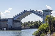
| Info:Haulover Canal Bridge | Haulover Canal Bridge | SR3 | Mosquito Lagoon | Allenhurst | Brevard | Bascule Double Leaf | McCormick and Sons | 27 | 1964 | 703004 | 28.73634,-80.75459 | 1964 U.S. Army Corps of Engineers' Bascule double leaf drawbridge crossing Florida SR3 (N Courtney Parkway) over the Haulover Canal in the Merritt Island Wildlife Refuge. |
Haulover Canal | NASA RECORD CANAVERAL AFS 1964 with HAULOVER BRIDGE PHOTOS (PDF 67pp) URL |
Admin | 20191204000204 | ||||
| Info:Mathers Bridge | Mathers Bridge | SR3 | Banana River | Indian Harbour Beach | Brevard | Metal Swing Span | Austin Bridge Co. | 792 | 2005 | 704063 | 28.1492,-80.6061 | Mathers Bridge is a 700-foot-long (210 m) low-level swing bridge located on the southern tip of Merritt Island, Florida, crossing the Banana River at the south end of State Road 3. The bridge was built in 1927 by John Mathers in order to connect Merritt Island to what is now Indian Harbour Beach, and was moved to its present location in 1952. It was constructed by the Austin Brothers Bridge Company. The bridge and the control house were rehabilitated in 2007. |
Mathers Bridge Historic Engineering Record | Admin | 20191202155425 | |||||
| Info:Max Brewer Bridge | Max Brewer Bridge | SR406 | North Indian River | Titusville | Brevard | Segmental Span | DRMP | 3,207 | 65 | 2010 | 700227 | 28.61758,-80.80274 | Completed in 2010, the 3,207' long, 65' high A. Max Brewer Bridge connects the City of Titusville to Merritt Island providing access to the Kennedy Space Center via SR406. Includes a fishing pier and boat ramps on the west side and a 20' observation deck at the crest. This bridge is a good observation site for Kennedy Space Center, when it is closed to vehicle traffic. |
Max Brewer Bridge | Admin | 20191202211317 | ||||
| Info:Merrill Barber Bridge | Merrill Barber Bridge | SR60 | Central Indian River | Vero Beach | Indian River | concrete arch | Odebrecht | 3,834 | 62 | 1995 | 880087 | 27.65293,-80.37329 | The Merrill Barber Bridge is a concrete arch bridge that spans SR60 over the Indian River in Indian River County, Florida. |
Merrill Barber Bridge | Video: Merrill P. Barber Bridge is Busiest Connection From Vero Beach to Barrier Island URL |
Admin | 20201024125120 | |||
| Info:NASA Causeway Indian River | NASA Causeway Indian River | SR405 | North Indian River | Titusville | Brevard | Bascule Drawbridge | McCormick and Sons | 2,993 | 1964 | 703001 | 28.5284, -80.76561 | Three mile long NASA Causeway connects SR405 in Titusville with Kennedy Space Center's NASA Parkway in Merritt Island, Florida. The causeway's 2,990ft bridge across the Indian River spans the Intracoastal Waterway (ICW) channel with a 142ft divided, four-lane, double-leaf bascule drawbridge. A new high span concrete bridge is due to begin construction in late 2021. |
Admin | 20210217081914 | ||||||
| Info:Pineda Causeway | Pineda Causeway | SR404 | North Indian River | Melbourne | Brevard | Concrete deck girder | Gregg, Gibson & Gregg | 2,282 | 62 | 1971 | 700143 | 28.20614,-80.65062 | Constructed in 1973 for an estimated $7m, the Pineda Causeway spans State Road 404 across both the Indian River and Banana River lagoons from Melbourne to South Patrick Shores in Brevard County, Florida. The causeway uses eight earthen berms, two high bridge spans, and 4 relief bridges to span the lagoons. |
Pineda Causeway 2.jpg | Admin | 20200906194716 | ||||
| Info:Roosevelt Bridge | Roosevelt Bridge | US1 | Saint Lucie River | Stuart | Martin | Segmental Span | Finley | 2,983 | 62 | 1996 | 890151 | 27.20672,-80.25854 | The Roosevelt Bridge is a major highway segmental bridge across the St. Lucie River in Stuart, Florida. Carrying U.S. Route 1, it was built to supersede the old Roosevelt Bridge, which had twin parallel drawbridges, one for northbound traffic and the other for southbound. |
Admin | 20191203234051 | |||||
| Info:Sebastian Inlet Bridge | Sebastian Inlet Bridge | A1A | Central Indian River | Indian River Oaks | Brevard | Segmental Span | Cleary Brothers | 1,548 | 37 | 1964 | 880005 | 27.86069, -80.44873 | The James H. Pruitt Memorial Bridge is a two lane segmental span bridge carrying A1A from Brevard County across the Sebastian Inlet to Indian River County. The first Sebastian Inlet Bridge was built in 1964 by Cleary Brothers Construction Company of West Palm Beach, Florida. Construction of a new replacement bridge will begin in 2026. |
Sebastian Inlet | Admin | 20191202223845 | ||||
| Info:Wabasso Bridge | Wabasso Bridge | SR510 | Central Indian River | Wabasso | Indian River | Concrete High Span | Scott Construction | 1,689 | 62 | 1970 | 880051, 880053 | 27.75975,-80.41797 | Wabasso Bridge is a two-lane concrete bridge spanning SR510 over the Indian River and Intracoastal Waterway in Indian River County, Florida. |
Wabasso Bridge | Admin | 20191203154329 |
