Info:Wabasso Bridge
From Indian River Lagoon Project
|
|
|
|
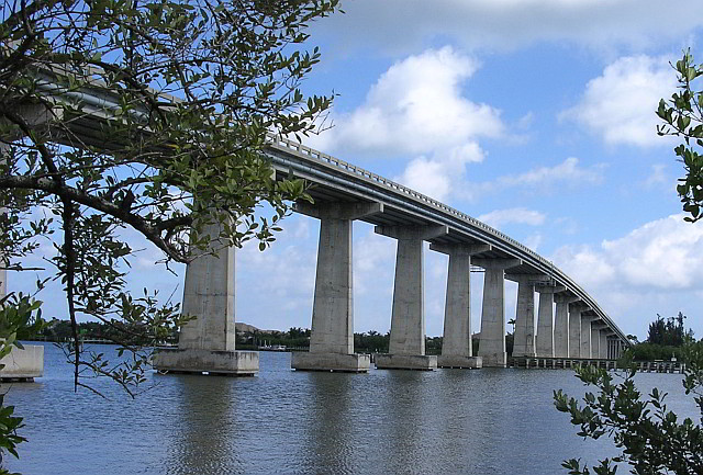
| Wabasso Bridge is a two-lane concrete bridge spanning SR510 over the Indian River and Intracoastal Waterway in Indian River County, Florida. Article
|
| Waterway: Central Indian River
|
Road: SR510
|
| City: Wabasso
|
County: Indian River
|
| Type: Concrete High Span
|
Builder:Scott Construction
|
| DOT: 880051, 880053
|
L: 1689.4'
|
H: 62.3'
|
Built: 1970
|
Location: 27.75975,-80.41797
|
Wabasso Causeway includes 4 bridges:
| Number
|
Water
|
Structure
|
Road
|
| 880052
|
Indian River
|
West Relief
|
SR510
|
National Bridge Data
| Number
|
880052
|
| Route
|
00510
|
| Place
|
74625
|
| County
|
Indian River
|
| Features
|
Indian River Relief
|
| Facility
|
SR510 Wabasso Road
|
| Location
|
0.5Mi East of US-1
|
| Latitude
|
27451178
|
| Longitude
|
80254429
|
| Service On Roadway
|
Highway - Pedestrian
|
| Service Under Roadway
|
Waterway Relief
|
| Owner
|
FDOT
|
| Built
|
1967
|
| Rebuilt
|
|
| Lanes
|
2
|
| Lane Direction
|
2 way
|
| Direction
|
|
| Traffic
|
13300
|
| Traffic Year
|
2016
|
| Future Traffic
|
23076
|
| Future Traffic Year
|
2038
|
| Length
|
61m
|
| Width
|
12m
|
| Clearance
|
|
| Kind
|
Prestressed concrete
|
| Type
|
Stringer/Multi-beam/Girder
|
| Deck Type
|
Concrete Cast-in-Place
|
| Critical
|
|
| Inspection Date (mm-yy)
|
11-17
|
| Deck
|
Good
|
| Superstructure
|
Good
|
| Substructure
|
Good
|
| Channel
|
Bank is beginning to slump. River control devices and embankment protection have widespread minor damage. There is minor stream bed movement evident. Debris is restricting the channel slightly.
|
| Culvert
|
N/A
|
| Scour
|
Bridge foundations determined to be stable for the assessed or calculated scour condition. Scour is determined to be above top of footing (Example A) by assessment (i.e., bridge foundations are on rock formations that have been determined to resist scour within the service life of the bridge4), by calculation or by installation of properly designed countermeasures
|
|
| Number
|
Water
|
Structure
|
Road
|
| 880051
|
Indian River
|
West Span
|
SR510
|
National Bridge Data
| Number
|
880051
|
| Route
|
00510
|
| Place
|
74625
|
| County
|
Indian River
|
| Features
|
Indian River
|
| Facility
|
SR-510 Wabasso Rd
|
| Location
|
0.7Mi East of US-1
|
| Latitude
|
27452066
|
| Longitude
|
80252909
|
| Service On Roadway
|
Highway - Pedestrian
|
| Service Under Roadway
|
Waterway
|
| Owner
|
FDOT
|
| Built
|
1967
|
| Rebuilt
|
|
| Lanes
|
2
|
| Lane Direction
|
2 way
|
| Direction
|
|
| Traffic
|
13300
|
| Traffic Year
|
2016
|
| Future Traffic
|
23076
|
| Future Traffic Year
|
2038
|
| Length
|
412m
|
| Width
|
12m
|
| Clearance
|
|
| Kind
|
Prestressed concrete
|
| Type
|
Stringer/Multi-beam/Girder
|
| Deck Type
|
Concrete Cast-in-Place
|
| Critical
|
|
| Inspection Date (mm-yy)
|
11-17
|
| Deck
|
Satisfactory
|
| Superstructure
|
Satisfactory
|
| Substructure
|
Satisfactory
|
| Channel
|
Bank protection is in need of minor repairs. River control devices and embankment protection have a little minor damage. Banks and/or channel have minor amounts of drift.
|
| Culvert
|
N/A
|
| Scour
|
Bridge foundations determined to be stable for the assessed or calculated scour condition. Scour is determined to be above top of footing (Example A) by assessment (i.e., bridge foundations are on rock formations that have been determined to resist scour within the service life of the bridge4), by calculation or by installation of properly designed countermeasures
|
|
| Number
|
Water
|
Structure
|
Road
|
| 880053
|
Indian River
|
East Span
|
SR510
|
National Bridge Data
| Number
|
880053
|
| Route
|
00510
|
| Place
|
74625
|
| County
|
Indian River
|
| Features
|
Intracoastal Waterway
|
| Facility
|
SR-510(Wabasso Rd)
|
| Location
|
1.4MI E OF US-1
|
| Latitude
|
27453510
|
| Longitude
|
80250470
|
| Service On Roadway
|
Highway
|
| Service Under Roadway
|
Waterway
|
| Owner
|
FDOT
|
| Built
|
1970
|
| Rebuilt
|
|
| Lanes
|
2
|
| Lane Direction
|
2 way
|
| Direction
|
|
| Traffic
|
13300
|
| Traffic Year
|
2016
|
| Future Traffic
|
23076
|
| Future Traffic Year
|
2038
|
| Length
|
515m
|
| Width
|
11m
|
| Clearance
|
|
| Kind
|
Prestressed concrete
|
| Type
|
Stringer/Multi-beam/Girder
|
| Deck Type
|
Concrete Cast-in-Place
|
| Critical
|
|
| Inspection Date (mm-yy)
|
12-17
|
| Deck
|
Satisfactory
|
| Superstructure
|
Good
|
| Substructure
|
Good
|
| Channel
|
Bank protection is in need of minor repairs. River control devices and embankment protection have a little minor damage. Banks and/or channel have minor amounts of drift.
|
| Culvert
|
N/A
|
| Scour
|
Bridge foundations determined to be stable for the assessed or calculated scour condition. Scour is determined to be above top of footing (Example A) by assessment (i.e., bridge foundations are on rock formations that have been determined to resist scour within the service life of the bridge4), by calculation or by installation of properly designed countermeasures
|
|
| Number
|
Water
|
Location
|
Road
|
| 880050
|
Indian River
|
East Relief
|
SR510
|
National Bridge Data
| Number
|
880050
|
| Route
|
00510
|
| Place
|
74625
|
| County
|
Indian River
|
| Features
|
Indian River
|
| Facility
|
SR510 Wabasso Road
|
| Location
|
1.2MI East of US-1
|
| Latitude
|
27452951
|
| Longitude
|
80251396
|
| Service On Roadway
|
Highway - Pedestrian
|
| Service Under Roadway
|
Waterway
|
| Owner
|
FDOT
|
| Built
|
1967
|
| Rebuilt
|
|
| Lanes
|
2
|
| Lane Direction
|
2 way
|
| Direction
|
|
| Traffic
|
13300
|
| Traffic Year
|
2016
|
| Future Traffic
|
23076
|
| Future Traffic Year
|
2038
|
| Length
|
61m
|
| Width
|
12m
|
| Clearance
|
|
| Kind
|
Prestressed concrete
|
| Type
|
Stringer/Multi-beam/Girder
|
| Deck Type
|
Concrete Cast-in-Place
|
| Critical
|
|
| Inspection Date (mm-yy)
|
11-17
|
| Deck
|
Good
|
| Superstructure
|
Good
|
| Substructure
|
Satisfactory
|
| Channel
|
Bank protection is in need of minor repairs. River control devices and embankment protection have a little minor damage. Banks and/or channel have minor amounts of drift.
|
| Culvert
|
N/A
|
| Scour
|
Bridge foundations determined to be stable for the assessed or calculated scour condition. Scour is determined to be above top of footing (Example A) by assessment (i.e., bridge foundations are on rock formations that have been determined to resist scour within the service life of the bridge4), by calculation or by installation of properly designed countermeasures
|
|