Wabasso Bridge
From Indian River Lagoon Project
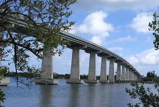
Wabasso Causeway Bridge is a 1,689.4' long, two-lane, concrete bridge spanning Bridge Blvd. (SR510) over the Indian River in Indian River County, Florida.
Built by Scott Construction Company in 1970, Wabasso Bridge has a maximum vertical clearance of 62.3 feet and it's longest span is 112.9ft.
It's Department of Transportation numbers are DOT# 880051 for the relief bridge and DOT# 880053 for the main span.
|
|
|
|
| Waterway: Central Indian River
|
Road: SR510
|
| City: Wabasso
|
County: Indian River
|
| Type: Concrete High Span
|
Builder:Scott Construction
|
| DOT: 880051, 880053
|
L: 1689'
|
H: 62'
|
Built: 1970-01-01
|
Location: (27.75975,-80.41797)
|
| Wabasso Bridge is a two-lane concrete bridge spanning SR510 over the Indian River and Intracoastal Waterway in Indian River County, Florida.
|
History
Until 1920, there were only two bridges spanning across the Indian River, one in Brevard County's Cocoa and the second in Martin County's Hobe Sound.
On Labor Day in 1920, a new wooden Vero Bridge opened and access to the ocean was available to all who lived on the Vero mainland.
The bridge tender lived in a house near the middle of the crossing and would open the metal swing span by hand for boat traffic.
Tolls were charged to cross the bridge, ranging from 5 cents for pedestrians to 10 cents for horses and 35 cents for delivery trucks.[1]
National Bridge Data
| Number
|
Water
|
Structure
|
Road
|
| 880051
|
Indian River
|
West Span
|
SR510
|
National Bridge Data
| Number
|
880051
|
| Route
|
00510
|
| Place
|
74625
|
| County
|
Indian River
|
| Features
|
Indian River
|
| Facility
|
SR-510 Wabasso Rd
|
| Location
|
0.7Mi East of US-1
|
| Latitude
|
27452066
|
| Longitude
|
80252909
|
| Service On Roadway
|
Highway - Pedestrian
|
| Service Under Roadway
|
Waterway
|
| Owner
|
FDOT
|
| Built
|
1967
|
| Rebuilt
|
|
| Lanes
|
2
|
| Lane Direction
|
2 way
|
| Direction
|
|
| Traffic
|
13300
|
| Traffic Year
|
2016
|
| Future Traffic
|
23076
|
| Future Traffic Year
|
2038
|
| Length
|
412m
|
| Width
|
12m
|
| Clearance
|
|
| Kind
|
Prestressed concrete
|
| Type
|
Stringer/Multi-beam/Girder
|
| Deck Type
|
Concrete Cast-in-Place
|
| Critical
|
|
| Inspection Date (mm-yy)
|
11-17
|
| Deck
|
Satisfactory
|
| Superstructure
|
Satisfactory
|
| Substructure
|
Satisfactory
|
| Channel
|
Bank protection is in need of minor repairs. River control devices and embankment protection have a little minor damage. Banks and/or channel have minor amounts of drift.
|
| Culvert
|
N/A
|
| Scour
|
Bridge foundations determined to be stable for the assessed or calculated scour condition. Scour is determined to be above top of footing (Example A) by assessment (i.e., bridge foundations are on rock formations that have been determined to resist scour within the service life of the bridge4), by calculation or by installation of properly designed countermeasures
|
|
| Number
|
Water
|
Structure
|
Road
|
| 880053
|
Indian River
|
East Span
|
SR510
|
National Bridge Data
| Number
|
880053
|
| Route
|
00510
|
| Place
|
74625
|
| County
|
Indian River
|
| Features
|
Intracoastal Waterway
|
| Facility
|
SR-510(Wabasso Rd)
|
| Location
|
1.4MI E OF US-1
|
| Latitude
|
27453510
|
| Longitude
|
80250470
|
| Service On Roadway
|
Highway
|
| Service Under Roadway
|
Waterway
|
| Owner
|
FDOT
|
| Built
|
1970
|
| Rebuilt
|
|
| Lanes
|
2
|
| Lane Direction
|
2 way
|
| Direction
|
|
| Traffic
|
13300
|
| Traffic Year
|
2016
|
| Future Traffic
|
23076
|
| Future Traffic Year
|
2038
|
| Length
|
515m
|
| Width
|
11m
|
| Clearance
|
|
| Kind
|
Prestressed concrete
|
| Type
|
Stringer/Multi-beam/Girder
|
| Deck Type
|
Concrete Cast-in-Place
|
| Critical
|
|
| Inspection Date (mm-yy)
|
12-17
|
| Deck
|
Satisfactory
|
| Superstructure
|
Good
|
| Substructure
|
Good
|
| Channel
|
Bank protection is in need of minor repairs. River control devices and embankment protection have a little minor damage. Banks and/or channel have minor amounts of drift.
|
| Culvert
|
N/A
|
| Scour
|
Bridge foundations determined to be stable for the assessed or calculated scour condition. Scour is determined to be above top of footing (Example A) by assessment (i.e., bridge foundations are on rock formations that have been determined to resist scour within the service life of the bridge4), by calculation or by installation of properly designed countermeasures
|
|