Info:Pineda Causeway
From Indian River Lagoon Project
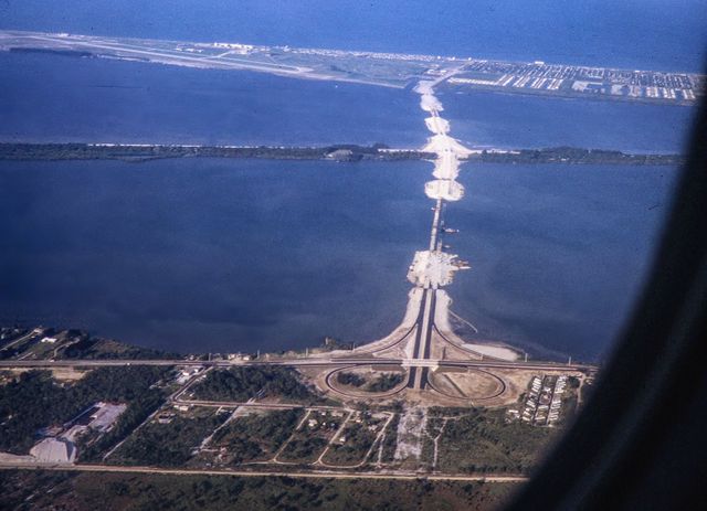
Pineda Causeway
|
|
|
| Constructed in 1973 for an estimated $7m, the Pineda Causeway spans State Road 404 across both the Indian River and Banana River lagoons from Melbourne to South Patrick Shores in Brevard County, Florida. The causeway uses eight earthen berms, two high bridge spans, and 4 relief bridges to span the lagoons.
|
| Waterway: North Indian River
|
Road: SR404
|
| City: Melbourne
|
County: Brevard
|
| Type: Concrete deck girder
|
Builder:Gregg, Gibson & Gregg
|
| DOT: 700143
|
L: 2,282.3'
|
H: 62.3'
|
Built: 1971
|
Location: 28.20614,-80.65062
|
Pineda Causeway Construction 1971
Pineda Causeway contains six bridges:
| Number
|
Water
|
Location
|
Road
|
| 700142
|
Indian River
|
West Relief
|
SR404
|
National Bridge Data
| Number
|
700142
|
| Route
|
00404
|
| Place
|
Palm Shores
|
| County
|
Brevard
|
| Features
|
Indian River West Relief
|
| Facility
|
SR-404 EB
|
| Location
|
SR-404 EB - Indian River
|
| Latitude
|
28121937
|
| Longitude
|
80392343
|
| Service On Roadway
|
Highway
|
| Service Under Roadway
|
Waterway
|
| Owner
|
FDOT
|
| Built
|
1971
|
| Rebuilt
|
|
| Lanes
|
2
|
| Lane Direction
|
1 way
|
| Direction
|
|
| Traffic
|
23000
|
| Traffic Year
|
2016
|
| Future Traffic
|
39905
|
| Future Traffic Year
|
2038
|
| Length
|
53m
|
| Width
|
13m
|
| Clearance
|
|
| Kind
|
Prestressed concrete
|
| Type
|
Stringer/Multi-beam/Girder
|
| Deck Type
|
Concrete Cast-in-Place
|
| Critical
|
|
| Inspection Date (mm-yy)
|
10-17
|
| Deck
|
Good
|
| Superstructure
|
Good
|
| Substructure
|
Satisfactory
|
| Channel
|
Bank protection is in need of minor repairs. River control devices and embankment protection have a little minor damage. Banks and/or channel have minor amounts of drift.
|
| Culvert
|
N/A
|
| Scour
|
Bridge foundations determined to be stable for assessed or calculated scour condition. Scour is determined to be within the limits of footing or piles (Example B) by assessment (i.e.,bridge foundations are on rock formations that have been determined to resist scour within the service life of the bridge), by calculations or by installation of properly designed countermeasures
|
|
| Number
|
Water
|
Structure
|
Road
|
| 700143
|
Indian River
|
Main Span
|
SR404
|
National Bridge Data
| Number
|
700143
|
| Route
|
00404
|
| Place
|
55385
|
| County
|
Brevard
|
| Features
|
Indian River
|
| Facility
|
SR-404 EB
|
| Location
|
SR-404 EB - Indian River
|
| Latitude
|
28122256
|
| Longitude
|
80390039
|
| Service On Roadway
|
Highway
|
| Service Under Roadway
|
Waterway
|
| Owner
|
FDOT
|
| Built
|
1971
|
| Rebuilt
|
|
| Lanes
|
2
|
| Lane Direction
|
1 way
|
| Direction
|
|
| Traffic
|
23000
|
| Traffic Year
|
2016
|
| Future Traffic
|
39905
|
| Future Traffic Year
|
2038
|
| Length
|
696m
|
| Width
|
11m
|
| Clearance
|
|
| Kind
|
Prestressed concrete
|
| Type
|
Stringer/Multi-beam/Girder
|
| Deck Type
|
Concrete Cast-in-Place
|
| Critical
|
|
| Inspection Date (mm-yy)
|
04-16
|
| Deck
|
Good
|
| Superstructure
|
Satisfactory
|
| Substructure
|
Fair
|
| Channel
|
Bank protection is in need of minor repairs. River control devices and embankment protection have a little minor damage. Banks and/or channel have minor amounts of drift.
|
| Culvert
|
N/A
|
| Scour
|
Bridge foundations determined to be stable for assessed or calculated scour condition. Scour is determined to be within the limits of footing or piles (Example B) by assessment (i.e.,bridge foundations are on rock formations that have been determined to resist scour within the service life of the bridge), by calculations or by installation of properly designed countermeasures
|
|
| Number
|
Water
|
Structure
|
Road
|
| 700144
|
Indian River
|
East Relief
|
SR404
|
National Bridge Data
| Number
|
700144
|
| Route
|
00404
|
| Place
|
55385
|
| County
|
Brevard
|
| Features
|
Indian River Relief East
|
| Facility
|
SR-404 EB
|
| Location
|
SR-404 EB -Indian Riv Rel
|
| Latitude
|
28122580
|
| Longitude
|
80383763
|
| Service On Roadway
|
Highway - Pedestrian
|
| Service Under Roadway
|
Waterway
|
| Owner
|
FDOT
|
| Built
|
1971
|
| Rebuilt
|
|
| Lanes
|
2
|
| Lane Direction
|
1 way
|
| Direction
|
|
| Traffic
|
23000
|
| Traffic Year
|
2016
|
| Future Traffic
|
39905
|
| Future Traffic Year
|
2038
|
| Length
|
53m
|
| Width
|
13m
|
| Clearance
|
|
| Kind
|
Prestressed concrete
|
| Type
|
Stringer/Multi-beam/Girder
|
| Deck Type
|
Concrete Cast-in-Place
|
| Critical
|
|
| Inspection Date (mm-yy)
|
11-17
|
| Deck
|
Good
|
| Superstructure
|
Good
|
| Substructure
|
Good
|
| Channel
|
Banks are protected or well vegetated. River control devices such as spur dikes and embankment protection are not required or are in a stable condition.
|
| Culvert
|
N/A
|
| Scour
|
Bridge foundations determined to be stable for assessed or calculated scour condition. Scour is determined to be within the limits of footing or piles (Example B) by assessment (i.e.,bridge foundations are on rock formations that have been determined to resist scour within the service life of the bridge), by calculations or by installation of properly designed countermeasures
|
|
| Number
|
Water
|
Structure
|
Road
|
| 700146
|
Banana River
|
West Relief
|
SR404
|
National Bridge Data
| Number
|
700146
|
| Route
|
00404
|
| Place
|
Merritt Island
|
| County
|
Brevard
|
| Features
|
Banana River Relief West
|
| Facility
|
SR-404 EB
|
| Location
|
SR-404 EB-Banana Riv Rel
|
| Latitude
|
28123224
|
| Longitude
|
80380201
|
| Service On Roadway
|
Highway
|
| Service Under Roadway
|
Waterway Relief
|
| Owner
|
FDOT
|
| Built
|
1971
|
| Rebuilt
|
|
| Lanes
|
2
|
| Lane Direction
|
1 way
|
| Direction
|
|
| Traffic
|
21000
|
| Traffic Year
|
2016
|
| Future Traffic
|
36435
|
| Future Traffic Year
|
2038
|
| Length
|
92m
|
| Width
|
13m
|
| Clearance
|
|
| Kind
|
Prestressed concrete
|
| Type
|
Stringer/Multi-beam/Girder
|
| Deck Type
|
Concrete Cast-in-Place
|
| Critical
|
|
| Inspection Date (mm-yy)
|
11-17
|
| Deck
|
Good
|
| Superstructure
|
Good
|
| Substructure
|
Good
|
| Channel
|
Bank protection is in need of minor repairs. River control devices and embankment protection have a little minor damage. Banks and/or channel have minor amounts of drift.
|
| Culvert
|
N/A
|
| Scour
|
Bridge foundations determined to be stable for assessed or calculated scour condition. Scour is determined to be within the limits of footing or piles (Example B) by assessment (i.e.,bridge foundations are on rock formations that have been determined to resist scour within the service life of the bridge), by calculations or by installation of properly designed countermeasures
|
|
| Number
|
Water
|
Structure
|
Road
|
| 700147
|
Banana River
|
Main Span
|
SR404
|
National Bridge Data
| Number
|
700147
|
| Route
|
00404
|
| Place
|
55385
|
| County
|
Brevard
|
| Features
|
Banana River
|
| Facility
|
SR-404 EB
|
| Location
|
SR-404 EB - Banana River
|
| Latitude
|
28123691
|
| Longitude
|
80374128
|
| Service On Roadway
|
Highway
|
| Service Under Roadway
|
Waterway
|
| Owner
|
FDOT
|
| Built
|
1971
|
| Rebuilt
|
|
| Lanes
|
2
|
| Lane Direction
|
1 way
|
| Direction
|
|
| Traffic
|
21000
|
| Traffic Year
|
2016
|
| Future Traffic
|
36435
|
| Future Traffic Year
|
2038
|
| Length
|
305m
|
| Width
|
11m
|
| Clearance
|
|
| Kind
|
Prestressed concrete
|
| Type
|
Stringer/Multi-beam/Girder
|
| Deck Type
|
Concrete Cast-in-Place
|
| Critical
|
|
| Inspection Date (mm-yy)
|
04-16
|
| Deck
|
Good
|
| Superstructure
|
Good
|
| Substructure
|
Satisfactory
|
| Channel
|
Bank protection is in need of minor repairs. River control devices and embankment protection have a little minor damage. Banks and/or channel have minor amounts of drift.
|
| Culvert
|
N/A
|
| Scour
|
Bridge foundations determined to be stable for assessed or calculated scour condition. Scour is determined to be within the limits of footing or piles (Example B) by assessment (i.e.,bridge foundations are on rock formations that have been determined to resist scour within the service life of the bridge), by calculations or by installation of properly designed countermeasures
|
|
| Number
|
Water
|
Structure
|
Road
|
| 700148
|
Banana River
|
East Relief
|
SR404
|
National Bridge Data
| Number
|
700148
|
| Route
|
00404
|
| Place
|
55385
|
| County
|
Brevard
|
| Features
|
Banana River Relief East
|
| Facility
|
SR-404 EB
|
| Location
|
SR-404 EB-Banana River
|
| Latitude
|
28124312
|
| Longitude
|
80371385
|
| Service On Roadway
|
Highway
|
| Service Under Roadway
|
Waterway Relief
|
| Owner
|
FDOT
|
| Built
|
1971
|
| Rebuilt
|
|
| Lanes
|
2
|
| Lane Direction
|
1 way
|
| Direction
|
|
| Traffic
|
21000
|
| Traffic Year
|
2016
|
| Future Traffic
|
36435
|
| Future Traffic Year
|
2038
|
| Length
|
92m
|
| Width
|
13m
|
| Clearance
|
|
| Kind
|
Prestressed concrete
|
| Type
|
Stringer/Multi-beam/Girder
|
| Deck Type
|
Concrete Cast-in-Place
|
| Critical
|
|
| Inspection Date (mm-yy)
|
11-17
|
| Deck
|
Satisfactory
|
| Superstructure
|
Satisfactory
|
| Substructure
|
Satisfactory
|
| Channel
|
Bank is beginning to slump. River control devices and embankment protection have widespread minor damage. There is minor stream bed movement evident. Debris is restricting the channel slightly.
|
| Culvert
|
N/A
|
| Scour
|
Countermeasures have been installed to mitigate an existing problem with scour and to reduce the risk of bridge failure during a flood event. Instructions contained in a plan of action have been implemented to reduce the risk to users from a bridge failure during or immediately after a flood event.
|
|

