Category:Bridges: Difference between revisions
mNo edit summary |
mNo edit summary |
||
| Line 44: | Line 44: | ||
The bridge data table can be sorted by county, location, and roadway. It displays a bridge's physical data (length, width, height), construction detail (year built, materials, type), and inspection report. View [[Bridge Data Table]] for detailed information on Indian River Lagoon bridges.</div> | The bridge data table can be sorted by county, location, and roadway. It displays a bridge's physical data (length, width, height), construction detail (year built, materials, type), and inspection report. View [[Bridge Data Table]] for detailed information on Indian River Lagoon bridges.</div> | ||
<div class="irlcontentmiddle irlspotlight"> | |||
<h2>IRL Bridge Data</h2> | |||
[[File:IRLN-logo-database.png|80px|right|IRL Bridge Data|link=]] | |||
* Toggle additional elements into the table | |||
* Click "+" to view Inspection Details | |||
* Click the column header to sort the table | |||
* Enter a search term | |||
<br/> | |||
{{#cargo_query: | |||
tables=bridge_data | |||
|fields=Facility_007, Features_006a, Number_008, Location_009, Place_004, County_003, Length_049, Width_052, Built_027, Rebuilt_106, Traffic_029, Kind_043a, Type_043b, Inspect_Date_090, Deck_058, Superstructure_059, Substructure_060, Channel_061, Scour_113 | |||
|where= Service_Under_042b LIKE 'Waterway' AND County_003 LIKE 'Brevard' AND Type_043b <> 'Culvert' | |||
|order by= Number_008 | |||
|limit=20 | |||
|format=dynamic table | |||
|rows per page=20 | |||
|details fields= Kind 043a, Type 043b, Inspect Date 090, Deck 058, Superstructure 059, Substructure 060, Channel 061, Scour 113 | |||
|hidden fields= Number_008, Location_009, Place_004, County_003, Length_049, Width_052, Built_027, Rebuilt_106, Traffic_029 | |||
|more results text= * Get More Bridges | |||
}} | |||
</div> | |||
<div class="irlcontentmiddle"> | <div class="irlcontentmiddle"> | ||
Revision as of 13:01, November 15, 2020
Bridge and Causeway Definition
Florida has thousands of bridges and causeways. Many people use the words interchangeably. So what is the difference between a bridge, a causeway and a causeway bridge?[1]
Bridge - a structure carrying a road, path, railroad, or canal across a river, ravine, road, railroad, or other obstacle.
Causeway - a raised road or track across low or wet ground.
Causeway Bridge - An earthen berm causeway with a bridge in the middle.
Bridge Info Table
An information box is a brief summary including image, location, description, physical detail, and a map. Info boxes may be embedded on other pages on this site.
 | ||||
| Waterway: Mosquito Lagoon | Road: SR3 | |||
| City: Allenhurst | County: Brevard | |||
| Type: Bascule Double Leaf | Builder:McCormick and Sons | |||
| DOT: 703004 | H: 27' | Built: 1964-01-01 | ||
Location: (28.73634,-80.75459)
Tap for active map.
| ||||
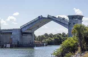
| 1964 U.S. Army Corps of Engineers' Bascule double leaf drawbridge crossing Florida SR3 (N Courtney Parkway) over the Haulover Canal in the Merritt Island Wildlife Refuge. Article | ||||
The Bridge Info Table below lists the info boxes available on this site. An (info) link points to a page that displays the bridge's information box plus any additional collected content. An Article link points to a bridge's full page article in the Indian River Lagoon encyclopedia.
IRL Bridge Info
- Click '+' to show the description.
- 'Toggle' in additional columns
- Click a column header to resort
- Search by name, location, roadway, waterbody
| Name | Water | Road | City | County | Article | |
|---|---|---|---|---|---|---|
| Name | Water | Road | City | County | Article | |
| Alma Lee Loy Bridge (info) | Central Indian River | CR656 | Vero Beach | Indian River | ||
| Canaveral Locks Bridge (info) | Banana River | SR401 | Cape Canaveral | Brevard | Canaveral Locks Bridge | |
| Eau Gallie Causeway (info) | North Indian River | SR518 | Melbourne | Brevard | ||
| Ernest Lyons Bridge (info) | South Indian River | A1A | Sewell's Point | Martin | ||
| Haulover Canal Bridge (info) | Mosquito Lagoon | SR3 | Allenhurst | Brevard | Haulover Canal | |
| Mathers Bridge (info) | Banana River | SR3 | Indian Harbour Beach | Brevard | Mathers Bridge Historic Engineering Record | |
| Max Brewer Bridge (info) | North Indian River | SR406 | Titusville | Brevard | Max Brewer Bridge | |
| Merrill Barber Bridge (info) | Central Indian River | SR60 | Vero Beach | Indian River | Merrill Barber Bridge | |
| NASA Causeway Indian River (info) | North Indian River | SR405 | Titusville | Brevard | ||
| Pineda Causeway (info) | North Indian River | SR404 | Melbourne | Brevard | ||
| Roosevelt Bridge (info) | Saint Lucie River | US1 | Stuart | Martin | ||
| Sebastian Inlet Bridge (info) | Central Indian River | A1A | Indian River Oaks | Brevard | Sebastian Inlet | |
| Wabasso Bridge (info) | Central Indian River | SR510 | Wabasso | Indian River | Wabasso Bridge |
Bridge Data
Bridge Data Table displays the National Bridge Inventory[2] data for bridges in the six Indian River Lagoon National Estuary counties (Volusia, Brevard, Indian River, St. Lucie, Martin and Palm Beach). The bridge data table includes information for over 1400 culvert, overpass and waterway bridges in the Indian River Lagoon watershed.
The bridge data table can be sorted by county, location, and roadway. It displays a bridge's physical data (length, width, height), construction detail (year built, materials, type), and inspection report. View Bridge Data Table for detailed information on Indian River Lagoon bridges.IRL Bridge Data
- Toggle additional elements into the table
- Click "+" to view Inspection Details
- Click the column header to sort the table
- Enter a search term
| Facility 007 | Features 006a | Number 008 | Location 009 | Place 004 | County 003 | Length 049 | Width 052 | Built 027 | Rebuilt 106 | Traffic 029 | |
|---|---|---|---|---|---|---|---|---|---|---|---|
| Facility 007 | Features 006a | Number 008 | Location 009 | Place 004 | County 003 | Length 049 | Width 052 | Built 027 | Rebuilt 106 | Traffic 029 | |
| 'US-1 ' | 'Elbow Creek ' | 700007 | 'US-1 over Elbow Creek ' | Melbourne | Brevard | 98 | 30 | 1961 | 1990 | 46500 | |
| 'US-1 ' | 'Eau Gallie River ' | 700008 | 'US-1- Eau Gallie River ' | Melbourne | Brevard | 82 | 30 | 1961 | 1990 | 52000 | |
| 'SR-50 WB ' | 'St. Johns River ' | 700013 | 'SR-50 WB -St Johns River ' | Brevard | 70 | 13 | 1971 | 5400 | |||
| 'US-192 EB ' | 'Sawgrass Creek ' | 700018 | 'US-192EB - Sawgrass Creek' | Brevard | 21 | 14 | 1967 | 2004 | 4400 | ||
| 'SR-528 ' | 'Sykes Creek ' | 700025 | 'SR-528 WB - Sykes Creek ' | Cape Canaveral | Brevard | 37 | 10 | 1963 | 2002 | 12250 | |
| 'SR-528 ' | 'Banana River ' | 700028 | '0.7MI W OF SR-401 ' | Cape Canaveral | Brevard | 340 | 10 | 1963 | 19500 | ||
| 'I-95 SB ' | 'Tillman Canal ' | 700034 | 'I-95 SB- Tillman Canal ' | Malabar | Brevard | 93 | 18 | 1964 | 2010 | 32250 | |
| 'SR-3 ' | 'Barge Canal ' | 700072 | 'SR-3 SB over Barge Canal ' | Merritt Island | Brevard | 91 | 11 | 1961 | 1998 | 14500 | |
| 'SR-404 WB ' | 'Indian River West Relief' | 700076 | 'SR-404 WB - Indian River ' | Palm Shores | Brevard | 53 | 13 | 1971 | 23000 | ||
| 'SR-404 WB ' | 'Indian River ' | 700077 | 'SR-404 WB - Indian River ' | 55385 | Brevard | 696 | 11 | 1971 | 23000 | ||
| 'SR-404 WB ' | 'Indian River Relief East' | 700078 | 'SR-404 WB-Indian River ' | 55380 | Brevard | 53 | 13 | 1971 | 23000 | ||
| 'SR-404 WB ' | 'Banana River ' | 700081 | 'SR-404 WB - Banana River ' | 55385 | Brevard | 305 | 11 | 1971 | 21000 | ||
| 'SR-528 ' | 'St Johns River ' | 700084 | 'SR-528 WB-St Johns River ' | Brevard | 166 | 13 | 1973 | 21300 | |||
| 'I-95 ' | 'Sottile Canal ' | 700096 | 'I-95 SB - Sottile Canal ' | Brevard | 40 | 18 | 1969 | 2014 | 21382 | ||
| 'SR-50 EB ' | 'St. Johns River ' | 700107 | 'SR-50 EB -St Johns River ' | Brevard | 70 | 13 | 1971 | 5400 | |||
| 'SR-528 WB ' | 'Indian River ' | 700110 | 'SR-528 WB - Indian River ' | Merritt Island | Brevard | 702 | 11 | 1970 | 25474 | ||
| 'SR-528 ' | 'Sykes Creek ' | 700112 | 'SR-528 EB - Sykes Creek ' | Cape Canaveral | Brevard | 37 | 11 | 1970 | 12250 | ||
| 'SR-528 ' | 'Banana River ' | 700115 | '1.0MI E OF BANANA RIV DR ' | Cape Canaveral | Brevard | 341 | 11 | 1971 | 19500 | ||
| 'I-95 NB ' | 'Tillman Canal ' | 700119 | 'I-95 NB - Tillman Canal ' | Malabar | Brevard | 93 | 18 | 1964 | 2010 | 32250 | |
| 'SR-404 EB ' | 'Indian River West Relief' | 700142 | 'SR-404 EB - Indian River ' | Palm Shores | Brevard | 53 | 13 | 1971 | 23000 |
Bridge List
Bridge_List is a manually updated list of waterway bridges in Mosquito, Banana River and Indian River lagoons.
- Click expand to open the list.
- Blue text links point to encyclopedia articles
- (info) links point to info box pages.
Halifax River Bridges
Volusia County
- Granada Bridge SR40
- Seabreeze Bridge SR430
- Main Street Bridge
- Broadway Bridge
- Veterans Memorial Bridge CR4050
- Port Orange Causeway USA1A
Mosquito Lagoon Bridges
Volusia County
- South Causeway SR44
Mosquito Lagoon Bridges
Brevard County
- Haulover Canal Bridge CR3 (info)
Banana River Bridges
Brevard County
- Kennedy Parkway Bridge CR3
- Saturn Causeway
- NASA Parkway Causeway SR405
- Beachline Causeway SR528
- Canaveral Locks Bridge SR401 (info)
- Hubert Humphrey Bridge SR520
- Pineda Causeway SR404 (info)
- Mathers Bridge CR3 (info)
Indian River Bridges
Brevard County
- NASA Railroad Bridge
- A. Max Brewer Memorial Parkway SR406 (info)
- NASA Parkway Causeway SR405 (info)
- Beachline Causeway SR528
- Hubert Humphrey Bridge SR520
- Pineda Causeway SR404 (info)
- Eau Gallie Causeway SR518 (info)
- Melbourne Causeway US192
- Sebastian Inlet Bridge A1A (info)
Indian River County
- Wabasso Causeway SR510 (info)
- Merrill P. Barber Bridge (info)
- Alma Lee Loy Bridge SR656 (info)
St. Lucie County
- North Causeway USA1A
- Seaway Drive Causeway USA1A
Martin County
- Frank Wacha Bridge CR732
- Ocean Blvd Causeway
- Ernest Lyons Bridge A1A (info)
- Evans Crary Bridge A1A - St.Lucie River
- Roosevelt Bridge US1 - St. Lucie River (info)
- SE Bridge Rd. Causeway CR707
Palm Beach County
- South Beach Road Causeway CR707
Web Links
Documents
References
- ↑ TCPalm You Tube Channel
- ↑ National Bridge Inventory, retrieved 11/15/2020.
Subcategories
This category has the following 5 subcategories, out of 5 total.
B
- Banana River Bridges (4 P)
H
- Halifax River Bridges (empty)
I
M
- Mosquito Lagoon Bridges (1 P)
S
- Saint Lucie River Bridges (1 P)
Pages in category "Bridges"
The following 2 pages are in this category, out of 2 total.