Category:Indian River Bridges: Difference between revisions
mNo edit summary |
mNo edit summary |
||
| (12 intermediate revisions by the same user not shown) | |||
| Line 1: | Line 1: | ||
<div class="irlbody"> | <div class="irlbody"> | ||
{{IRL header estuary|cat=Bridges|toc= | {{IRL header estuary|cat=Bridges|toc=yes}} | ||
<div class="irlcontenttop"> | <p class="irlsubtitle">Bridges and Causeways across the Indian River.</p> | ||
==Indian River | <div class="irlcontenttop irlabout"> | ||
[[File:Wabasso_Bridge_Old.jpg|360px|frameless|right|alt=Old Wabasso Bridge|Old Wabasso Bridge - Indian River County]] | |||
Until 1920, there were only two bridges spanning across the Indian River, one in Brevard County's Cocoa and the second in Martin County's Hobe Sound. | |||
On Labor Day in 1920, a new wooden Vero Bridge opened and access to the ocean was available to all who lived on the Vero mainland. | |||
For boat traffic, a bridge tender, who lived in a house near the middle of the crossing, would open the metal swing span by hand. Tolls were charged to cross the bridge, ranging from 5 cents for pedestrians, 10 cents for horses and 35 cents for delivery trucks.<ref name=tcpalm /> | |||
In 1925, construction began on the first wooden bridge across the Indian River Lagoon in Eau Gallie. On February 22, 1926, the bridge opened to vehicle traffic headed to a sand trail at Canova Beach. There was no railing on the bridge for a year after its construction. There are no records that anyone fell off the bridge during this time.<ref name=wiki /> | |||
[[File:Max_Brewer_Bridge_001.jpg|360px|frameless|right|alt=Max Brewer Bridge, Titusville, Florida|Max Brewer Bridge, Titusville, Florida]] | |||
Post War 1940's the U.S. government funded construction of new bridges across the Indian River. | |||
As Florida's population grew, more traffic headed to the barrier islands, and modern bridges created from steel and concrete were constructed. These early concrete and steel bridges used earthen berms to partially span the river, with a lift or swing drawbridge in the middle to allow tall boats to pass. | |||
A boat unable to pass under the bridge would signal the tender, who was in a shack hanging off the bridge's side, to open the drawbridge so they could pass through. In less populated areas, the drawbridges were unattended at night, and boats would anchor to await the bridge tender's return the next morning. | |||
</div> | |||
<div class="irlcontentmiddle"> | |||
<div class="wikitable"> | <div class="wikitable"> | ||
<div class=" | <div class="irlheaderright"><div class="irlheaderformbutton">[[Form:Bridge|Add Bridge]]</div></div> | ||
<h2 class="irltabletitle">Bridge Info</h2> | |||
{{#cargo_query: | {{#cargo_query: | ||
tables=bridge | tables=bridge | ||
| Line 19: | Line 36: | ||
<div class="irlcontentmiddle"> | <div class="irlcontentmiddle"> | ||
==Bridge List== | ==Bridge List== | ||
[[Bridge List]] is a | [[Bridge List]] is a text list of all bridges and causeways across the Indian River. | ||
<div class="mw-collapsible" style="width:340px; overflow:auto;"> | |||
<div class="mw-collapsible | |||
<div class="irlcollapsetitle">Indian River Bridge List</div> | <div class="irlcollapsetitle">Indian River Bridge List</div> | ||
<div> | |||
* Click expand/collapse to open/close the list. | |||
* Blue text links point to articles | |||
* (info) links point to info pages. | |||
* Bridges are listed from North to South. | |||
</div> | |||
<div class="mw-collapsible-content"> | <div class="mw-collapsible-content"> | ||
<div>{{#section:Bridge List|indianriverbridgelist}}</div> | |||
<div>{{#section:Bridge List| | |||
</div></div> | </div></div> | ||
</div> | </div> | ||
<div class="irlcontentbottom"> | <div class="irlcontentbottom"> | ||
==Web Links== | ==Web Links== | ||
* [https://infobridge.fhwa.dot.gov/ FHWA - InfoBridge Data Explorer] | * [https://infobridge.fhwa.dot.gov/ FHWA - InfoBridge Data Explorer] | ||
| Line 37: | Line 56: | ||
==Documents== | ==Documents== | ||
* [https://fdotwww.blob.core.windows.net/sitefinity/docs/default-source/maintenance/str/bi/annual_rpt_20.pdf Florida Bridge Inventory 2020 (PDF 68pp 10.5MB)] | * [https://fdotwww.blob.core.windows.net/sitefinity/docs/default-source/maintenance/str/bi/annual_rpt_20.pdf Florida Bridge Inventory 2020 (PDF 68pp 10.5MB)] | ||
</ | ==References== | ||
<references> | |||
<ref name=tcpalm>[https://www.tcpalm.com/story/news/local/indian-river-county/2019/04/18/3-bridges-spanning-indian-river-mainland-orchid-island-have-quite-stories-tell/3495957002/ Vero Beach Centennial: Barber, Alma Lee Loy, Wabasso bridges built as county population grew]</ref> | |||
<ref name=wiki>[https://en.wikipedia.org/wiki/Eau_Gallie_Causeway Eau Gallie Causeway]</ref> | |||
</references> | |||
{{IRL footer estuary|cat=Indian River Bridges}} | |||
</div> | </div> | ||
[[Category:Bridges]] | [[Category:Bridges]] | ||
Latest revision as of 04:24, November 23, 2021
Bridges and Causeways across the Indian River.
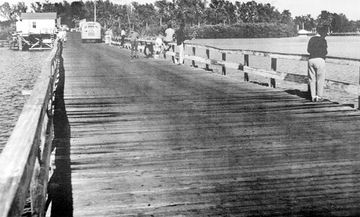
Until 1920, there were only two bridges spanning across the Indian River, one in Brevard County's Cocoa and the second in Martin County's Hobe Sound.
On Labor Day in 1920, a new wooden Vero Bridge opened and access to the ocean was available to all who lived on the Vero mainland.
For boat traffic, a bridge tender, who lived in a house near the middle of the crossing, would open the metal swing span by hand. Tolls were charged to cross the bridge, ranging from 5 cents for pedestrians, 10 cents for horses and 35 cents for delivery trucks.[1]
In 1925, construction began on the first wooden bridge across the Indian River Lagoon in Eau Gallie. On February 22, 1926, the bridge opened to vehicle traffic headed to a sand trail at Canova Beach. There was no railing on the bridge for a year after its construction. There are no records that anyone fell off the bridge during this time.[2]
Post War 1940's the U.S. government funded construction of new bridges across the Indian River.
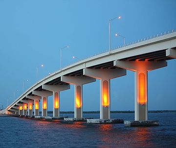
As Florida's population grew, more traffic headed to the barrier islands, and modern bridges created from steel and concrete were constructed. These early concrete and steel bridges used earthen berms to partially span the river, with a lift or swing drawbridge in the middle to allow tall boats to pass.
A boat unable to pass under the bridge would signal the tender, who was in a shack hanging off the bridge's side, to open the drawbridge so they could pass through. In less populated areas, the drawbridges were unattended at night, and boats would anchor to await the bridge tender's return the next morning.
Bridge Info
Toggle columns: Water - County - Article| Name | Water | Road | County | Article | |
|---|---|---|---|---|---|
| Name | Water | Road | County | Article | |
| Alma Lee Loy Bridge (info) | Central Indian River | CR656 | Indian River | ||
| Eau Gallie Causeway (info) | North Indian River | SR518 | Brevard | ||
| Ernest Lyons Bridge (info) | South Indian River | A1A | Martin | ||
| Max Brewer Bridge (info) | North Indian River | SR406 | Brevard | Max Brewer Bridge | |
| Merrill Barber Bridge (info) | Central Indian River | SR60 | Indian River | Merrill Barber Bridge | |
| NASA Causeway Indian River (info) | North Indian River | SR405 | Brevard | ||
| Pineda Causeway (info) | North Indian River | SR404 | Brevard | ||
| Sebastian Inlet Bridge (info) | Central Indian River | A1A | Brevard | Sebastian Inlet | |
| Wabasso Bridge (info) | Central Indian River | SR510 | Indian River | Wabasso Bridge |
Bridge List
Bridge List is a text list of all bridges and causeways across the Indian River.
- Click expand/collapse to open/close the list.
- Blue text links point to articles
- (info) links point to info pages.
- Bridges are listed from North to South.
Brevard County
- NASA Railroad Bridge
- A. Max Brewer Memorial Parkway SR406 (info)
- NASA Parkway Causeway SR405 (info)
- Beachline Causeway SR528
- Hubert Humphrey Bridge SR520
- Pineda Causeway SR404 (info)
- Eau Gallie Causeway SR518 (info)
- Melbourne Causeway US192
- Sebastian Inlet Bridge A1A (info)
Indian River County
- Wabasso Causeway SR510 (info)
- Merrill P. Barber Bridge (info)
- Alma Lee Loy Bridge SR656 (info)
St. Lucie County
- North Causeway USA1A
- Seaway Drive Causeway USA1A
Martin County
- Frank Wacha Bridge CR732
- Ocean Blvd Causeway
- Ernest Lyons Bridge A1A (info)
- Evans Crary Bridge A1A - St.Lucie River
- Roosevelt Bridge US1 - St. Lucie River (info)
- SE Bridge Rd. Causeway CR707
Palm Beach County
- South Beach Road Causeway CR707
Subcategories
This category has the following 3 subcategories, out of 3 total.
C
- Central Indian River Bridges (6 P)
N
- North Indian River Bridges (5 P)
S
- South Indian River Bridges (1 P)


