Category:North Indian River Bridges
Bridge Info Box
An information box is a brief summary including image, location, description, physical detail, and a map. Info boxes may be embedded on other pages on this site.
 | ||||
| Waterway: North Indian River | Road: SR404 | |||
| City: Melbourne | County: Brevard | |||
| Type: Concrete deck girder | Builder:Gregg, Gibson & Gregg | |||
| DOT: 700143 | L: 2282' | H: 62' | Built: 1971-01-01 | |
Location: (28.20614,-80.65062)
Tap for active map.
| ||||
| Constructed in 1973 for an estimated $7m, the Pineda Causeway spans State Road 404 across both the Indian River and Banana River lagoons from Melbourne to South Patrick Shores in Brevard County, Florida. The causeway uses eight earthen berms, two high bridge spans, and 4 relief bridges to span the lagoons. | ||||
| Name | FDOT | Road | Water | City | County | Article | |
|---|---|---|---|---|---|---|---|
| Name | FDOT | Road | Water | City | County | Article | |
| Eau Gallie Causeway (info) | 700184 | SR518 | North Indian River | Melbourne | Brevard | ||
| Max Brewer Bridge (info) | 700227 | SR406 | North Indian River | Titusville | Brevard | Max Brewer Bridge | |
| NASA Causeway Indian River (info) | 703001 | SR405 | North Indian River | Titusville | Brevard | ||
| Pineda Causeway (info) | 700143 | SR404 | North Indian River | Melbourne | Brevard |
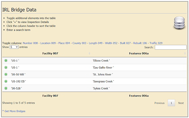
Bridge Data Table
Bridge Data Table displays the National Bridge Inventory[1] data for bridges in the six Indian River Lagoon National Estuary counties (Volusia, Brevard, Indian River, St. Lucie, Martin and Palm Beach). The data table includes information on over 1400 culvert, overpass and waterway bridges in the Indian River Lagoon watershed.
The bridge data table can be sorted by county, location, and roadway. It displays a bridge's physical data, construction detail, and inspection report. View Bridge Data Table for detailed information on Indian River Lagoon bridges.
Bridge List
Bridge_List is a manually updated list of waterway bridges in Mosquito, Banana River and Indian River lagoons.
- Click expand to open the list.
- Blue text links point to encyclopedia articles
- (info) links point to info box pages.
Brevard County
- NASA Railroad Bridge
- A. Max Brewer Memorial Parkway SR406 (info)
- NASA Parkway Causeway SR405 (info)
- Beachline Causeway SR528
- Hubert Humphrey Bridge SR520
- Pineda Causeway SR404 (info)
- Eau Gallie Causeway SR518 (info)
- Melbourne Causeway US192
- Sebastian Inlet Bridge A1A (info)
Indian River County
- Wabasso Causeway SR510 (info)
- Merrill P. Barber Bridge (info)
- Alma Lee Loy Bridge SR656 (info)
St. Lucie County
- North Causeway USA1A
- Seaway Drive Causeway USA1A
Martin County
- Frank Wacha Bridge CR732
- Ocean Blvd Causeway
- Ernest Lyons Bridge A1A (info)
- Evans Crary Bridge A1A - St.Lucie River
- Roosevelt Bridge US1 - St. Lucie River (info)
- SE Bridge Rd. Causeway CR707
Palm Beach County
- South Beach Road Causeway CR707
Pages in category "North Indian River Bridges"
The following 5 pages are in this category, out of 5 total.