Category:Brevard County Region: Difference between revisions
(Created page with "<div class="irlbody"><!-- Body Content Div --> <div class="irlheader"><!-- Header Div --> {{IRL header locale}} <p class="irlsubtitle">Brevard County is home to Mosquito Lagoo...") |
|||
| (46 intermediate revisions by the same user not shown) | |||
| Line 1: | Line 1: | ||
<div class="irlbody" | <div class="irlbody"> | ||
{{IRL header|cat=Region}} | |||
{{IRL header | <div class="irlcontenttop"> | ||
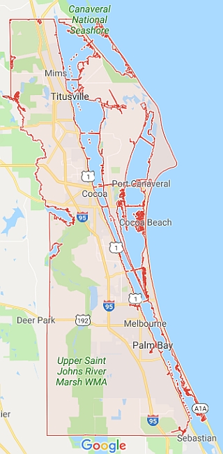
< | [[File:Map_brevard_001.jpg|320px|thumb|right|alt=Map of Brevard County, Florida|'''[[:Category:Brevard County|Brevard County, Florida]]'''|link=:Category:Brevard County]] | ||
</div>< | |||
<div class=" | '''Brevard County Region''' displays local Indian River Lagoon news articles, events and regional information for [[Brevard County|Brevard County, Florida]]. | ||
<div class=" | |||
<div class=" | Brevard County is located on Central Florida's East Coast. It is bounded by the St. Johns River plain on the west and the Atlantic Ocean on the east. Brevard has a total area of 1,557 square miles, of which 1,016 square miles is land and 541 square miles (34.8%) is water. Strongly influenced by NASA's 140,000 acre Kennedy Space Center, Brevard County is also known as the ''"Space Coast"''. | ||
== | |||
Brevard contains 71% of the [[Indian River Lagoon Estuary|Indian River Lagoon National Estuary]], almost 50% of it's length, and is home to the entire [[Banana River]] lagoon, most of [[Mosquito Lagoon]], and the North and Central zones of the [[Indian River]]. | |||
</div>< | |||
<div class=" | |||
== | '''See Also:''' | ||
* [[Brevard County|IRL Encyclopedia Article - Brevard County]] | |||
{{ | * [[:Category:Brevard County|IRL Encyclopedia Category - Brevard County]] | ||
==Brevard County IRL Watershed== | |||
<div class="mw-collapsible mw-collapsed" style="width:330px; overflow:auto;"> | |||
<div class="irlcollapsetitle">Brevard County IRL Tributaries</div> | |||
<div class="mw-collapsible-content"> | |||
<div class="irlcollapsetext">Tributaries are listed North to South.</div> | |||
<div>{{#section:Water Body List|irlestuarywaterbrevard}}</div> | |||
</div></div> | |||
<div class="mw-collapsible mw-collapsed" style="width:330px; overflow:auto;"> | |||
<div class="irlcollapsetitle">Brevard County IRL Bridges</div> | |||
<div class="mw-collapsible-content"> | |||
<div class="irlcollapsetext">Bridges are listed North to South.</div> | |||
<div>{{#section:Bridge List|brevardbridgelist}}</div> | |||
</div></div> | |||
</div> | |||
<div class="irlcontentmiddle"> | |||
==Brevard County IRL News== | |||
{{#cargo_query: | |||
tables=News_Link | |||
|fields= _pageName, Title, SubTitle, Location, Water_Body, Region, Posted, Water_Body, Region, Description, Image | |||
|where=Region LIKE 'Brevard County' | |||
|order by=Posted DESC | |||
|limit=3 | |||
|format=template | |||
|named args=yes | |||
|template=News_Link_Row | |||
|more results text= | |||
}} | |||
'''More: [[:Category:Brevard County News|Brevard County Indian River Lagoon News]]''' | |||
</div> | |||
<div class="irlcontentmiddle"> | |||
==Brevard County IRL Events== | |||
{{#cargo_query: | |||
tables=Event | |||
|fields=_pageName, Name, Event_Date, Location, Region, Description, Image | |||
|where= Region LIKE 'Brevard County' and Event_Date >= NOW() | |||
|order by= Event_Date ASC | |||
|limit=3 | |||
|format=template | |||
|named args=yes | |||
|template=Event_Row | |||
|more results text= | |||
}} | |||
'''More: [[:Category:Brevard County Events|Brevard County Indian River Lagoon Events]]''' | |||
</div> | |||
<div class="irlcontentmiddle"> | |||
==Brevard County IRL Web Links== | |||
{{#cargo_query: | |||
tables=weblink | |||
|fields= _pageName, Name, Type, Region, Site_Logo, Screenshot, Poster, Posted, Description | |||
|where=Region LIKE 'Brevard County' | |||
|order by=Posted DESC | |||
|limit=3 | |||
|format=template | |||
|named args=yes | |||
|template=Web_Link_Row | |||
|more results text= | |||
}} | |||
'''More: [[:Category:Brevard County Links|Brevard County Indian River Lagoon Web Links]]''' | |||
</div> | |||
<div class="irlcontentmiddle"> | |||
==Brevard County Map== | |||
Tap the image to activate the map. | |||
<div style="width:auto;">{{Map Embed|coord=28.2762,-80.6066|zoom=9|}}</div> | |||
</div> | |||
</div> | </div> | ||
[[Category:Brevard County]] | [[Category:Brevard County]] | ||
[[Category: | [[Category:Region]] | ||
Latest revision as of 17:43, December 28, 2021
Brevard County Region displays local Indian River Lagoon news articles, events and regional information for Brevard County, Florida.
Brevard County is located on Central Florida's East Coast. It is bounded by the St. Johns River plain on the west and the Atlantic Ocean on the east. Brevard has a total area of 1,557 square miles, of which 1,016 square miles is land and 541 square miles (34.8%) is water. Strongly influenced by NASA's 140,000 acre Kennedy Space Center, Brevard County is also known as the "Space Coast".
Brevard contains 71% of the Indian River Lagoon National Estuary, almost 50% of it's length, and is home to the entire Banana River lagoon, most of Mosquito Lagoon, and the North and Central zones of the Indian River.
See Also:
Brevard County IRL Watershed
- Haulover Canal
- Max Hoeck Back Creek
Banana River
Brevard
- Banana Creek
- Canaveral Lock
- Canaveral Barge Canal
- Sykes Creek
- Grand Canal
- Indian River
Indian River
Brevard County
- Turnbull Creek
- Haulover Canal
- Gator Creek
- Catfish Creek
- Banana Creek
- Canaveral Barge Canal
- Horse Creek
- Banana River
- Eau Gallie River
- Crane Creek
- Turkey Creek
- Goat Creek
- Kid Creek
- Trout Creek
- Mullet Creek
Mosquito Lagoon Bridges
Brevard County
- Haulover Canal Bridge CR3 (info)
Banana River Bridges
Brevard County
- Kennedy Parkway Bridge CR3
- Saturn Causeway
- NASA Parkway Causeway SR405
- Beachline Causeway SR528
- Canaveral Locks Bridge SR401 (info)
- Hubert Humphrey Bridge SR520
- Pineda Causeway SR404 (info)
- Mathers Bridge CR3 (info)
Indian River Bridges
Brevard County
Brevard County IRL News
Brevard County IRL Web Links
Brevard County Map
Tap the image to activate the map.
Subcategories
This category has the following 3 subcategories, out of 3 total.
B
- Brevard County Events (60 P)
- Brevard County Links (32 P)
- Brevard County News (45 P)


