Mosquito Lagoon Water Body: Difference between revisions
mNo edit summary |
mNo edit summary |
||
| (16 intermediate revisions by the same user not shown) | |||
| Line 1: | Line 1: | ||
<div class="irlbody"> | <div class="irlbody irlbow"> | ||
{{IRL header | {{IRL header estuary|cat=Water Body}} | ||
<div class="irlcontenttop"> | <div class="irlcontenttop"> | ||
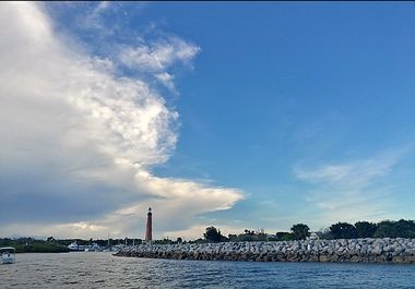
[[Image:Ponce inlet 001.jpg|380px|thumb|right|Ponce Inlet Light House]] | [[Image:Ponce inlet 001.jpg|380px|thumb|right|Ponce Inlet Light House]] | ||
Mosquito Lagoon is bounded on the north by Volusia County's [[Ponce de Leon Inlet]], [[Merritt Island National Wildlife Refuge]] to the west, [[Canaveral National Seashore]] on the east, and Kennedy Space Center to the south. | |||
The lagoon is the least developed area remaining on Central Florida's East Coast. Two thirds of Mosquito Lagoon is protected by the U.S. Fish and Wildlife Service (FWC) and NASA. The northern end of Mosquito Lagoon is protected under Florida's Department of Environmental Protection (FDEP) Aquatic Preserve program.<ref name="fdepmlap" /> | |||
Salinity levels in the Mosquito Lagoon are comparable to ocean levels (32-34 ppt) allowing several fish species to spawn in the brackish water that would normally only spawn in the ocean. Mosquito Lagoon has a resident population of [[Bottlenose dolphin|Atlantic bottlenose dolphins]], [[West Indian Manatee|manatees]] and [[American alligator|alligators]]. Mosquito Lagoon supports the northernmost extent of the [[Mangrove|red and black mangrove]] habitat.<ref name="fdepmlap" /> | |||
</div> | |||
<div class="irlcontentmiddle"> | |||
==Canaveral National Seashore== | ==Canaveral National Seashore== | ||
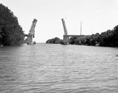
The [[Canaveral National Seashore]] is home to more than 1,000 plant species and 310 bird species. CANA occupies 57,662 acres | [[Image:haulover canal 001.jpg|380px|thumb|right|Haulover Canal]] | ||
The [[Canaveral National Seashore]] is home to more than 1,000 plant species and 310 bird species. CANA occupies 57,662 acres (including Mosquito Lagoon). The park's 24-mile-long beach is the longest undeveloped beach on the east coast of the state. | |||
The southern part is known as Playalinda Beach, the middle section as Klondike Beach, and the northern section as Apollo Beach.<ref name="cana" /> | |||
==Merritt Island National Wildlife Refuge== | ==Merritt Island National Wildlife Refuge== | ||
The [[Merritt Island National Wildlife Refuge]] traces its beginnings to the development of the nation’s Space Program. In 1962, NASA acquired 140,000 acres of land, water, and marshes adjacent to Cape Canaveral to establish the John F. Kennedy Space Center. NASA built a launch complex and other space-related facilities, but development of most of the area was not necessary. | |||
The [[Merritt Island National Wildlife Refuge]] traces its beginnings to the development of the nation’s Space Program. In 1962, NASA acquired 140,000 acres of land, water, and marshes adjacent to Cape Canaveral to establish the John F. Kennedy Space Center. NASA built a launch complex and other space-related facilities, but development of most of the area was not necessary. | |||
In 1963 the U.S. Fish and Wildlife Service signed an agreement to establish the refuge and in 1975 a second agreement established Canaveral National Seashore. Today, the Department of Interior manages most of the unused portions of the Kennedy Space Center as a National Wildlife Refuge and National Seashore.<ref name="minwr" /> | |||
==Mosquito Lagoon Aquatic Preserve== | ==Mosquito Lagoon Aquatic Preserve== | ||
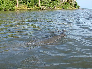
<span class="irlimageright">[[File:Mosquitolagoon.jpg| | <span class="irlimageright">[[File:Mosquitolagoon.jpg|380px|thumb|right|Manatees in Mosquito Lagoon]]</span> | ||
The Florida Department of | The Florida Department of Environmental Protection's [[Mosquito Lagoon Aquatic Preserve|Mosquito Lagoon Aquatic Preserve (MLAP)]] includes 4,740 acres in the northern end of the lagoon. | ||
The MLAP originally extended to the southern end of the lagoon, but close to two-thirds of the central and southern lagoon were transferred to the Federal government and are now part of the [[Canaveral National Seashore]]. | |||
MLAP is unique among the inland waters of the Atlantic Coast of Florida and a feeling of relative isolation is attainable just a short distance from nearby boat ramps. Once outside the Atlantic Intracoastal Waterway, local knowledge of water depths and channels of the Lagoon system is essential. Elevated landmarks are difficult to see at times, and it is easy to become disorientated among the winding turns and dead end waterways.<ref name="fdepmlap" /> | MLAP is unique among the inland waters of the Atlantic Coast of Florida and a feeling of relative isolation is attainable just a short distance from nearby boat ramps. Once outside the Atlantic Intracoastal Waterway, local knowledge of water depths and channels of the Lagoon system is essential. Elevated landmarks are difficult to see at times, and it is easy to become disorientated among the winding turns and dead end waterways.<ref name="fdepmlap" /> | ||
==Mosquito Lagoon Water Body== | |||
<div class="mw-collapsible" style="width:330px; overflow:auto;"> | |||
<div class="irlcollapsetitle">Mosquito Lagoon Tributaries</div> | |||
<div class="mw-collapsible-content"> | |||
<div class="irlcollapsetext">Tributaries are listed from North to South.</div> | |||
<div>{{#section:Water Body List|mosquitolagoonwater}}</div> | |||
</div></div> | |||
</div> | |||
<div class="irlcontentmiddle"> | |||
==Location== | |||
Mosquito Lagoon extends from the Ponce de Leon Inlet to Cape Canaveral. It connects to the [[Indian River]] via the [[Haulover Canal]] at Allenhurst. | |||
<br/><br/> | |||
'''Coordinates:''' 28°47'51.1"N 80°46'45.2"W | |||
<br/>'''GIS:''' (28.797532, -80.779221) | |||
<div class="irlmap" style="width:100%;float:left"> | |||
{{#cargo_display_map:point=28.797532, -80.779221|service=googlemaps|width=inherit|zoom=10|}} | |||
</div> | </div> | ||
<div class="irlcontentmiddle"> | <div class="irlcontentmiddle"> | ||
==Video== | ==Video== | ||
{{#ev:youtube|u8zt0he-WAE|left}} | {{#ev:youtube|u8zt0he-WAE|left}} | ||
</div> | </div> | ||
<div class="irlcontentbottom"> | <div class="irlcontentbottom"> | ||
{{IRL_notice_water_body}} | |||
==See Also== | |||
* [[Mosquito Lagoon]] | |||
* [[Mosquito Lagoon Aquatic Preserve]] | |||
* [[Ponce de Leon Inlet]] | |||
* [[Haulover Canal]] | |||
* [[Info:Haulover Canal Bridge]] | |||
==Web Links== | ==Web Links== | ||
* [https://floridadep.gov/rcp/aquatic-preserve/locations/mosquito-lagoon-aquatic-preserve FDEP - Mosquito Lagoon Aquatic Preserve] | * [https://floridadep.gov/rcp/aquatic-preserve/locations/mosquito-lagoon-aquatic-preserve FDEP - Mosquito Lagoon Aquatic Preserve] | ||
| Line 40: | Line 63: | ||
* [https://www.nps.gov/cana/index.htm Canaveral National Seashore] | * [https://www.nps.gov/cana/index.htm Canaveral National Seashore] | ||
* [https://www.patrick.af.mil/ 45th Space Wing] | * [https://www.patrick.af.mil/ 45th Space Wing] | ||
* [http://afspacemuseum.org/ccafs/ Cape Canaveral | * [http://afspacemuseum.org/ccafs/ Cape Canaveral Space Force Station] | ||
* [https://www.nasa.gov/centers/kennedy/home/index.html Kennedy Space Center] | * [https://www.nasa.gov/centers/kennedy/home/index.html Kennedy Space Center] | ||
* [http://www.mpatlas.org/mpa/sites/8001/ Atlas of Marine Protection Mosquito Lagoon Aquatic Preserve] | * [http://www.mpatlas.org/mpa/sites/8001/ Atlas of Marine Protection Mosquito Lagoon Aquatic Preserve] | ||
==References== | ==References== | ||
<references> | <references> | ||
| Line 50: | Line 72: | ||
<ref name="minwr">[https://www.fws.gov/refuge/Merritt_Island/about.html Merritt Island National Wildlife Refuge]</ref> | <ref name="minwr">[https://www.fws.gov/refuge/Merritt_Island/about.html Merritt Island National Wildlife Refuge]</ref> | ||
</references> | </references> | ||
</div> | |||
{{IRL footer | {{IRL footer estuary|cat=Mosquito Lagoon}} | ||
</div> | </div> | ||
[[Category:Mosquito Lagoon]] | [[Category:Mosquito Lagoon]] | ||
Latest revision as of 06:33, December 2, 2021
Mosquito Lagoon is bounded on the north by Volusia County's Ponce de Leon Inlet, Merritt Island National Wildlife Refuge to the west, Canaveral National Seashore on the east, and Kennedy Space Center to the south.
The lagoon is the least developed area remaining on Central Florida's East Coast. Two thirds of Mosquito Lagoon is protected by the U.S. Fish and Wildlife Service (FWC) and NASA. The northern end of Mosquito Lagoon is protected under Florida's Department of Environmental Protection (FDEP) Aquatic Preserve program.[1]
Salinity levels in the Mosquito Lagoon are comparable to ocean levels (32-34 ppt) allowing several fish species to spawn in the brackish water that would normally only spawn in the ocean. Mosquito Lagoon has a resident population of Atlantic bottlenose dolphins, manatees and alligators. Mosquito Lagoon supports the northernmost extent of the red and black mangrove habitat.[1]
The Canaveral National Seashore is home to more than 1,000 plant species and 310 bird species. CANA occupies 57,662 acres (including Mosquito Lagoon). The park's 24-mile-long beach is the longest undeveloped beach on the east coast of the state.
The southern part is known as Playalinda Beach, the middle section as Klondike Beach, and the northern section as Apollo Beach.[2]
Merritt Island National Wildlife Refuge
The Merritt Island National Wildlife Refuge traces its beginnings to the development of the nation’s Space Program. In 1962, NASA acquired 140,000 acres of land, water, and marshes adjacent to Cape Canaveral to establish the John F. Kennedy Space Center. NASA built a launch complex and other space-related facilities, but development of most of the area was not necessary.
In 1963 the U.S. Fish and Wildlife Service signed an agreement to establish the refuge and in 1975 a second agreement established Canaveral National Seashore. Today, the Department of Interior manages most of the unused portions of the Kennedy Space Center as a National Wildlife Refuge and National Seashore.[3]
Mosquito Lagoon Aquatic Preserve
The Florida Department of Environmental Protection's Mosquito Lagoon Aquatic Preserve (MLAP) includes 4,740 acres in the northern end of the lagoon.
The MLAP originally extended to the southern end of the lagoon, but close to two-thirds of the central and southern lagoon were transferred to the Federal government and are now part of the Canaveral National Seashore.
MLAP is unique among the inland waters of the Atlantic Coast of Florida and a feeling of relative isolation is attainable just a short distance from nearby boat ramps. Once outside the Atlantic Intracoastal Waterway, local knowledge of water depths and channels of the Lagoon system is essential. Elevated landmarks are difficult to see at times, and it is easy to become disorientated among the winding turns and dead end waterways.[1]
Mosquito Lagoon Water Body
Location
Mosquito Lagoon extends from the Ponce de Leon Inlet to Cape Canaveral. It connects to the Indian River via the Haulover Canal at Allenhurst.
Coordinates: 28°47'51.1"N 80°46'45.2"W
GIS: (28.797532, -80.779221)
Video
Site Note:
*Normally a river's course is described in the direction of it's current flow. The Indian River Estuary doesn't have a directional flow, so this website will always describe it's Water Bodies in a north to south direction.
*Lagoons do not have a directional current and some water bodies (tidal marshes, canals and inlets) flow in both directions, so these water bodies are not technically tributaries. However, for this website's purposes, all connecting water bodies regardless of current, may be referred to as tributaries.
See Also
- Mosquito Lagoon
- Mosquito Lagoon Aquatic Preserve
- Ponce de Leon Inlet
- Haulover Canal
- Info:Haulover Canal Bridge
Web Links
- FDEP - Mosquito Lagoon Aquatic Preserve
- FWS - Merritt Island NWR Fishing
- Merritt Island National Wildlife Refuge
- Canaveral National Seashore
- 45th Space Wing
- Cape Canaveral Space Force Station
- Kennedy Space Center
- Atlas of Marine Protection Mosquito Lagoon Aquatic Preserve


