Indian River Bridges
Bridges and Causeways that cross the Indian River.
About

Until 1920, there were only two bridges spanning across the Indian River, one in Brevard County's Cocoa and the second in Martin County's Hobe Sound. On Labor Day in 1920, a new wooden Vero Bridge opened and access to the ocean was available to all who lived on the Vero mainland. For boat traffic, a bridge tender, who lived in a house near the middle of the crossing, would open the metal swing span by hand. Tolls were charged to cross the bridge, ranging from 5 cents for pedestrians, 10 cents for horses and 35 cents for delivery trucks.[1]
In 1925, construction began on the first wooden bridge across the Indian River Lagoon in Eau Gallie. On February 22, 1926, the bridge opened to vehicle traffic headed to a sand trail at Canova Beach. There was no railing on the bridge for a year after its construction. There are no records that anyone fell off the bridge during this time.[2]

Post War 1940's the U.S. government funded construction of new bridges across the Indian River. As Florida's population grew, more traffic headed to the barrier islands, and modern bridges created from steel and concrete were constructed. These early concrete and steel bridges used earthen berths to partially span the river, with a lift or swing drawbridge in the middle to allow tall boats to pass. A boat unable to pass under the bridge would signal the tender, who was in a shack hanging off the bridge's side, to open the drawbridge so they could pass through. In less populated areas, the drawbridges were unattended at night and boats would have to anchor, and await the bridge tender's return the next morning.
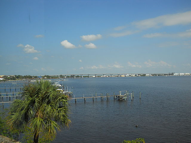
A lagoon does not have a typical river type current, their water is only moved by wind and a minor tidal flow. Earthen berm causeways contribute to the Indian River's health problems by impeding the lagoon's water flow, limiting it's ability to flush out stagnant water containing algae, bacteria, dead seagrass and pollutants. Recently the river's communities have recognized the harm these old berm bridges cause, and are requiring high rise bridges that span the entire river.
Bridge Info Table
Indian River Bridges and Causeways
Function: CargoSQLQuery::run Query: SELECT CONCAT( Name,' (info)') AS `Name`,`Road` AS `Road`,`County` AS `County`,CONCAT(FDOT) AS `FDOT`,`Description` AS `Description`,`Article` AS `Article` FROM `cargo__bridge` WHERE Water LIKE 'Indian River' ORDER BY CONCAT( Name,' (info)'),`Road`,`County`,CONCAT(FDOT),`Description` LIMIT 100
Bridge Info Box
No results
Indian River Bridges by County
Bridge Info Boxes
Brevard County
Haulover Canal Bridge
Haulover Canal Bridge | ||||
|---|---|---|---|---|
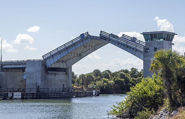 | ||||
| 1964 U.S. Army Corps of Engineers' Bascule double leaf drawbridge crossing Florida SR3 (N Courtney Parkway) over the Haulover Canal in the Merritt Island Wildlife Refuge. Article | ||||
| Waterway: Mosquito Lagoon | Road: SR3 | |||
| City: Allenhurst | County: Brevard | |||
| Type: Bascule Double Leaf | Builder:McCormick and Sons | |||
| DOT: 703004 | H: 27' | Built: 1964 | ||
Location: 28.73634,-80.75459
| ||||
| Number | 703004 |
| Route | 00000 |
| Place | |
| County | Brevard |
| Features | 'HAULOVER CANAL ' |
| Facility | 'COURTENAY PARKWAY ' |
| Location | '8.6 MILES SOUTH OF US 1 ' |
| Latitude | 28441095 |
| Longitude | 80451679 |
| Service On Roadway | Highway |
| Service Under Roadway | Waterway |
| Owner | NASA |
| Built | 1965 |
| Rebuilt | |
| Lanes | 2 |
| Lane Direction | 2 way |
| Direction | |
| Traffic | 675 |
| Traffic Year | 2016 |
| Future Traffic | |
| Future Traffic Year | |
| Length | 68m |
| Width | 10m |
| Clearance | |
| Kind | Steel |
| Type | Movable - Bascule |
| Deck Type | Open Grating |
| Critical | |
| Inspection Date (mm-yy) | 07-17 |
| Deck | Good |
| Superstructure | Fair |
| Substructure | Satisfactory |
| Channel | Bank protection is in need of minor repairs. River control devices and embankment protection have a little minor damage. Banks and/or channel have minor amounts of drift. |
| Culvert | N/A |
| Scour | Bridge foundations determined to be stable for assessed or calculated scour condition. Scour is determined to be within the limits of footing or piles (Example B) by assessment (i.e.,bridge foundations are on rock formations that have been determined to resist scour within the service life of the bridge), by calculations or by installation of properly designed countermeasures |
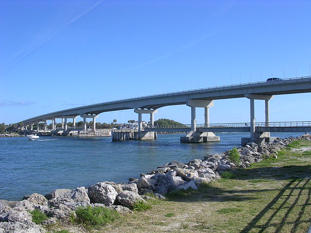
Max Brewer Bridge
Max Brewer Bridge | ||||
|---|---|---|---|---|
 | ||||
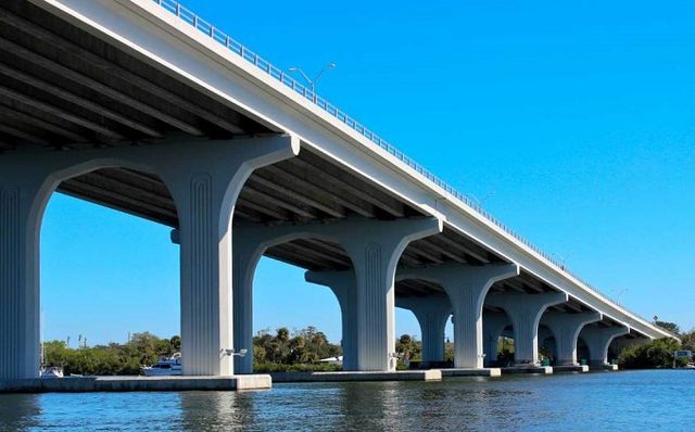
| Completed in 2010, the 3,207' long, 65' high A. Max Brewer Bridge connects the City of Titusville to Merritt Island providing access to the Kennedy Space Center via SR406. Includes a fishing pier and boat ramps on the west side and a 20' observation deck at the crest. This bridge is a good observation site for Kennedy Space Center, when it is closed to vehicle traffic. Article | ||||
| Waterway: North Indian River | Road: SR406 | |||
| City: Titusville | County: Brevard | |||
| Type: Segmental Span | Builder:DRMP | |||
| DOT: 700227 | L: 3,207' | H: 65' | Built: 2010 | |
Location: 28.61758,-80.80274
| ||||
| Number | 700227 |
| Route | 00406 |
| Place | Titusville |
| County | Brevard |
| Features | 'Indian River ' |
| Facility | 'SR-406 ' |
| Location | 'SR-406 over Indian River ' |
| Latitude | 28371291 |
| Longitude | 80475557 |
| Service On Roadway | Highway |
| Service Under Roadway | Waterway |
| Owner | FDOT |
| Built | 2010 |
| Rebuilt | |
| Lanes | 2 |
| Lane Direction | 2 way |
| Direction | |
| Traffic | 4000 |
| Traffic Year | 2016 |
| Future Traffic | 6940 |
| Future Traffic Year | 2038 |
| Length | 978m |
| Width | 17m |
| Clearance | |
| Kind | Prestressed concrete continuous |
| Type | Stringer/Multi-beam/Girder |
| Deck Type | Concrete Cast-in-Place |
| Critical | |
| Inspection Date (mm-yy) | 06-17 |
| Deck | Very Good |
| Superstructure | Good |
| Substructure | Very Good |
| Channel | Banks are protected or well vegetated. River control devices such as spur dikes and embankment protection are not required or are in a stable condition. |
| Culvert | N/A |
| Scour | Bridge foundations determined to be stable for assessed or calculated scour condition. Scour is determined to be within the limits of footing or piles (Example B) by assessment (i.e.,bridge foundations are on rock formations that have been determined to resist scour within the service life of the bridge), by calculations or by installation of properly designed countermeasures |
Sebastian Inlet Bridge
Sebastian Inlet Bridge | ||||
|---|---|---|---|---|
 | ||||
| The James H. Pruitt Memorial Bridge is a two lane segmental span bridge carrying A1A from Brevard County across the Sebastian Inlet to Indian River County. The first Sebastian Inlet Bridge was built in 1964 by Cleary Brothers Construction Company of West Palm Beach, Florida. Construction of a new replacement bridge will begin in 2026. Article | ||||
| Waterway: Central Indian River | Road: A1A | |||
| City: Indian River Oaks | County: Brevard | |||
| Type: Segmental Span | Builder:Cleary Brothers | |||
| DOT: 880005 | L: 1548' | H: 37' | Built: 1964 | |
Location: 27.86069, -80.44873
| ||||
Indian River County
Wabasso Bridge
Wabasso Bridge | ||||
|---|---|---|---|---|
 | ||||
| Wabasso Bridge is a two-lane concrete bridge spanning SR510 over the Indian River and Intracoastal Waterway in Indian River County, Florida. Article | ||||
| Waterway: Central Indian River | Road: SR510 | |||
| City: Wabasso | County: Indian River | |||
| Type: Concrete High Span | Builder:Scott Construction | |||
| DOT: 880051, 880053 | L: 1689.4' | H: 62.3' | Built: 1970 | |
Location: 27.75975,-80.41797
| ||||
Wabasso Causeway includes 4 bridges:
| Number | Water | Structure | Road | ||||||||||||||||||||||||||||||||||||||||||||||||||||||||||||||||||||||
|---|---|---|---|---|---|---|---|---|---|---|---|---|---|---|---|---|---|---|---|---|---|---|---|---|---|---|---|---|---|---|---|---|---|---|---|---|---|---|---|---|---|---|---|---|---|---|---|---|---|---|---|---|---|---|---|---|---|---|---|---|---|---|---|---|---|---|---|---|---|---|---|---|---|
| 880052 | Indian River | West Relief | SR510 | ||||||||||||||||||||||||||||||||||||||||||||||||||||||||||||||||||||||
| |||||||||||||||||||||||||||||||||||||||||||||||||||||||||||||||||||||||||
| Number | Water | Structure | Road | ||||||||||||||||||||||||||||||||||||||||||||||||||||||||||||||||||||||
|---|---|---|---|---|---|---|---|---|---|---|---|---|---|---|---|---|---|---|---|---|---|---|---|---|---|---|---|---|---|---|---|---|---|---|---|---|---|---|---|---|---|---|---|---|---|---|---|---|---|---|---|---|---|---|---|---|---|---|---|---|---|---|---|---|---|---|---|---|---|---|---|---|---|
| 880051 | Indian River | West Span | SR510 | ||||||||||||||||||||||||||||||||||||||||||||||||||||||||||||||||||||||
| |||||||||||||||||||||||||||||||||||||||||||||||||||||||||||||||||||||||||
| Number | Water | Structure | Road | ||||||||||||||||||||||||||||||||||||||||||||||||||||||||||||||||||||||
|---|---|---|---|---|---|---|---|---|---|---|---|---|---|---|---|---|---|---|---|---|---|---|---|---|---|---|---|---|---|---|---|---|---|---|---|---|---|---|---|---|---|---|---|---|---|---|---|---|---|---|---|---|---|---|---|---|---|---|---|---|---|---|---|---|---|---|---|---|---|---|---|---|---|
| 880053 | Indian River | East Span | SR510 | ||||||||||||||||||||||||||||||||||||||||||||||||||||||||||||||||||||||
| |||||||||||||||||||||||||||||||||||||||||||||||||||||||||||||||||||||||||
| Number | Water | Location | Road | ||||||||||||||||||||||||||||||||||||||||||||||||||||||||||||||||||||||
|---|---|---|---|---|---|---|---|---|---|---|---|---|---|---|---|---|---|---|---|---|---|---|---|---|---|---|---|---|---|---|---|---|---|---|---|---|---|---|---|---|---|---|---|---|---|---|---|---|---|---|---|---|---|---|---|---|---|---|---|---|---|---|---|---|---|---|---|---|---|---|---|---|---|
| 880050 | Indian River | East Relief | SR510 | ||||||||||||||||||||||||||||||||||||||||||||||||||||||||||||||||||||||
| |||||||||||||||||||||||||||||||||||||||||||||||||||||||||||||||||||||||||
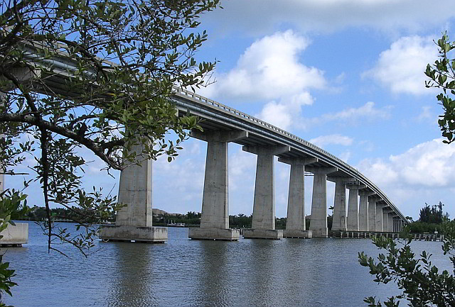
Alma Lee Loy Bridge
Alma Lee Loy Bridge | ||||
|---|---|---|---|---|
 | ||||
| Alma Lee Loy Bridge, commonly known as 17th Street Bridge, is a fixed concrete bridge that spans the Indian River intracoastal waterway in Indian River County, Florida. The bridge, started in 1977, was constructed by Gulf Contracting Inc, FL and completed in 1979. | ||||
| Waterway: Central Indian River | Road: CR656 | |||
| City: Vero Beach | County: Indian River | |||
| Type: Stringer/Multi-beam | ||||
| DOT: 880077 | L: 4730.9' | H: 62.3' | Built: 1979 | |
Location: 27.63221,-80.3691
| ||||
| Number | 880077 |
| Route | 00656 |
| Place | Vero Beach |
| County | Indian River |
| Features | 'Intracoastal Waterway ' |
| Facility | 'SR-656 (17th St.) ' |
| Location | '0.4 Mi. W of SR-A1A ' |
| Latitude | 27375640 |
| Longitude | 80221680 |
| Service On Roadway | Highway |
| Service Under Roadway | Waterway |
| Owner | FDOT |
| Built | 1979 |
| Rebuilt | |
| Lanes | 4 |
| Lane Direction | 2 way |
| Direction | |
| Traffic | 19400 |
| Traffic Year | 2016 |
| Future Traffic | 33659 |
| Future Traffic Year | 2038 |
| Length | 1442m |
| Width | 26m |
| Clearance | |
| Kind | Prestressed concrete |
| Type | Stringer/Multi-beam/Girder |
| Deck Type | Concrete Precast Panels |
| Critical | |
| Inspection Date (mm-yy) | 03-17 |
| Deck | Satisfactory |
| Superstructure | Satisfactory |
| Substructure | Good |
| Channel | Bank protection is in need of minor repairs. River control devices and embankment protection have a little minor damage. Banks and/or channel have minor amounts of drift. |
| Culvert | N/A |
| Scour | Bridge is scour critical; bridge foundations determined to be unstable for assessed or calculated scour conditions: Scour within limits of footing or piles. Scour below spread-footing base or pile tips. |
Merrill Barber Bridge
Merrill Barber Bridge | ||||
|---|---|---|---|---|
 | ||||
| The Merrill Barber Bridge is a concrete arch bridge that spans SR60 over the Indian River in Indian River County, Florida. Article | ||||
| Waterway: Central Indian River | Road: SR60 | |||
| City: Vero Beach | County: Indian River | |||
| Type: concrete arch | Builder:Odebrecht | |||
| DOT: 880087 | L: 3834.2' | H: 62.3' | Built: 1995 | |
Location: 27.65293,-80.37329
| ||||
| Number | Water | Structure | Road | ||||||||||||||||||||||||||||||||||||||||||||||||||||||||||||||||||||||
|---|---|---|---|---|---|---|---|---|---|---|---|---|---|---|---|---|---|---|---|---|---|---|---|---|---|---|---|---|---|---|---|---|---|---|---|---|---|---|---|---|---|---|---|---|---|---|---|---|---|---|---|---|---|---|---|---|---|---|---|---|---|---|---|---|---|---|---|---|---|---|---|---|---|
| 880087 | Indian River | Main Span | SR60 | ||||||||||||||||||||||||||||||||||||||||||||||||||||||||||||||||||||||
| |||||||||||||||||||||||||||||||||||||||||||||||||||||||||||||||||||||||||
Martin County
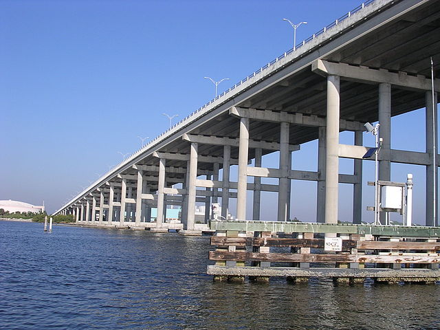
Roosevelt Bridge
Roosevelt Bridge | ||||
|---|---|---|---|---|
 | ||||
| The Roosevelt Bridge is a major highway segmental bridge across the St. Lucie River in Stuart, Florida. Carrying U.S. Route 1, it was built to supersede the old Roosevelt Bridge, which had twin parallel drawbridges, one for northbound traffic and the other for southbound. | ||||
| Waterway: Saint Lucie River | Road: US1 | |||
| City: Stuart | County: Martin | |||
| Type: Segmental Span | Builder:Finley | |||
| DOT: 890151 | L: 2982.8' | H: 62.3' | Built: 1996 | |
Location: 27.20672,-80.25854
| ||||
Roosevelt Bridge has two spans:
| Number | Water | Location | Road | ||||||||||||||||||||||||||||||||||||||||||||||||||||||||||||||||||||||
|---|---|---|---|---|---|---|---|---|---|---|---|---|---|---|---|---|---|---|---|---|---|---|---|---|---|---|---|---|---|---|---|---|---|---|---|---|---|---|---|---|---|---|---|---|---|---|---|---|---|---|---|---|---|---|---|---|---|---|---|---|---|---|---|---|---|---|---|---|---|---|---|---|---|
| 890151 | Indian River | Southbound Span | SR407 | ||||||||||||||||||||||||||||||||||||||||||||||||||||||||||||||||||||||
| |||||||||||||||||||||||||||||||||||||||||||||||||||||||||||||||||||||||||
| Number | Water | Location | Road | ||||||||||||||||||||||||||||||||||||||||||||||||||||||||||||||||||||||
|---|---|---|---|---|---|---|---|---|---|---|---|---|---|---|---|---|---|---|---|---|---|---|---|---|---|---|---|---|---|---|---|---|---|---|---|---|---|---|---|---|---|---|---|---|---|---|---|---|---|---|---|---|---|---|---|---|---|---|---|---|---|---|---|---|---|---|---|---|---|---|---|---|---|
| 890152 | Indian River | Northbound Span | SR407 | ||||||||||||||||||||||||||||||||||||||||||||||||||||||||||||||||||||||
| |||||||||||||||||||||||||||||||||||||||||||||||||||||||||||||||||||||||||
Ernest Lyons Bridge
Ernest Lyons Bridge | ||||
|---|---|---|---|---|
 | ||||
| The new Ernest F. Lyons Bridge is a 4600-ft-long, 31-span, two-lane, precast segmental bridge built using the span-by-span method of construction. | ||||
| Waterway: South Indian River | Road: A1A | |||
| City: Sewell's Point | County: Martin | |||
| Type: Segmental Span | Builder:Corven Engineering | |||
| DOT: 890158 | L: 4600' | H: 62.3' | Built: 2008 | |
Location: 27.20644,-80.19229
| ||||
| Number | 890158 |
| Route | 00A1A |
| Place | Stuart |
| County | Martin |
| Features | 'St.Lucie River ' |
| Facility | 'E/B S.R. A1A ' |
| Location | '3mi East of SR5 on A1A ' |
| Latitude | 27115581 |
| Longitude | 80122859 |
| Service On Roadway | Highway - Pedestrian |
| Service Under Roadway | Waterway |
| Owner | FDOT |
| Built | 2001 |
| Rebuilt | |
| Lanes | 2 |
| Lane Direction | 1 way |
| Direction | |
| Traffic | 12500 |
| Traffic Year | 2017 |
| Future Traffic | 21688 |
| Future Traffic Year | 2039 |
| Length | 909m |
| Width | 15m |
| Clearance | |
| Kind | Prestressed concrete continuous |
| Type | Segmental box girder |
| Deck Type | Concrete Cast-in-Place |
| Critical | |
| Inspection Date (mm-yy) | 06-17 |
| Deck | Good |
| Superstructure | Very Good |
| Substructure | Good |
| Channel | No noticeable or noteworthy deficiencies which affect the condition of the channel. |
| Culvert | N/A |
| Scour | Bridge foundations determined to be stable for the assessed or calculated scour condition. Scour is determined to be above top of footing (Example A) by assessment (i.e., bridge foundations are on rock formations that have been determined to resist scour within the service life of the bridge4), by calculation or by installation of properly designed countermeasures |
-->