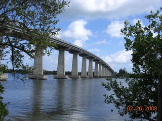
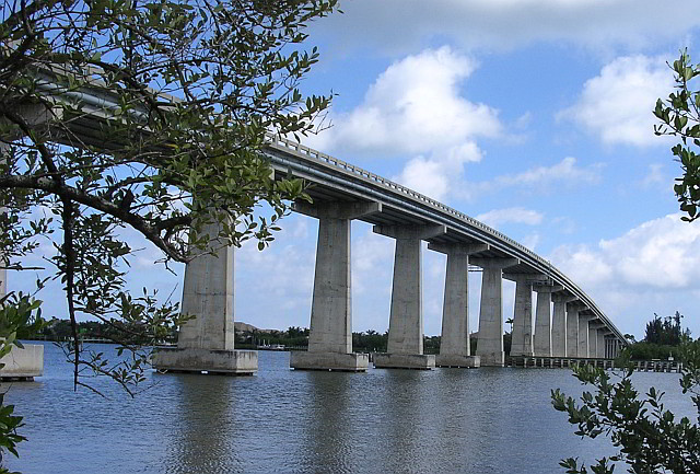
A 1,689.4' long stringer bridge spanning SR510 over the Indian River in Vero Beach, Indian River County, Florida
Wabasso Bridge, SR510, Indian River County
The Wabasso Causeway Bridge is a two-lane concrete bridge spanning the Indian River (Intracoastal Waterway) in Indian River County, Florida. The two-lane bridge has a vertical clearance of 65 feet (20 m). The bridge was built by Scott Construction Company and was completed in 1970. The Florida Department of Transportation numbers are 880051 and 880053.
Wabasso Bridge is a two-lane concrete bridge spanning SR510 over the Indian River and Intracoastal Waterway in Indian River County, Florida. Article
Waterway: Central Indian River
Road: SR510
City: Wabasso
County: Indian River
Type: Concrete High Span
Builder:Scott Construction
DOT: 880051, 880053
L: 1689.4'
H: 62.3'
Built: 1970
Location: 27.75975,-80.41797
Wabasso Causeway includes 4 bridges:
Number
Water
Structure
Road
880052
Indian River
West Relief
SR510
National Bridge Data
Number
880052
Route
00510
Place
74625
County
Indian River
Features
'Indian River Relief '
Facility
'SR510 Wabasso Road'
Location
'0.5Mi East of US-1 '
Latitude
27451178
Longitude
80254429
Service On Roadway
Highway - Pedestrian
Service Under Roadway
Waterway Relief
Owner
FDOT
Built
1967
Rebuilt
Lanes
2
Lane Direction
2 way
Direction
Traffic
13300
Traffic Year
2016
Future Traffic
23076
Future Traffic Year
2038
Length
61m
Width
12m
Clearance
Kind
Prestressed concrete
Type
Stringer/Multi-beam/Girder
Deck Type
Concrete Cast-in-Place
Critical
Inspection Date (mm-yy)
11-17
Deck
Good
Superstructure
Good
Substructure
Good
Channel
Bank is beginning to slump. River control devices and embankment protection have widespread minor damage. There is minor stream bed movement evident. Debris is restricting the channel slightly.
Culvert
N/A
Scour
Bridge foundations determined to be stable for the assessed or calculated scour condition. Scour is determined to be above top of footing (Example A) by assessment (i.e., bridge foundations are on rock formations that have been determined to resist scour within the service life of the bridge4), by calculation or by installation of properly designed countermeasures
Number
Water
Structure
Road
880051
Indian River
West Span
SR510
National Bridge Data
Number
880051
Route
00510
Place
74625
County
Indian River
Features
'Indian River '
Facility
'SR-510 Wabasso Rd '
Location
'0.7Mi East of US-1 '
Latitude
27452066
Longitude
80252909
Service On Roadway
Highway - Pedestrian
Service Under Roadway
Waterway
Owner
FDOT
Built
1967
Rebuilt
Lanes
2
Lane Direction
2 way
Direction
Traffic
13300
Traffic Year
2016
Future Traffic
23076
Future Traffic Year
2038
Length
412m
Width
12m
Clearance
Kind
Prestressed concrete
Type
Stringer/Multi-beam/Girder
Deck Type
Concrete Cast-in-Place
Critical
Inspection Date (mm-yy)
11-17
Deck
Satisfactory
Superstructure
Satisfactory
Substructure
Satisfactory
Channel
Bank protection is in need of minor repairs. River control devices and embankment protection have a little minor damage. Banks and/or channel have minor amounts of drift.
Culvert
N/A
Scour
Bridge foundations determined to be stable for the assessed or calculated scour condition. Scour is determined to be above top of footing (Example A) by assessment (i.e., bridge foundations are on rock formations that have been determined to resist scour within the service life of the bridge4), by calculation or by installation of properly designed countermeasures
Number
Water
Structure
Road
880053
Indian River
East Span
SR510
National Bridge Data
Number
880053
Route
00510
Place
74625
County
Indian River
Features
'Intracoastal Waterway '
Facility
'SR-510(Wabasso Rd)'
Location
'1.4MI E OF US-1 '
Latitude
27453510
Longitude
80250470
Service On Roadway
Highway
Service Under Roadway
Waterway
Owner
FDOT
Built
1970
Rebuilt
Lanes
2
Lane Direction
2 way
Direction
Traffic
13300
Traffic Year
2016
Future Traffic
23076
Future Traffic Year
2038
Length
515m
Width
11m
Clearance
Kind
Prestressed concrete
Type
Stringer/Multi-beam/Girder
Deck Type
Concrete Cast-in-Place
Critical
Inspection Date (mm-yy)
12-17
Deck
Satisfactory
Superstructure
Good
Substructure
Good
Channel
Bank protection is in need of minor repairs. River control devices and embankment protection have a little minor damage. Banks and/or channel have minor amounts of drift.
Culvert
N/A
Scour
Bridge foundations determined to be stable for the assessed or calculated scour condition. Scour is determined to be above top of footing (Example A) by assessment (i.e., bridge foundations are on rock formations that have been determined to resist scour within the service life of the bridge4), by calculation or by installation of properly designed countermeasures
Number
Water
Location
Road
880050
Indian River
East Relief
SR510
National Bridge Data
Number
880050
Route
00510
Place
74625
County
Indian River
Features
'Indian River '
Facility
'SR510 Wabasso Road'
Location
'1.2MI East of US-1 '
Latitude
27452951
Longitude
80251396
Service On Roadway
Highway - Pedestrian
Service Under Roadway
Waterway
Owner
FDOT
Built
1967
Rebuilt
Lanes
2
Lane Direction
2 way
Direction
Traffic
13300
Traffic Year
2016
Future Traffic
23076
Future Traffic Year
2038
Length
61m
Width
12m
Clearance
Kind
Prestressed concrete
Type
Stringer/Multi-beam/Girder
Deck Type
Concrete Cast-in-Place
Critical
Inspection Date (mm-yy)
11-17
Deck
Good
Superstructure
Good
Substructure
Satisfactory
Channel
Bank protection is in need of minor repairs. River control devices and embankment protection have a little minor damage. Banks and/or channel have minor amounts of drift.
Culvert
N/A
Scour
Bridge foundations determined to be stable for the assessed or calculated scour condition. Scour is determined to be above top of footing (Example A) by assessment (i.e., bridge foundations are on rock formations that have been determined to resist scour within the service life of the bridge4), by calculation or by installation of properly designed countermeasures
History
Old Wabasso Bridge, Vero, Indian River County
Until 1920, there were only two bridges spanning across the Indian River, one in Brevard County's Cocoa and the second in Martin County's Hobe Sound. On Labor Day in 1920, a new wooden Vero Bridge opened and access to the ocean was available to all who lived on the Vero mainland. For boat traffic, a bridge tender, who lived in a house near the middle of the crossing, would open the metal swing span by hand. Tolls were charged to cross the bridge, ranging from 5 cents for pedestrians, 10 cents for horses and 35 cents for delivery trucks.[1]
Source: National Bridge Inventory. Information not verified; use at your own risk.
Name:
CR-510 WABASSO RD over CANAL
Structure number:
880047
Location:
3MI W OF CR-615
Purpose:
Carries highway over waterway
Route classification:
Other Principal Arterial (Urban) [14]
Length of largest span:
15.1 ft. [4.6 m]
Total length:
60.0 ft. [18.3 m]
Roadway width between curbs:
40.0 ft. [12.2 m]
Deck width edge-to-edge:
42.0 ft. [12.8 m]
Owner:
County Highway Agency [02]
Year built:
1951
Year reconstructed:
1968
Historic significance:
Bridge is not eligible for the National Register of Historic Places [5]
Design load:
MS 13.5 / HS 15 [3]
Number of main spans:
4
Main spans material:
Concrete [1]
Main spans design:
Slab [01]
Deck type:
Concrete Cast-in-Place [1]
Wearing surface:
Bituminous [6]
Inspection Report
Latest Available Inspection: October 2017
Good/Fair/Poor Condition:
Fair
Status:
Open, no restriction [A]
Average daily traffic:
5,500 [as of 2017]
Truck traffic:
8% of total traffic
Deck condition:
Good [7 out of 9]
Superstructure condition:
Good [7 out of 9]
Substructure condition:
Satisfactory [6 out of 9]
Structural appraisal:
Somewhat better than minimum adequacy to tolerate being left in place as is [5]
Deck geometry appraisal:
Somewhat better than minimum adequacy to tolerate being left in place as is [5]
Water adequacy appraisal:
Better than present minimum criteria [7]
Roadway alignment appraisal:
Equal to present minimum criteria [6]
Channel protection:
Bank is beginning to slump. River control devices and embankment protection have widespread minor damage. There is minor stream bed movement evident. Debris is restricting the channel slightly. [6]
Scour condition:
Bridge foundations determined to be stable for the assessed or calculated scour condition. [8]
Sufficiency rating:
81.9
InspectionHistory
Date
Condition
Deck
Superstructure
Substructure
ADT
Suff. Rating
October 2017
Fair
Good
Good
Satisfactory
5500
81.9
October 2015
Fair
Good
Good
Satisfactory
5500
81.9
October 2013
Fair
Good
Good
Satisfactory
5500
81.9
October 2011
Fair
Good
Good
Satisfactory
5500
81.9
October 2009
Fair
Good
Good
Satisfactory
5500
81.9
November 2007
Fair
Good
Good
Satisfactory
5500
81.9
November 2005
Fair
Good
Good
Satisfactory
5500
80.9
November 2003
Fair
Good
Good
Satisfactory
5500
80.9
February 2002
Fair
Good
Good
Satisfactory
5500
80.9
February 2000
Fair
Good
Good
Satisfactory
5100
81.0
February 1998
Fair
Good
Good
Satisfactory
5100
80.1
February 1996
Fair
Good
Good
Satisfactory
5100
81.0
January 1994
Fair
Good
Good
Satisfactory
5100
82.0
January 1992
Fair
Good
Good
Satisfactory
3000
84.4
Element Data
Source: National Bridge Elements dataset, 2018 edition. This feature is experimental.