Geological History: Difference between revisions
mNo edit summary |
mNo edit summary |
||
| (One intermediate revision by the same user not shown) | |||
| Line 4: | Line 4: | ||
The Florida peninsula had its origins in the creation of the super continent of Pangaea some 300 million years ago (mya) when the North American continental land mass, which was part of the super continent called Euramerica, collided with the northwest edge of the African continental plate, which was part of the super continent called Gondwana. | The Florida peninsula had its origins in the creation of the super continent of Pangaea some 300 million years ago (mya) when the North American continental land mass, which was part of the super continent called Euramerica, collided with the northwest edge of the African continental plate, which was part of the super continent called Gondwana. | ||
This continental collision produced faulting and uplifting to form the Appalachian mountain range along the eastern edge of the North American plate. The base material below the Floridan Plateau is very similar to that found along the northern coast of Africa (Hine, 2013).<ref name=Hine2013 /> | This continental collision produced faulting and uplifting to form the Appalachian mountain range along the eastern edge of the North American plate. The base material below the Floridan Plateau is very similar to that found along the northern coast of Africa (Hine, 2013).<ref name=Hine2013 /> | ||
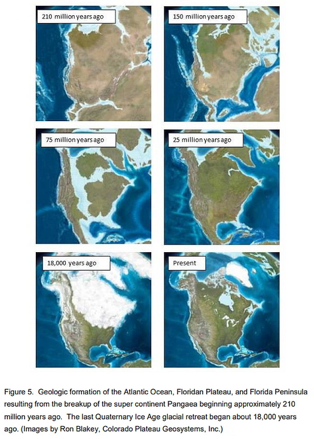
During the late Triassic and early Jurassic period, some 200 to 180 mya, tectonic plate movement began rifting Pangaea to create the Atlantic Ocean between America and Africa (Figure 5). | During the late Triassic and early Jurassic period, some 200 to 180 mya, tectonic plate movement began rifting Pangaea to create the Atlantic Ocean between America and Africa (Figure 5). | ||
As the 16 continents spread, the Florida shelf attached and moved with the southern edge of the North American Continent in the area now known as the state of Georgia (Hine, 2013).<ref name=Hine2013 | As the 16 continents spread, the Florida shelf attached and moved with the southern edge of the North American Continent in the area now known as the state of Georgia (Hine, 2013).<ref name=Hine2013 /> | ||
[[File:Geological_History_figure_5_web.jpg|alt=Geologic formation of the Atlantic Ocean, Floridan Plateau, and Florida Peninsula|border|frameless|640px]] | [[File:Geological_History_figure_5_web.jpg|alt=Geologic formation of the Atlantic Ocean, Floridan Plateau, and Florida Peninsula.|border|frameless|640px|Geologic formation of the Atlantic Ocean, Floridan Plateau, and Florida Peninsula.]] | ||
As the plates continued to move apart the passive margin of the North America plate subsided and the Floridan Plateau began to form through deposition of thousands of meters of sediments. These sediments included materials eroded from the Appalachian Mountains and coastal lowlands of eastern North America, and deposition of marine carbonate materials in the form of coral reefs, shells, and limy muds (Hine, 2013).<ref name=Hine2013 /> | As the plates continued to move apart the passive margin of the North America plate subsided and the Floridan Plateau began to form through deposition of thousands of meters of sediments. These sediments included materials eroded from the Appalachian Mountains and coastal lowlands of eastern North America, and deposition of marine carbonate materials in the form of coral reefs, shells, and limy muds (Hine, 2013).<ref name=Hine2013 /> | ||
| Line 21: | Line 20: | ||
[[File:Geological_History_Table_4_web.jpg|alt=Known ice ages and associated geologic time periods|border|frameless|640px]] | [[File:Geological_History_Table_4_web.jpg|alt=Known ice ages and associated geologic time periods|border|frameless|640px]] | ||
During the Quaternary ice age, repeated glacial and interglacial periods of the northern hemisphere produced dramatic fluctuations in sea level (Bowen, 1978).<ref name=Bowen1978 | During the Quaternary ice age, repeated glacial and interglacial periods of the northern hemisphere produced dramatic fluctuations in sea level (Bowen, 1978).<ref name=Bowen1978 /> At the maximum of the Wisconsin glaciation (ca. 18,000 years B.P.), sea levels were on the order of 100 m lower than at present, and substantial additional areas of Florida were exposed along the Atlantic and Gulf coasts (Field and Duane, 1974; Delcourt and Delcourt, 1981).<ref name=Delcourt1981 /> | ||
The outer barrier island and Cape Canaveral formed after sea levels rose as the Wisconsin glaciers retreated (Davis, 1997). | The outer barrier island and Cape Canaveral formed after sea levels rose as the Wisconsin glaciers retreated (Davis, 1997). | ||
Cape Canaveral is mapped as Holocene in age suggesting that formation of the barrier island complex began about 7,000 years ago (Brooks, 1972, 1981).<ref name=Brooks1971 | Cape Canaveral is mapped as Holocene in age suggesting that formation of the barrier island complex began about 7,000 years ago (Brooks, 1972, 1981).<ref name=Brooks1971 /><ref name=Brooks1981 /> Cape Canaveral is part of a prograding barrier island complex, the result of southward growth of an original cape at the site of the present False Cape (White, 1958, 1970).<ref name=White1958 /><ref name=White1970 /> | ||
Multiple dune ridges on Merritt Island and Cape Canaveral indicate periods of deposition and erosion alternating as sea level varied in height (Chaki, 1974).<ref name=Chaki1974 | Multiple dune ridges on Merritt Island and Cape Canaveral indicate periods of deposition and erosion alternating as sea level varied in height (Chaki, 1974).<ref name=Chaki1974 /> | ||
The barrier island separating Mosquito Lagoon from the Atlantic Ocean also originated about 7,000 years ago (Mehta and Brooks, 1973).<ref name=MehtaandBrooks1973 | The barrier island separating Mosquito Lagoon from the Atlantic Ocean also originated about 7,000 years ago (Mehta and Brooks, 1973).<ref name=MehtaandBrooks1973 /> However, its history has been marked by erosion, overwash, and landward migration rather than progradation (Mehta and Brooks, 1973).<ref name=MehtaandBrooks1973 /> | ||
</div> | </div> | ||
<div class="irlcontentbottom"> | <div class="irlcontentbottom"> | ||
| Line 37: | Line 35: | ||
==References== | ==References== | ||
<references /> | <references> | ||
<ref name=Hine2013>Hine, A.C. 2013. The geologic history of Florida—the major events of the past that shaped the sunshine state, Gainesville, FL, The University Press of Florida.</ref> | |||
<ref name=Bowen1978>Bowen, D. Q. 1978. Quaternary geology: a stratigraphic framework for multidisciplinary work. Pergamon Press. New York. 221p.</ref> | |||
<ref name=Delcourt1981>Delcourt, P. A. and H. R. Delcourt. 1981. Vegetation maps for eastern North America:40,000 Yr. B.P. to the present. p.123-165. In: R.C. Romans (ed.). Geobotany II. Plenum Publishing Corporation.</ref> | |||
<ref name=Brooks1971>Brooks, H. K. 1972. Geology of Cape Canaveral. p. 35-44. In: T.E. Garner (ed.). Space-age geology. Southeastern Geology Society. Tallahassee, Florida.</ref> | |||
<ref name=Brooks1981>Brooks, H. K. 1981. Geologic map of Florida. Florida Cooperative Extension Service, Institute of Food and Agricultural Sciences, University of Florida. Gainesville.</ref> | |||
<ref name=White1958>White, W. A. 1958. Some geomorphic features of central peninsular Florida. Geological Bulletin No. 41. Florida Geological Survey. Tallahassee. 92p.</ref> | |||
<ref name=White1970>White, W. A . 1970. The geomorphology of the Florida peninsula. Geological Bulletin No.51. Bureau of Geology, Florida Department of Natural Resources, Tallahassee. 164 pp.</ref> | |||
<ref name=Chaki1974>Chaki, S. 1974. Study of beach ridges, Cape Canaveral, Florida. Coastal Research Notes 4(2):5-7.</ref> | |||
<ref name=MehtaandBrooks1973>Mehta, A. J. and H. K. Brooks. 1973. Mosquito Lagoon barrier beach study. Shore and Beach 41 (2):26-34.</ref> | |||
</references> | |||
{{IRL footer estuary|cat=History}} | {{IRL footer estuary|cat=History}} | ||
</div></div> | </div></div> | ||
[[Category:History]] | [[Category:History]] | ||
Latest revision as of 19:19, November 22, 2021
The Florida peninsula had its origins in the creation of the super continent of Pangaea some 300 million years ago (mya) when the North American continental land mass, which was part of the super continent called Euramerica, collided with the northwest edge of the African continental plate, which was part of the super continent called Gondwana.
This continental collision produced faulting and uplifting to form the Appalachian mountain range along the eastern edge of the North American plate. The base material below the Floridan Plateau is very similar to that found along the northern coast of Africa (Hine, 2013).[1]
During the late Triassic and early Jurassic period, some 200 to 180 mya, tectonic plate movement began rifting Pangaea to create the Atlantic Ocean between America and Africa (Figure 5).
As the 16 continents spread, the Florida shelf attached and moved with the southern edge of the North American Continent in the area now known as the state of Georgia (Hine, 2013).[1]
As the plates continued to move apart the passive margin of the North America plate subsided and the Floridan Plateau began to form through deposition of thousands of meters of sediments. These sediments included materials eroded from the Appalachian Mountains and coastal lowlands of eastern North America, and deposition of marine carbonate materials in the form of coral reefs, shells, and limy muds (Hine, 2013).[1]
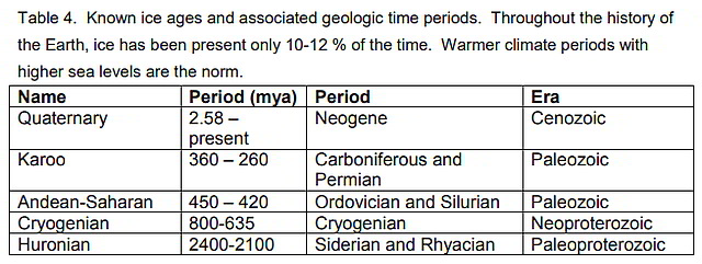
The major driving force in the creation of the modern Florida landscape has been the influence of the last Ice Age and its repeating glacial and inter-glacial periods.
Throughout Earth’s 4.6 billion year history geologists have identified five significant Ice Ages or periods lasting a total of approximately 500 million years (Table 4).
During the Quaternary ice age, repeated glacial and interglacial periods of the northern hemisphere produced dramatic fluctuations in sea level (Bowen, 1978).[2] At the maximum of the Wisconsin glaciation (ca. 18,000 years B.P.), sea levels were on the order of 100 m lower than at present, and substantial additional areas of Florida were exposed along the Atlantic and Gulf coasts (Field and Duane, 1974; Delcourt and Delcourt, 1981).[3]
The outer barrier island and Cape Canaveral formed after sea levels rose as the Wisconsin glaciers retreated (Davis, 1997).
Cape Canaveral is mapped as Holocene in age suggesting that formation of the barrier island complex began about 7,000 years ago (Brooks, 1972, 1981).[4][5] Cape Canaveral is part of a prograding barrier island complex, the result of southward growth of an original cape at the site of the present False Cape (White, 1958, 1970).[6][7]
Multiple dune ridges on Merritt Island and Cape Canaveral indicate periods of deposition and erosion alternating as sea level varied in height (Chaki, 1974).[8]
The barrier island separating Mosquito Lagoon from the Atlantic Ocean also originated about 7,000 years ago (Mehta and Brooks, 1973).[9] However, its history has been marked by erosion, overwash, and landward migration rather than progradation (Mehta and Brooks, 1973).[9]
Documents
References
- ↑ 1.0 1.1 1.2 Hine, A.C. 2013. The geologic history of Florida—the major events of the past that shaped the sunshine state, Gainesville, FL, The University Press of Florida.
- ↑ Bowen, D. Q. 1978. Quaternary geology: a stratigraphic framework for multidisciplinary work. Pergamon Press. New York. 221p.
- ↑ Delcourt, P. A. and H. R. Delcourt. 1981. Vegetation maps for eastern North America:40,000 Yr. B.P. to the present. p.123-165. In: R.C. Romans (ed.). Geobotany II. Plenum Publishing Corporation.
- ↑ Brooks, H. K. 1972. Geology of Cape Canaveral. p. 35-44. In: T.E. Garner (ed.). Space-age geology. Southeastern Geology Society. Tallahassee, Florida.
- ↑ Brooks, H. K. 1981. Geologic map of Florida. Florida Cooperative Extension Service, Institute of Food and Agricultural Sciences, University of Florida. Gainesville.
- ↑ White, W. A. 1958. Some geomorphic features of central peninsular Florida. Geological Bulletin No. 41. Florida Geological Survey. Tallahassee. 92p.
- ↑ White, W. A . 1970. The geomorphology of the Florida peninsula. Geological Bulletin No.51. Bureau of Geology, Florida Department of Natural Resources, Tallahassee. 164 pp.
- ↑ Chaki, S. 1974. Study of beach ridges, Cape Canaveral, Florida. Coastal Research Notes 4(2):5-7.
- ↑ 9.0 9.1 Mehta, A. J. and H. K. Brooks. 1973. Mosquito Lagoon barrier beach study. Shore and Beach 41 (2):26-34.


