Haulover Canal: Difference between revisions
mNo edit summary |
mNo edit summary |
||
| (60 intermediate revisions by the same user not shown) | |||
| Line 1: | Line 1: | ||
< | <div class="irlbody irlbow"> | ||
[[File: | {{IRL header estuary|cat=Water Body}} | ||
<div class="irlcontenttop"> | |||
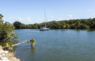
[[File:Haulover_Canal.jpg|320px|thumb|right|alt=Sailboat on Haulover Canal|Sailboat on Haulover Canal]] | |||
<section begin=about /> | |||
Located in the former Allenhurst community, [[Haulover Canal]] cuts through the northern end of Brevard County's Merritt Island to connect [[Mosquito Lagoon]] with the [[Indian River]]. | |||
Situated in [[Merritt Island National Refuge]], | Situated in [[Merritt Island National Wildlife Refuge]], Haulover Canal's shorelines are maintained by the [[United States Fish and Wildlife Service]] (FWS). Open to the public during daylight hours only, the canal's shoreline is a nature lover's paradise. The canal offers a Manatee Watch Station, boat ramps, day hiking, picnic and fishing areas. It is a preferred launching area for kayakers, canoeists and anglers heading for [[Mosquito Lagoon]]. As part of the Intracoastal Waterway, the canal sees a steady parade of watercraft, shipping barges, yachts, sailboats and fishing boats of all sizes throughout the day. | ||
<section end=about /> | |||
</div> | |||
<div class="irlcontentmiddle"> | |||
==History== | |||
[[File:Merritt Island Haulover canal sign02.jpg|320px|thumb|right|alt=Haulover Canal Historical Marker|Haulover Canal Historical Marker]] | |||
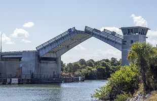
In 1887 Florida Coast Line Canal and Transportation Co. dug the current Haulover Canal, moving it south of the historic "Old Haulover" canal. In 1927, the canal was assigned to the U.S. Army Corps of Engineering, who widened and deepened the canal channel for use in the Intracoastal Waterway system. In 1964 The Army Corps built a new Bascule double leaf bridge. | |||
In 1978, the National Park Service recognized Haulover Canal as a historic place worthy of preservation in it's National Register of Historic Places (listing #78000262 ).<ref name=nrhp /> The Historical Marker<ref name=hmdb /> is located near [[Info:Haulover Canal Bridge|Haulover Canal Bridge]]. | |||
===Historical Marker Text=== | |||
''Native Americans, explorers and settlers hauled or carried canoes and small boats over this narrow strip of land between Mosquito Lagoon and the Indian River. Eventually it became known as the “haulover.” Connecting both bodies of water had long plagued early settlers of this area. Spaniards visited as early as 1605 and slid boats over the ground covered with mulberry tree bark. Early settlers used rollers and skids to drag schooners across. Fort Ann was established nearby in 1837, during the 2nd Seminole War (1835-1842), to protect the haulover from Indians and carry military supplies from the lagoon to the river. In 1852, contractor G.E. Hawes dug the first canal using slave labor. It was 3 ft. deep, 14 ft. wide, and completed in time for the 3rd Seminole War (1856-1858). Steamboat and cargo ships used the passage until the railroad arrived in 1885.'' | |||
''By 1887, the Florida Coast Line Canal and Transportation Co. dug a new and deeper canal which you see now, a short distance from the original. The Intracoastal Waterway incorporated the Haulover Canal as a federal project in 1927 to be maintained by the U.S. Army Corps of Engineers. In 1964 a concrete and steel double leaf Bascule drawbridge was constructed at North Courtney Parkway (CR3).'' | |||
</div> | |||
<div class="irlcontentmiddle"> | |||
{{Bridge Query|like=Haulover Canal Bridge}} | |||
</div> | |||
<div class="irlcontentmiddle irlvideo"> | |||
==Video== | |||
Select a video to play or visit the [https://www.youtube.com/channel/UCHtV0jOmRQMpJEtUXfIjAbA Indian River Lagoon Project YouTube Channel]. | |||
= | {{#evl:eOS8oAnFJMg|Discover Brevard - Haulover Canal|1|player=youtube}} | ||
Haulover Canal | <br />{{#evl:XLnicRE2zzk|Haulover Canal Manatee Family|2|player=youtube}} | ||
== | <evlplayer w="340" h="220" id="youtube" style="width:inherit;">https://img.youtube.com/vi/eOS8oAnFJMg/0.jpg</evlplayer> | ||
</div> | |||
<div class="irlcontentmiddle irlgallery"> | |||
<div | ==Image Gallery== | ||
== | |||
[[File:Haulover Canal - Flickr - Rusty Clark (49).jpg|320px|thumb|right|Haulover Canal - Rusty Clark]] | [[File:Haulover Canal - Flickr - Rusty Clark (49).jpg|320px|thumb|right|Haulover Canal - Rusty Clark]] | ||
[[File:Merritt Island Haulover canal bridge01.jpg|320px|thumb|left|Merritt Island Haulover Canal]] | [[File:Merritt Island Haulover canal bridge01.jpg|320px|thumb|left|Merritt Island Haulover Canal]] | ||
</div> | </div> | ||
<div class="irlcontentbottom"> | |||
==Web Links== | |||
* [https://news.google.com/newspapers?id=M9IhAAAAIBAJ&sjid=v54FAAAAIBAJ&pg=6477%2C421147 Daytona Beach Morning Journal: Haulover Bridge Contract Let, 1964] | |||
* [https://nbbd.com/godo/history/Haulover-Canal/index.html History of Haulover Canal] | |||
* [https://environmental.ksc.nasa.gov/EnvironmentalPlanning/CulturalResources/Haulover KSC Cultural Resources: Recordation: Haulover Canal Bridge] | |||
* [https://images.nasa.gov/search-results?q=haulover%20canal&page=1&media=image,video,audio&yearStart=1920&yearEnd=2019 NASA Haulover Photo Gallery] | |||
* [https://public.myfwc.com/LE/boatramp/public/Ramp.aspx?FacilityID=BV70020KU&Name=Merritt+Island+National+Wildlife+Refuge+-+Bairs+Cove FWC Haulover Canal (Bairs Cove) Boat Ramp] | |||
* [http://bridgereports.com/1646989 Haulover Bridge Inspection Report] | |||
* [https://waterdata.usgs.gov/usa/nwis/uv?site_no=02248380 USGS Haulover Canal Water Quality Report] | |||
==References== | ==References== | ||
<references> | |||
<ref name=nrhp>[https://www.nps.gov/subjects/nationalregister/index.htm National Register of Historic Places]</ref> | |||
<ref name=hmdb>[https://www.hmdb.org/marker.asp?marker=108012 Haulover Canal Historical Marker]</ref> | |||
</references> | |||
</div> | |||
{{IRL footer estuary|cat=Water Body}} | |||
</div> | |||
[[Category:Indian River Water Body]] | [[Category:Indian River Water Body]] | ||
[[Category:Mosquito Lagoon Water Body]] | [[Category:Mosquito Lagoon Water Body]] | ||
[[Category:Historical Site]] | |||
Latest revision as of 14:19, December 26, 2021
Located in the former Allenhurst community, Haulover Canal cuts through the northern end of Brevard County's Merritt Island to connect Mosquito Lagoon with the Indian River.
Situated in Merritt Island National Wildlife Refuge, Haulover Canal's shorelines are maintained by the United States Fish and Wildlife Service (FWS). Open to the public during daylight hours only, the canal's shoreline is a nature lover's paradise. The canal offers a Manatee Watch Station, boat ramps, day hiking, picnic and fishing areas. It is a preferred launching area for kayakers, canoeists and anglers heading for Mosquito Lagoon. As part of the Intracoastal Waterway, the canal sees a steady parade of watercraft, shipping barges, yachts, sailboats and fishing boats of all sizes throughout the day.
History
In 1887 Florida Coast Line Canal and Transportation Co. dug the current Haulover Canal, moving it south of the historic "Old Haulover" canal. In 1927, the canal was assigned to the U.S. Army Corps of Engineering, who widened and deepened the canal channel for use in the Intracoastal Waterway system. In 1964 The Army Corps built a new Bascule double leaf bridge.
In 1978, the National Park Service recognized Haulover Canal as a historic place worthy of preservation in it's National Register of Historic Places (listing #78000262 ).[1] The Historical Marker[2] is located near Haulover Canal Bridge.
Historical Marker Text
Native Americans, explorers and settlers hauled or carried canoes and small boats over this narrow strip of land between Mosquito Lagoon and the Indian River. Eventually it became known as the “haulover.” Connecting both bodies of water had long plagued early settlers of this area. Spaniards visited as early as 1605 and slid boats over the ground covered with mulberry tree bark. Early settlers used rollers and skids to drag schooners across. Fort Ann was established nearby in 1837, during the 2nd Seminole War (1835-1842), to protect the haulover from Indians and carry military supplies from the lagoon to the river. In 1852, contractor G.E. Hawes dug the first canal using slave labor. It was 3 ft. deep, 14 ft. wide, and completed in time for the 3rd Seminole War (1856-1858). Steamboat and cargo ships used the passage until the railroad arrived in 1885.
By 1887, the Florida Coast Line Canal and Transportation Co. dug a new and deeper canal which you see now, a short distance from the original. The Intracoastal Waterway incorporated the Haulover Canal as a federal project in 1927 to be maintained by the U.S. Army Corps of Engineers. In 1964 a concrete and steel double leaf Bascule drawbridge was constructed at North Courtney Parkway (CR3).
| Waterway: Mosquito Lagoon | Road: SR3 | |||
| City: Allenhurst | County: Brevard | |||
| Type: Bascule Double Leaf | Builder:McCormick and Sons | |||
| DOT: 703004 | H: 27' | Built: 1964-01-01 | ||
Location: (28.73634,-80.75459)
Tap for active map.
| ||||
| 1964 U.S. Army Corps of Engineers' Bascule double leaf drawbridge crossing Florida SR3 (N Courtney Parkway) over the Haulover Canal in the Merritt Island Wildlife Refuge. | ||||
Video
Select a video to play or visit the Indian River Lagoon Project YouTube Channel.
Discover Brevard - Haulover Canal
Haulover Canal Manatee Family
Web Links
- Daytona Beach Morning Journal: Haulover Bridge Contract Let, 1964
- History of Haulover Canal
- KSC Cultural Resources: Recordation: Haulover Canal Bridge
- NASA Haulover Photo Gallery
- FWC Haulover Canal (Bairs Cove) Boat Ramp
- Haulover Bridge Inspection Report
- USGS Haulover Canal Water Quality Report


