Max Brewer Bridge: Difference between revisions
mNo edit summary |
mNo edit summary |
||
| (13 intermediate revisions by the same user not shown) | |||
| Line 1: | Line 1: | ||
<div class="irlbody"> | <div class="irlbody"> | ||
{{IRL header | {{IRL header estuary|cat=Bridges}} | ||
<div class="irlsubtitle"> | <div class="irlsubtitle"> | ||
A 3,207' long, 65' high segmental span bridge built in 2010 to replace a low 1940's swing span causeway bridge. | A 3,207' long, 65' high segmental span bridge built in 2010 to replace a low 1940's swing span causeway bridge. | ||
</div> | </div> | ||
<div class="irlcontenttop"> | <div class="irlcontenttop"> | ||
< | <section begin=about /> | ||
A. Max Brewer Bridge is a $44.8 million high span bridge located within the City of Titusville, just east of US 1 along SR 406. This massive project involved the replacement of an existing low-level steel swing-span bridge (Bridge No. 704049) and south relief bridge (Bridge No. 704125), both constructed in the 1940s. The original bridge was in poor mechanical condition and prone to breakdowns during normal operation, frequently delaying commuters and tourists during peak traffic times. The breakdowns also prohibited large vessels from continuing along the Intracoastal Waterway. The maturing structure was beginning to deteriorate over time, giving FDOT District Five an urgent challenge to be resolved.<ref>[https://drmp.com/expertise/design-build/a-max-brewer-bridge-replacement DRMP: A. Max Brewer Bridge Replacement]</ref> | |||
< | <section end=about /> | ||
Max Brewer Bridge is closed to vehicle traffic during Kennedy Space Center launches and becomes an ideal viewing spot for pedestrians. The bridge is a popular recreational spot for Titusville residents. The bridge grounds offer boat ramps, fishing piers, catwalks, and picnic areas on the water. A brisk walk over the bridge and back is a favorite exercise routine for local walkers. | |||
Florida Fish and Wildlife Conservation Commission (FWC) maintains a field office, and Florida Marine Patrol docks patrol boats, at the northeast corner of the bridge. | |||
</div> | </div> | ||
<div class="irlcontentmiddle"> | |||
{{Bridge Query|like={{PAGENAME}}}} | |||
</div> | </div> | ||
<div class="irlcontentmiddle"> | <div class="irlcontentmiddle"> | ||
==Fact Sheet== | ==Fact Sheet== | ||
[[Image:Max_Brewer_Bridge_003.jpg|400px|thumb|right|A. Max Brewer Bridge Construction, 2010, SR406, Titusville to Merritt Island]] | [[Image:Max_Brewer_Bridge_003.jpg|400px|thumb|right|alt=A. Max Brewer Bridge Construction in 2010|A. Max Brewer Bridge Construction, 2010, SR406, Titusville to Merritt Island]] | ||
Overview: 2010 Segmental span bridge over Indian River on SR406 | Overview: 2010 Segmental span bridge over Indian River on SR406 | ||
* Location: A. Max Brewer Memorial Pkwy, Titusville, Brevard, FL 32796 | * Location: A. Max Brewer Memorial Pkwy, Titusville, Brevard, FL 32796 | ||
| Line 42: | Line 36: | ||
* * Quadrangle map: Titusville | * * Quadrangle map: Titusville | ||
</div> | </div> | ||
<div class="irlcontentmiddle"> | |||
<div class="irlvideo"> | <div class="irlvideo"> | ||
==Video== | |||
{{#evu:https://www.youtube.com/watch?v=EOfvVZgScH8|dimensions= | {{#evu:https://www.youtube.com/watch?v=EOfvVZgScH8|dimensions=inherit|alignment=left}} | ||
</div> | </div> | ||
<div class="irlvideo"> | <div class="irlvideo"> | ||
{{#evu:https://www.youtube.com/watch?v=IcU57HturcU|dimensions= | {{#evu:https://www.youtube.com/watch?v=IcU57HturcU|dimensions=inherit|alignment=left}} | ||
</div> | </div> | ||
</div> | </div> | ||
| Line 66: | Line 61: | ||
</div> | </div> | ||
</div> | </div> | ||
{{IRL footer | {{IRL footer estuary|cat=North Indian River Bridges}} | ||
</div> | </div> | ||
[[Category:Bridges]] | [[Category:North Indian River Bridges]] | ||
[[Category:Brevard County Bridges]] | |||
Latest revision as of 10:46, December 26, 2021
A 3,207' long, 65' high segmental span bridge built in 2010 to replace a low 1940's swing span causeway bridge.
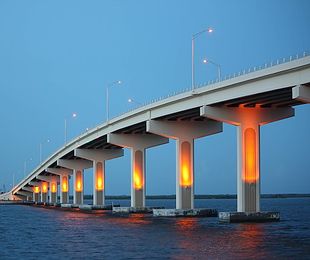
A. Max Brewer Bridge is a $44.8 million high span bridge located within the City of Titusville, just east of US 1 along SR 406. This massive project involved the replacement of an existing low-level steel swing-span bridge (Bridge No. 704049) and south relief bridge (Bridge No. 704125), both constructed in the 1940s. The original bridge was in poor mechanical condition and prone to breakdowns during normal operation, frequently delaying commuters and tourists during peak traffic times. The breakdowns also prohibited large vessels from continuing along the Intracoastal Waterway. The maturing structure was beginning to deteriorate over time, giving FDOT District Five an urgent challenge to be resolved.[1]
Max Brewer Bridge is closed to vehicle traffic during Kennedy Space Center launches and becomes an ideal viewing spot for pedestrians. The bridge is a popular recreational spot for Titusville residents. The bridge grounds offer boat ramps, fishing piers, catwalks, and picnic areas on the water. A brisk walk over the bridge and back is a favorite exercise routine for local walkers.
Florida Fish and Wildlife Conservation Commission (FWC) maintains a field office, and Florida Marine Patrol docks patrol boats, at the northeast corner of the bridge.
 | ||||
| Waterway: North Indian River | Road: SR406 | |||
| City: Titusville | County: Brevard | |||
| Type: Segmental Span | Builder:DRMP | |||
| DOT: 700227 | L: 3207' | H: 65' | Built: 2010-01-01 | |
Location: (28.61758,-80.80274)
Tap for active map.
| ||||
| Completed in 2010, the 3,207' long, 65' high A. Max Brewer Bridge connects the City of Titusville to Merritt Island providing access to the Kennedy Space Center via SR406. Includes a fishing pier and boat ramps on the west side and a 20' observation deck at the crest. This bridge is a good observation site for Kennedy Space Center, when it is closed to vehicle traffic. | ||||
Fact Sheet

Overview: 2010 Segmental span bridge over Indian River on SR406
- Location: A. Max Brewer Memorial Pkwy, Titusville, Brevard, FL 32796
- Roadway: SR406
- Also called: A. Max Brewer Causeway
- Owner: Florida Department of Transportation (FDOT)
- History: Original 1940 low swing span bridge replaced with a 65' high segmental span bridge in 2010
- Builder: DRMP, Inc.
- Cost:$ 44.5 million
- Type: Segmental Span
- Dimensions:
- * Total length: 3,207.0 ft. (0.6 mi.)
- * Deck width: 50.0 ft.
- * Elevation: 65 ft. above sea level
- Location:
- * Approximate latitude, longitude: +28.62036, -80.79814 (decimal degrees) 28°37'13" N, 80°47'53" W (degrees°minutes'seconds")
- * Approximate UTM coordinates: 17/519732/3165942 (zone/easting/northing)
- * Quadrangle map: Titusville