Category:Banana River Water Body: Difference between revisions
mNo edit summary |
mNo edit summary |
||
| (24 intermediate revisions by the same user not shown) | |||
| Line 1: | Line 1: | ||
<div class="irlbody"> | <div class="irlbody irlbow"> | ||
{{IRL header | {{IRL header estuary|cat=Water Body|toc=no}} | ||
<div class="irlcontenttop"> | |||
<div class=" | [[File:Merritt_Island_Dragons_Point.jpg|320px|thumb|right|alt=Banana River at Dragon's Point, Merritt Island|Banana River at Dragon's Point]] | ||
<section begin=about /> | |||
[[File: | Banana River is the smallest of four brackish water lagoons in the [[Indian River Lagoon Estuary|Indian River Lagoon National Estuary]]. The 31-mile-long, 30,000 acre bar-built lagoon is bounded by Kennedy Space Center to the north, Merritt Island to the west, a barrier island to the east and Indian River to the south. | ||
Banana River north of SR528 is well preserved as it lies on federal property where public access is not allowed. Northern Banana River is an important spring habitat (300-500 individuals/survey day) for the West Indian manatee and resident manatees live in the lagoon year-round. Banana River also supports the largest pelican rookery on the Atlantic Coast. | |||
South Banana River is in a densely urbanized area that has heavily impacted the lagoon's [[Banana River Water Quality|water quality]]. | |||
[[ | <section end=about /> | ||
</div> | </div> | ||
<div class=" | <div class="irlcontentmiddle"> | ||
==Banana River Water Body== | |||
[[File:Ares I-X Return to KSC 1.jpg|320px|thumb|right|Ares I-X Return to KSC 1]] | [[File:Ares I-X Return to KSC 1.jpg|320px|thumb|right|alt=Ares I-X Ship Returns to Kennedy Space Center|Ares I-X Return to KSC 1]] | ||
<div class="mw-collapsible" style="width: | Banana Creek connects Banana River to the Indian River south of Max Brewer Bridge (SR404) in Titusville, Florida. Banana River lagoon ranges through Kennedy Space Center and Cape Canaveral Space Force Station property to the Beachline (SR528) causeway. | ||
<div class="irlcollapsetitle">Banana River | |||
In Port Canaveral, the lagoon connects to the Atlantic Ocean via [[Canaveral Lock]]s and to the Indian River via the [[Canaveral Barge Canal]]. Sykes Creek connects to the Banana River south of SR520 in Cocoa Beach. | |||
Banana River lagoon ends at Dragon's Point, the southern tip of Merritt Island, where it joins the [[Indian River]] lagoon at Indian Harbour Beach. | |||
<div class="mw-collapsible mw-collapsed" style="width:330px; overflow:auto;"> | |||
<div class="irlcollapsetitle">Banana River Tributary List</div> | |||
<div class="mw-collapsible-content"> | <div class="mw-collapsible-content"> | ||
<div class="irlcollapsetext">Tributaries are listed from North to South.</div> | <div class="irlcollapsetext">Tributaries are listed from North to South.</div> | ||
| Line 26: | Line 28: | ||
</div></div> | </div></div> | ||
</div> | </div> | ||
<div class=" | <div class="irlcontentmiddle"> | ||
==Banana River Map== | |||
{{#cargo_query: | |||
tables=Waterbody | |||
|fields= Name, CONCAT('[[File:',Image,'|300x180px|frameless|center|alt=',Name,']]')=Image, Type, Water=Basin, County, Description, Article, Coordinates | |||
|where= Water LIKE 'Banana River' | |||
|format=googlemaps | |||
|width=inherit | |||
|height=480px | |||
}} | |||
</div> | |||
<div class="irlcontentmiddle"> | |||
<div class="wikitable"><div class="irltabletitle" style="text-align:left"><h3>Banana River Tributaries</h3></div> | |||
<p>This "Info" table links to infobox pages that display limited data about the subject. Some "Info" pages also contain additional text, images, or videos when available.</p> | |||
<div class="irltabletext" style="text-align:left;margin-bottom:20px"> | |||
* Click '+' to show the description. | |||
* 'Toggle' in additional columns | |||
* Click a column header to resort | |||
* Search by Name, County, Basin, Type | |||
</div> | |||
<div style="margin-top:20px">{{#cargo_query: | |||
tables=Waterbody | |||
|fields=CONCAT( Name,' [[', _pageName,'|(info)]]')=Name, Article, Type, Water=Basin, County, Coordinates, Description | |||
|where=Water LIKE 'Banana River' | |||
|order by=Coordinates DESC | |||
|rows per page=20 | |||
|format=dynamic table | |||
|hidden fields=Article, Type, Basin, County, Coordinates | |||
|details fields=Description | |||
}} | |||
</div> | |||
</div> | |||
<div class="irlcontentmiddle"> | |||
===Banana River Aquatic Preserve=== | |||
[[File:Banana River 001.jpg|320px|thumb|right|alt=Banana River at Merritt Island in Brevard County, Florida|Banana River, Merritt Island, Brevard County]] | |||
The Banana River Aquatic Preserve begins at State Road 528 (Bennett Causeway), extends almost to the southern tip of Merritt Island, and includes Newfound Harbor and Sykes Creek as far north as Hall Road. The incorporated cities bordering the aquatic preserve are Cape Canaveral, Cocoa Beach, Satellite Beach and Indian Harbor Beach, north to south respectively. In addition, Patrick Space Force Base lies along the east shore between Cocoa Beach and Satellite Beach. The Banana River Aquatic Preserve is accessible from the east by U.S. Highway A1A and from the west by State Road 3. | |||
===Brevard County Conservation Areas=== | |||
Brevard's [[Unit:Brevard County Environmentally Endangered Lands Program|Environmentally Endangered Lands (EEL) Program]] preserves 600 acres in Sykes Creek as the [[Unit:Ulumay Sanctuary|Ulumay Sanctuary]] and 330 acres in Cocoa Beach as the [[Unit:Thousand Islands Conservation Area|Thousand Islands Conservation Area]]. | |||
===Banana River No Motor Zone=== | |||
Most of the Banana River north of Port Canaveral and the Beach Line Highway (SR 528) has been closed to motor boats for the protection for manatees since 1990. This area has one of the highest concentrations of manatees in Florida. Boaters generally refer to this area as the “No Motor Zone” as motorized vessels including any vessel having an attached or non-attached internal combustion or electric trolling motor capable of use are prohibited. The boundary of the No Motor Zone is delineated with signs. | |||
This 10,600 acre open water area is one of the few places in Florida free from motor boats and has become a popular destination for paddlers and fishermen. The shoreline on the north, east, and west side of the lagoon is within the “Security Area” of the Kennedy Space Center and Cape Canaveral Space Force Station, therefore access to the No Motor Zone is very limited. | |||
</div> | |||
<div class="irlcontentbottom"> | |||
==See Also== | |||
* [[Banana River]] | |||
* [[Unit:Banana River Aquatic Preserve]] | |||
* [[:Category:Banana River Bridges|Banana River Bridges]] | |||
* [[Canaveral Barge Canal]] | |||
* [[Canaveral Lock]] | |||
* [[Unit:Thousand Islands Conservation Area]] | |||
* [[Unit:Ulumay Sanctuary]] | |||
==Web Links== | ==Web Links== | ||
* [https://floridadep.gov/rcp/aquatic-preserve/locations/banana-river-aquatic-preserve Banana River Aquatic Preserve] | * [https://floridadep.gov/rcp/aquatic-preserve/locations/banana-river-aquatic-preserve Banana River Aquatic Preserve] | ||
* [https://www.arcgis.com/apps/MapSeries/index.html?appid=3113f204a7814a228f0b052262562d01 Banana River BMAP Story Map] | |||
* [https://www.fws.gov/refuge/Merritt_Island/Fishing.html.aspx Merritt Island NWR Fishing] | |||
==Documents== | |||
* [https://floridadep.gov/sites/default/files/banana-river-lagoon-bmap.pdf DEP - Banana River Lagoon Basin Management Action Plan 2013 (PDF)] | |||
{{IRL_notice_water_body}} | |||
</div> | </div> | ||
</div> | </div> | ||
[[Category:Banana River]] | [[Category:Banana River]] | ||
Latest revision as of 06:30, November 23, 2021
Banana River is the smallest of four brackish water lagoons in the Indian River Lagoon National Estuary. The 31-mile-long, 30,000 acre bar-built lagoon is bounded by Kennedy Space Center to the north, Merritt Island to the west, a barrier island to the east and Indian River to the south.
Banana River north of SR528 is well preserved as it lies on federal property where public access is not allowed. Northern Banana River is an important spring habitat (300-500 individuals/survey day) for the West Indian manatee and resident manatees live in the lagoon year-round. Banana River also supports the largest pelican rookery on the Atlantic Coast.
South Banana River is in a densely urbanized area that has heavily impacted the lagoon's water quality.
Banana River Water Body
Banana Creek connects Banana River to the Indian River south of Max Brewer Bridge (SR404) in Titusville, Florida. Banana River lagoon ranges through Kennedy Space Center and Cape Canaveral Space Force Station property to the Beachline (SR528) causeway.
In Port Canaveral, the lagoon connects to the Atlantic Ocean via Canaveral Locks and to the Indian River via the Canaveral Barge Canal. Sykes Creek connects to the Banana River south of SR520 in Cocoa Beach.
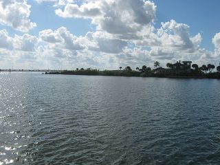
Banana River lagoon ends at Dragon's Point, the southern tip of Merritt Island, where it joins the Indian River lagoon at Indian Harbour Beach.
Brevard
- Banana Creek
- Canaveral Lock
- Canaveral Barge Canal
- Sykes Creek
- Grand Canal
- Indian River
Banana River Map
Banana River Tributaries
This "Info" table links to infobox pages that display limited data about the subject. Some "Info" pages also contain additional text, images, or videos when available.
- Click '+' to show the description.
- 'Toggle' in additional columns
- Click a column header to resort
- Search by Name, County, Basin, Type
| Name | Article | Type | Basin | County | Coordinates | |
|---|---|---|---|---|---|---|
| Name | Article | Type | Basin | County | Coordinates | |
| Banana Creek (info) | Creek | Banana River | Brevard | 28.60073,-80.66184 | ||
| Banana River (info) | Banana River | Lagoon | Banana River | Brevard | 28.44858,-80.62544 | |
| Canaveral Barge Canal East (info) | Canaveral Barge Canal | Canal | Banana River | Brevard | 28.40942,-80.68977 | |
| Canaveral Lock (info) | Canaveral Lock | Canal | Banana River | Brevard | 28.40926,-80.64058 | |
| Sykes Creek (info) | Creek | Banana River | Brevard | 28.38496,-80.68945 | ||
| Grand Canal (info) | Canal | Banana River | Brevard | 28.17998,-80.61007 |
Banana River Aquatic Preserve
The Banana River Aquatic Preserve begins at State Road 528 (Bennett Causeway), extends almost to the southern tip of Merritt Island, and includes Newfound Harbor and Sykes Creek as far north as Hall Road. The incorporated cities bordering the aquatic preserve are Cape Canaveral, Cocoa Beach, Satellite Beach and Indian Harbor Beach, north to south respectively. In addition, Patrick Space Force Base lies along the east shore between Cocoa Beach and Satellite Beach. The Banana River Aquatic Preserve is accessible from the east by U.S. Highway A1A and from the west by State Road 3.
Brevard County Conservation Areas
Brevard's Environmentally Endangered Lands (EEL) Program preserves 600 acres in Sykes Creek as the Ulumay Sanctuary and 330 acres in Cocoa Beach as the Thousand Islands Conservation Area.
Banana River No Motor Zone
Most of the Banana River north of Port Canaveral and the Beach Line Highway (SR 528) has been closed to motor boats for the protection for manatees since 1990. This area has one of the highest concentrations of manatees in Florida. Boaters generally refer to this area as the “No Motor Zone” as motorized vessels including any vessel having an attached or non-attached internal combustion or electric trolling motor capable of use are prohibited. The boundary of the No Motor Zone is delineated with signs.
This 10,600 acre open water area is one of the few places in Florida free from motor boats and has become a popular destination for paddlers and fishermen. The shoreline on the north, east, and west side of the lagoon is within the “Security Area” of the Kennedy Space Center and Cape Canaveral Space Force Station, therefore access to the No Motor Zone is very limited.
See Also
- Banana River
- Unit:Banana River Aquatic Preserve
- Banana River Bridges
- Canaveral Barge Canal
- Canaveral Lock
- Unit:Thousand Islands Conservation Area
- Unit:Ulumay Sanctuary
Web Links
Documents
Site Note:
*Normally a river's course is described in the direction of it's current flow. The Indian River Estuary doesn't have a directional flow, so this website will always describe it's Water Bodies in a north to south direction.
*Lagoons do not have a directional current and some water bodies (tidal marshes, canals and inlets) flow in both directions, so these water bodies are not technically tributaries. However, for this website's purposes, all connecting water bodies regardless of current, may be referred to as tributaries.
Pages in category "Banana River Water Body"
The following 2 pages are in this category, out of 2 total.


