Canaveral Lock: Difference between revisions
mNo edit summary |
mNo edit summary |
||
| (11 intermediate revisions by the same user not shown) | |||
| Line 1: | Line 1: | ||
{{ | <div class="irlbody irlbow"> | ||
[[File:Canaveral lock.jpg| | {{IRL header estuary|cat=Water Body}} | ||
<div class="irlcontenttop"> | |||
[[File:Canaveral lock.jpg|380px|thumb|right|alt=Canaveral Harbor Locks|Canaveral Lock]] | |||
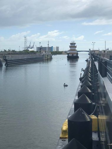
Located between Port Canaveral's West turning basin and the Banana River, Canaveral Lock was constructed by the US Army Corps of Engineers in 1965 to secure safe passage of vessels from the [[Banana River]] to Port Canaveral and the Atlantic Ocean. | |||
The lock reduces tidal-current velocities in Canaveral Harbor, prevents entry of hurricane tides into the Banana River and prevents salt water intrusion. | |||
Canaveral Lock, the largest navigation lock in Florida, was built larger than originally planned to allow passage of the Saturn rocket's first stage, used to put Apollo rockets into space.<ref>https://www.saj.usace.army.mil/CanaveralLock/</ref> | |||
The Canaveral Lock was closed for preventative maintenance in December of 2019 and reopened for navigation on April 3rd of 2020. The maintenance closure was necessary to repair aging and damaged infrastructure in addition to improving public and vessel safety. | |||
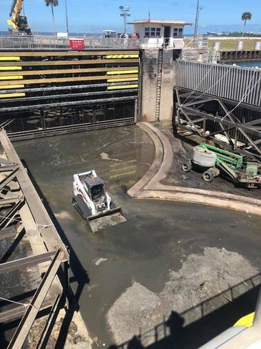
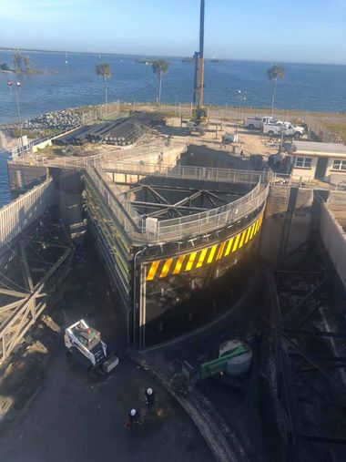
During the maintenance closure, the first in 10 years, the lock's chamber was drained, allowing crews to perform inspections, replace corroded steel structure, paint, install new gate seals and repair manatee protection system components. | |||
</div> | |||
<div class="irlcontentmiddle"> | |||
==Location== | |||
Port Canaveral is located 145 miles south of Jacksonville and 70 miles north of Fort Pierce. The Canaveral Lock is on the west end of the port. | |||
Coordinates: 28°24'33.3"N, 80°38'26.1"W GIS:28.409256,-80.640582 | |||
{{Map Embed|coord=28.409256,-80.640582|zoom=10}} | |||
</div> | |||
<div class="irlcontentmiddle"> | |||
==Canaveral Lock Facts== | ==Canaveral Lock Facts== | ||
[[File:Canaveral lock construction.jpg|380px|thumb|right|alt=Port Canaveral Lock drained for maintenance|Canaveral Lock drained for maintenance]] | |||
Canaveral Harbor history: Created in 1951 by an artificial cut through the barrier beach to provide access to a turning basin in the Banana River, jetties completed in 1954 | Canaveral Harbor history: Created in 1951 by an artificial cut through the barrier beach to provide access to a turning basin in the Banana River, jetties completed in 1954 | ||
| Line 21: | Line 38: | ||
Lock cost: $5.6 million total (includes bridges, roads, barge canal enlargement), cost of lock $2.96 million | Lock cost: $5.6 million total (includes bridges, roads, barge canal enlargement), cost of lock $2.96 million | ||
<div class="irlcontentmiddle"> | |||
==Canaveral Lock Technical Details== | ==Canaveral Lock Technical Details== | ||
[[File:Canaveral lock construction 02.jpg|380px|thumb|right|alt=Canaveral Lock Gate under repair|Canaveral Lock Gate under maintenance]] | |||
Gate type: Sector gate (pie-slice shape), similar to gates on the Okeechobee Waterway Gate size: 23 feet high, 54 feet wide, 54 feet across the end | Gate type: Sector gate (pie-slice shape), similar to gates on the Okeechobee Waterway Gate size: 23 feet high, 54 feet wide, 54 feet across the end | ||
| Line 36: | Line 54: | ||
Concrete slab thickness at bottom of gate: 10 feet, widest point between gates is 184 feet | Concrete slab thickness at bottom of gate: 10 feet, widest point between gates is 184 feet | ||
</div> | |||
<div class="irlvideo"> | |||
==Canaveral Lock Video== | |||
{{#evu:https://www.youtube.com/watch?v=SiQxBJKf9Sc|width=inherit|alignment=center}} | |||
</div> | |||
<div class="irlvideo" style="margin-top:20px"> | |||
{{#evu:https://www.youtube.com/watch?v=2icSFoihhxo|width=inherit|alignment=center}} | |||
</div> | |||
<div class="irlcontentbottom"> | |||
==Related Articles== | |||
* [[Canaveral Locks Bridge]] | |||
* [[Canaveral Barge Canal]] | |||
==Web Links== | ==Web Links== | ||
| Line 41: | Line 74: | ||
==References== | ==References== | ||
<references /> | |||
</div> | |||
{{IRL footer estuary|cat=Water Body}} | |||
</div> | |||
[[Category:Banana River Water Body]] | [[Category:Banana River Water Body]] | ||
Latest revision as of 19:07, November 22, 2021
Located between Port Canaveral's West turning basin and the Banana River, Canaveral Lock was constructed by the US Army Corps of Engineers in 1965 to secure safe passage of vessels from the Banana River to Port Canaveral and the Atlantic Ocean.
The lock reduces tidal-current velocities in Canaveral Harbor, prevents entry of hurricane tides into the Banana River and prevents salt water intrusion.
Canaveral Lock, the largest navigation lock in Florida, was built larger than originally planned to allow passage of the Saturn rocket's first stage, used to put Apollo rockets into space.[1]
The Canaveral Lock was closed for preventative maintenance in December of 2019 and reopened for navigation on April 3rd of 2020. The maintenance closure was necessary to repair aging and damaged infrastructure in addition to improving public and vessel safety.
During the maintenance closure, the first in 10 years, the lock's chamber was drained, allowing crews to perform inspections, replace corroded steel structure, paint, install new gate seals and repair manatee protection system components.
Location
Port Canaveral is located 145 miles south of Jacksonville and 70 miles north of Fort Pierce. The Canaveral Lock is on the west end of the port.
Coordinates: 28°24'33.3"N, 80°38'26.1"W GIS:28.409256,-80.640582
Canaveral Harbor history: Created in 1951 by an artificial cut through the barrier beach to provide access to a turning basin in the Banana River, jetties completed in 1954
Lift of lock: Varies by tide stage in Canaveral Harbor and water level in the Banana River. Normal maximum difference in water levels is 3 to 4 feet.
How water level is changed: By releasing water from the ocean side to the Banana River side or vice versa
Lock staff: Five Corps of Engineers personnel
Major commodities through lock: Petroleum, NASA Shuttle booster rockets, commercial fishing vessels
Lock usage: Any vessel with draft up to 12 feet, no charge for lockage. Lockage takes 20 to 30 minutes.
Lock cost: $5.6 million total (includes bridges, roads, barge canal enlargement), cost of lock $2.96 million
Gate type: Sector gate (pie-slice shape), similar to gates on the Okeechobee Waterway Gate size: 23 feet high, 54 feet wide, 54 feet across the end
Gate weight: 47 tons (similar to the weight of 40 cars)
Lock chamber type: Earth walls, stone bottom, stone riprap on walls
Water seal type: Rubber cushion
Gate skin plate thickness: 3/8 inch
Concrete in gate monoliths: 15,000 cubic yards
Concrete slab thickness at bottom of gate: 10 feet, widest point between gates is 184 feet


