Indian River: Difference between revisions
mNo edit summary |
|||
| Line 17: | Line 17: | ||
<br/> | <br/> | ||
'''GIS:''' 28.079483, -80.588031</p> | '''GIS:''' 28.079483, -80.588031</p> | ||
The northern | The northern end of the Indian River lies in [[:Category:Brevard County|Brevard County's]] Scottsmoor, the lagoon merges with the [[Banana River]] lagoon at the southern tip of Merritt Island, extends southward to [[:Category:Palm Beach County|Palm Beach County's]] Loxahatchee River , where it meets it's southern boundary at Jupiter Inlet. | ||
</div> | </div> | ||
</div> | </div> | ||
<div class="irlcontentmiddle"> | <div class="irlcontentmiddle"> | ||
<div style="width:100%;float:left"> | <div style="width:100%;float:left"> | ||
==Water Body== | ==Water Body== | ||
{{IRL Indian River Tributaries}} | {{IRL Indian River Tributaries}} | ||
Revision as of 14:25, December 13, 2019
The Indian River is the largest of 3 major lagoons in the Indian River Lagoon National Estuary Program
About the Indian River
The Indian River is a 121 mile long brackish water lagoon spanning 5 counties on Florida's East Coast. It is the largest of 3 water bodies in the Indian River Lagoon National Estuary watershed.
.jpg)
Location
Coordinates: 28°04'46.1"N 80°35'16.9"W
GIS: 28.079483, -80.588031
The northern end of the Indian River lies in Brevard County's Scottsmoor, the lagoon merges with the Banana River lagoon at the southern tip of Merritt Island, extends southward to Palm Beach County's Loxahatchee River , where it meets it's southern boundary at Jupiter Inlet.
Water Body
Causeways and Bridges
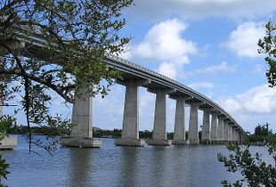 | ||||
| Waterway: Central Indian River | Road: SR510 | |||
| City: Wabasso | County: Indian River | |||
| Type: Concrete High Span | Builder:Scott Construction | |||
| DOT: 880051, 880053 | L: 1689' | H: 62' | Built: 1970-01-01 | |
Location: (27.75975,-80.41797)
Tap for active map.
| ||||
| Wabasso Bridge is a two-lane concrete bridge spanning SR510 over the Indian River and Intracoastal Waterway in Indian River County, Florida. Article | ||||
Odor
During the hot summer months the earthen berm causeways tend to impede the flow of algae and rotting seagrass which results in an odor of hydrogen sulfide in some areas along the river.