Page values for "Info:Mathers Bridge"
From Indian River Lagoon Project
"bridge" values
1 row is stored for this page| Name | Mathers Bridge |
| Road | SR3 |
| Water | Banana River |
| City | Indian Harbour Beach |
| County | Brevard |
| Type | Metal Swing Span |
| Builder | Austin Bridge Co. |
| Length | 792 |
| Built | 2005 |
| FDOT | 704063 |
| Coordinates | 28.1492,-80.6061 |
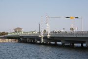
| Description | Mathers Bridge is a 700-foot-long (210 m) low-level swing bridge located on the southern tip of Merritt Island, Florida, crossing the Banana River at the south end of State Road 3. The bridge was built in 1927 by John Mathers in order to connect Merritt Island to what is now Indian Harbour Beach, and was moved to its present location in 1952. It was constructed by the Austin Brothers Bridge Company. The bridge and the control house were rehabilitated in 2007. |
| Article | Mathers Bridge Historic Engineering Record |
| Image | |
| Link1 | https://www.google.com/maps/@?api=1&map_action=pano&viewpoint=28.149365%2C-80.605634&heading=246.15&pitch=12.20&fov=90&pano=U6fLd25sLTdt6rSnyOQPfg Street View Walkaround |
| Link2 | http://lcweb2.loc.gov/master/pnp/habshaer/fl/fl0500/fl0555/data/fl0555data.pdf NPS Historic Engineering Record |
| Poster | Admin |
| Posted | 20191202155425 |
