Banana River: Difference between revisions
mNo edit summary |
mNo edit summary |
||
| Line 8: | Line 8: | ||
==About== | ==About== | ||
The '''Banana River''' is a 31 mile long lagoon that lies between Cape Canaveral and Merritt Island in [[:Category:Brevard County|Brevard County, Florida]]. The southern end of the Banana River lagoon connects to the [[Indian River]] and is part of the [[Indian River Lagoon Estuary]]. The Banana River has an outlet to the Atlantic Ocean via a lock into Port Canaveral. Providing habitats for many marine species, the waist deep brackish water lagoon includes salt marshes, mangrove swamps, seagrass beds, drift algae, oyster bars, mud flats, and spoil islands. Commercial and recreational activities in the lagoon generate more than US$ 800 million annually for the local economy. | The '''Banana River''' is a 31 mile long lagoon that lies between Cape Canaveral and Merritt Island in [[:Category:Brevard County|Brevard County, Florida]]. The southern end of the Banana River lagoon connects to the [[Indian River]] and is part of the [[Indian River Lagoon Estuary]]. The Banana River has an outlet to the Atlantic Ocean via a lock into Port Canaveral. Providing habitats for many marine species, the waist deep brackish water lagoon includes salt marshes, mangrove swamps, seagrass beds, drift algae, oyster bars, mud flats, and spoil islands. Commercial and recreational activities in the lagoon generate more than US$ 800 million annually for the local economy. | ||
Banana River Aquatic Preserve is located in north central Brevard County, separating Merritt Island on the west and the beach barrier island on the east. The surface water area of the aquatic preserve is approximately 30,000 acres.<ref name="fwsfish /> The aquatic preserve begins at State Road 528 (Bennett Causeway), extends almost to the southern tip of Merritt Island, and includes Newfound Harbor and Sykes Creek as far north as Hall Road. The incorporated cities bordering the aquatic preserve are Cape Canaveral, Cocoa Beach, Satellite Beach and Indian Harbor Beach, north to south respectively. In addition, Patrick Air Force Base lies along the Banana River Lagoon between Cocoa Beach and Satellite Beach. The aquatic preserve is accessible from the east by U.S. Highway A1A and from the west by State Road 3. Numerous parks and boat ramps provide direct public access to the aquatic preserve. | |||
The northern Banana River has been the most important spring habitat (300-500 individuals/survey day)<ref name=fdepbr /> for the east coast population of manatees, and large numbers of manatees use the Banana River almost year-round. In addition, the Banana River supports the largest pelican rookery on the Atlantic Coast, a significant population of alligators, and diamondback terrapin turtles. | |||
==History== | ==History== | ||
Historically, the Banana River was a continuous waterway that completely separated Merritt Island from Cape Canaveral | Historically, the Banana River was a continuous waterway that completely separated Merritt Island from Cape Canaveral. In 1964, the Crawlerway was built at Kennedy Space Center, connecting Merritt Island to Cape Canaveral and dividing the Banana River into northern and southern lagoons. | ||
===Banana River Air Station=== | |||
Construction of the Banana River Naval Air Station began in December 1939 and the station was commissioned on 1 October 1940. The station supported seaplane patrol operations during World War II, a blimp squadron which conducted search and rescue along Florida's east coast, a PBM seaplane pilot training program, and an advanced navigation school. In 1944 the station consisted of 391 officers, 2492 enlisted and 587 civilians. The number of aircraft present on the base, including F6 Hellcats and O52U Kingfishers, reached a high of 228. The station continued to operate as a Navy support base for two years after the war, but the installation was finally deactivated on 1 August 1947.<ref name=brnas /> | |||
The Navy transferred the station to the Air Force on 1 September 1948 and it was renamed the Joint Long Range Proving Ground (JLRPG). On 1 August 1950, it was renamed Patrick Air Force Base in honor of Major General Mason Patrick. Patrick Air Force Base is now the headquarters of the 45th Space Wing, the parent organization responsible for operations at Cape Canaveral Air Force Station.<ref name=brnas /> | |||
<div style="width:100%;float:left"><!-- Water Body --> | <div style="width:100%;float:left"><!-- Water Body --> | ||
===Water Body=== | ===Water Body=== | ||
| Line 20: | Line 29: | ||
==Images== | ==Images== | ||
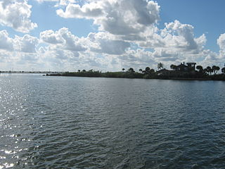
[[File:Merritt Island, Florida (southern tip).jpg|320px|thumb|right|Banana River Southern Terminus at Dragon's Point, Merritt Island, Florida| link= ]] | [[File:Merritt Island, Florida (southern tip).jpg|320px|thumb|right|Banana River Southern Terminus at Dragon's Point, Merritt Island, Florida| link= ]] | ||
[[File:Tugboats pull Pegasus barge through Banana River.jpg|320px|thumb|right|Tugboats pull Pegasus barge through Banana River]] | |||
[[File:Ares I-X Return to KSC 1.jpg|320px|thumb|right|Ares I-X Return to KSC 1]] | |||
[[File:Banana River Night Launch 320.jpg|320px|thumb|right|KSC Night Launch Over Banana River]] | |||
</div><!-- END Content Top RIGHT div --> | </div><!-- END Content Top RIGHT div --> | ||
</div><!-- End Content Top div --> | </div><!-- End Content Top div --> | ||
<div style="width:100%;float:left"><!-- Content Middle div --> | <div style="width:100%;float:left"><!-- Content Middle div --> | ||
<div style="width:100%;float:left"><!-- Content Mid 1 div --> | <div style="width:100%;float:left"><!-- Content Mid 1 div --> | ||
<div style="width:100%;float:right"><!-- Video div --> | |||
==Video== | |||
<!-- EmbedVideo example{{#ev:service|id|dimensions|alignment|description|container|urlargs|autoresize|valignment}} --> | |||
{{#ev:youtube|A37f1pMeiAA|640px|center||||autoresize}} | |||
</div><!-- end video div --> | |||
</div><!-- END Content Mid 1 div --> | </div><!-- END Content Mid 1 div --> | ||
<div style="width:100%;float:left"><!-- Content Mid 2 Div --> | <div style="width:100%;float:left"><!-- Content Mid 2 Div --> | ||
| Line 31: | Line 48: | ||
<div style="width:100%;float:left"><!-- Web Links Div --> | <div style="width:100%;float:left"><!-- Web Links Div --> | ||
==Web Links== | ==Web Links== | ||
*[https:// | * [https://www.waterqualitydata.us/provider/STORET/21FLCEN_WQX/21FLCEN_WQX-27010602/ Banana River Water Quality Map] | ||
</div><!-- End Web Links Div --> | </div><!-- End Web Links Div --> | ||
<div style="width:100%;float:left"><!-- References div --> | <div style="width:100%;float:left"><!-- References div --> | ||
==References== | ==References== | ||
<references /> | <references> | ||
<ref name=fwsfish>[https://www.fws.gov/refuge/Merritt_Island/Fishing.html.aspx FWS Merritt Island Refuge Fishing]</ref> | |||
<ref name=fdepbr>[https://floridadep.gov/rcp/aquatic-preserve/locations/banana-river-aquatic-preserve About the Banana River Aquatic Preserve]</ref> | |||
<ref name=brnas>[http://afspacemuseum.org/displays/BRNAS/ Air Force & Space Museum Banana River Naval Air Station]</ref> | |||
</references> | |||
<br><br> | <br><br> | ||
</div><!-- END References div --> | </div><!-- END References div --> | ||
Revision as of 00:26, October 30, 2019
The Banana River is one of 3 brackish lagoons in the Indian River Lagoon National Estuary Program
About
The Banana River is a 31 mile long lagoon that lies between Cape Canaveral and Merritt Island in Brevard County, Florida. The southern end of the Banana River lagoon connects to the Indian River and is part of the Indian River Lagoon Estuary. The Banana River has an outlet to the Atlantic Ocean via a lock into Port Canaveral. Providing habitats for many marine species, the waist deep brackish water lagoon includes salt marshes, mangrove swamps, seagrass beds, drift algae, oyster bars, mud flats, and spoil islands. Commercial and recreational activities in the lagoon generate more than US$ 800 million annually for the local economy.
Banana River Aquatic Preserve is located in north central Brevard County, separating Merritt Island on the west and the beach barrier island on the east. The surface water area of the aquatic preserve is approximately 30,000 acres.[1] The aquatic preserve begins at State Road 528 (Bennett Causeway), extends almost to the southern tip of Merritt Island, and includes Newfound Harbor and Sykes Creek as far north as Hall Road. The incorporated cities bordering the aquatic preserve are Cape Canaveral, Cocoa Beach, Satellite Beach and Indian Harbor Beach, north to south respectively. In addition, Patrick Air Force Base lies along the Banana River Lagoon between Cocoa Beach and Satellite Beach. The aquatic preserve is accessible from the east by U.S. Highway A1A and from the west by State Road 3. Numerous parks and boat ramps provide direct public access to the aquatic preserve.
The northern Banana River has been the most important spring habitat (300-500 individuals/survey day)[2] for the east coast population of manatees, and large numbers of manatees use the Banana River almost year-round. In addition, the Banana River supports the largest pelican rookery on the Atlantic Coast, a significant population of alligators, and diamondback terrapin turtles.
History
Historically, the Banana River was a continuous waterway that completely separated Merritt Island from Cape Canaveral. In 1964, the Crawlerway was built at Kennedy Space Center, connecting Merritt Island to Cape Canaveral and dividing the Banana River into northern and southern lagoons.
Banana River Air Station
Construction of the Banana River Naval Air Station began in December 1939 and the station was commissioned on 1 October 1940. The station supported seaplane patrol operations during World War II, a blimp squadron which conducted search and rescue along Florida's east coast, a PBM seaplane pilot training program, and an advanced navigation school. In 1944 the station consisted of 391 officers, 2492 enlisted and 587 civilians. The number of aircraft present on the base, including F6 Hellcats and O52U Kingfishers, reached a high of 228. The station continued to operate as a Navy support base for two years after the war, but the installation was finally deactivated on 1 August 1947.[3]
The Navy transferred the station to the Air Force on 1 September 1948 and it was renamed the Joint Long Range Proving Ground (JLRPG). On 1 August 1950, it was renamed Patrick Air Force Base in honor of Major General Mason Patrick. Patrick Air Force Base is now the headquarters of the 45th Space Wing, the parent organization responsible for operations at Cape Canaveral Air Force Station.[3]
Water Body
The smallest of the three National Estuary lagoons, Banana River is bounded by KSC to the north, urbanized North Merritt Island on the west shore, an urbanized barrier island on the east shore and Indian River to the south.


.jpg)