Info:Haulover Canal Bridge: Difference between revisions
From Indian River Lagoon Project
mNo edit summary |
mNo edit summary |
||
| (2 intermediate revisions by the same user not shown) | |||
| Line 3: | Line 3: | ||
|Road=SR3 | |Road=SR3 | ||
|Water=Mosquito Lagoon | |Water=Mosquito Lagoon | ||
|City= | |City=Allenhurst | ||
|County=Brevard | |County=Brevard | ||
|Coordinates=28.73634,-80.75459 | |Coordinates=28.73634,-80.75459 | ||
| Line 14: | Line 14: | ||
|Article=Haulover Canal | |Article=Haulover Canal | ||
|Image=image-haulover-canal-bridge.jpg | |Image=image-haulover-canal-bridge.jpg | ||
|Link1=https:// | |Link1=https://www.google.com/maps/@28.7359177,-80.7542451,3a,60y,321.23h,84.45t/data=!3m6!1e1!3m4!1szAL7n3TgcVGucIHt9yA_gg!2e0!7i16384!8i8192 Street View | ||
|Link2=https://images.nasa.gov/search-results?q=haulover%20canal&page=1&media=image,video,audio&yearStart=1920&yearEnd=2019 NASA Haulover Photo Gallery | |Link2=https://images.nasa.gov/search-results?q=haulover%20canal&page=1&media=image,video,audio&yearStart=1920&yearEnd=2019 NASA Haulover Photo Gallery | ||
|Link3=https:// | |Link3=https://cdn.loc.gov/master/pnp/habshaer/fl/fl0700/fl0786/data/fl0786data.pdf NASA RECORD CANAVERAL AFS 1964 with HAULOVER BRIDGE PHOTOS (PDF 67pp) | ||
|Poster=Admin | |Poster=Admin | ||
|Posted=20191204000204 | |Posted=20191204000204 | ||
}} | }} | ||
{{Bridge_Data_Query|where=Number_008|like=703004 }} | {{Bridge_Data_Query|where=Number_008|like=703004 }} | ||
Latest revision as of 22:41, February 19, 2021
Haulover Canal Bridge | ||||
|---|---|---|---|---|
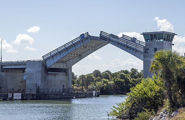
| 1964 U.S. Army Corps of Engineers' Bascule double leaf drawbridge crossing Florida SR3 (N Courtney Parkway) over the Haulover Canal in the Merritt Island Wildlife Refuge. Article | ||||
| Waterway: Mosquito Lagoon | Road: SR3 | |||
| City: Allenhurst | County: Brevard | |||
| Type: Bascule Double Leaf | Builder:McCormick and Sons | |||
| DOT: 703004 | H: 27' | Built: 1964 | ||
Location: 28.73634,-80.75459
| ||||
| Number | 703004 |
| Route | 00000 |
| Place | |
| County | Brevard |
| Features | HAULOVER CANAL |
| Facility | COURTENAY PARKWAY |
| Location | 8.6 MILES SOUTH OF US 1 |
| Latitude | 28441095 |
| Longitude | 80451679 |
| Service On Roadway | Highway |
| Service Under Roadway | Waterway |
| Owner | NASA |
| Built | 1965 |
| Rebuilt | |
| Lanes | 2 |
| Lane Direction | 2 way |
| Direction | |
| Traffic | 675 |
| Traffic Year | 2016 |
| Future Traffic | |
| Future Traffic Year | |
| Length | 68m |
| Width | 10m |
| Clearance | |
| Kind | Steel |
| Type | Movable - Bascule |
| Deck Type | Open Grating |
| Critical | |
| Inspection Date (mm-yy) | 07-17 |
| Deck | Good |
| Superstructure | Fair |
| Substructure | Satisfactory |
| Channel | Bank protection is in need of minor repairs. River control devices and embankment protection have a little minor damage. Banks and/or channel have minor amounts of drift. |
| Culvert | N/A |
| Scour | Bridge foundations determined to be stable for assessed or calculated scour condition. Scour is determined to be within the limits of footing or piles (Example B) by assessment (i.e.,bridge foundations are on rock formations that have been determined to resist scour within the service life of the bridge), by calculations or by installation of properly designed countermeasures |
