Info:Mathers Bridge: Difference between revisions
From Indian River Lagoon Project
Created page with "{{Bridge |Name=Mathers Bridge |Road=SR 3 |Water=Banana River |City=Indian Harbour Beach |County=Brevard |Coordinates=28.14914, -80.60607 |Type=Metal Swing Span |Builder=Austin..." |
|||
| (19 intermediate revisions by the same user not shown) | |||
| Line 1: | Line 1: | ||
{{Bridge | {{Bridge | ||
|Name=Mathers Bridge | |Name=Mathers Bridge | ||
|Road= | |Road=SR3 | ||
|Water=Banana River | |Water=Banana River | ||
|City=Indian Harbour Beach | |City=Indian Harbour Beach | ||
|County=Brevard | |County=Brevard | ||
|Coordinates=28. | |Coordinates=28.1492,-80.6061 | ||
|Type=Metal Swing Span | |Type=Metal Swing Span | ||
|Builder=Austin Bridge Co. | |Builder=Austin Bridge Co. | ||
| Line 14: | Line 14: | ||
The bridge was built in 1927 by John Mathers in order to connect Merritt Island to what is now Indian Harbour Beach, and was moved to its present location in 1952. It was constructed by the Austin Brothers Bridge Company. The bridge and the control house were rehabilitated in 2007. | The bridge was built in 1927 by John Mathers in order to connect Merritt Island to what is now Indian Harbour Beach, and was moved to its present location in 1952. It was constructed by the Austin Brothers Bridge Company. The bridge and the control house were rehabilitated in 2007. | ||
|Link1= | |Article=Mathers Bridge Historic Engineering Record | ||
|Link2=http://lcweb2.loc.gov/master/pnp/habshaer/fl/fl0500/fl0555/data/fl0555data.pdf | |Image=Mathers Bridge 01.jpg | ||
|Link1=https://www.google.com/maps/@?api=1&map_action=pano&viewpoint=28.149365%2C-80.605634&heading=246.15&pitch=12.20&fov=90&pano=U6fLd25sLTdt6rSnyOQPfg Street View Walkaround | |||
|Link2=http://lcweb2.loc.gov/master/pnp/habshaer/fl/fl0500/fl0555/data/fl0555data.pdf NPS Historic Engineering Record | |||
|Poster=Admin | |Poster=Admin | ||
| | |Posted=20191202155425 | ||
}} | }} | ||
==National Bridge Inventory Data== | |||
{{Bridge_Data_Query|where=Number_008|like=704063 }} | |||
==See Also== | |||
* [[Mathers_Bridge_Historic_Engineering_Record]] | |||
* [[History:Mathers_Bridge_Completed_1927-06-16]] | |||
<div class="irlvideo" style="width:100%"> | |||
==Video== | |||
Select a video to play or visit the [https://www.youtube.com/channel/UCHtV0jOmRQMpJEtUXfIjAbA Indian River Lagoon News YouTube Channel] - [https://www.youtube.com/playlist?list=PLCiZ8bCTmnlj4uMUPuTZMwHaYEMqj2BsV Mathers Bridge Video Playlist]. | |||
{{#evl:l9G_d2yHRTQ|Mathers Bridge Part I: The Mathers Experience|1|player=youtube}} | |||
{{#evl:5RgsXPlviUM|Mathers Bridge Part II: The History|2|player=youtube}} | |||
<evlplayer w="340" h="220" id="youtube" style="width:inherit;">https://img.youtube.com/vi/l9G_d2yHRTQ/0.jpg</evlplayer> | |||
</div> | |||
Latest revision as of 07:07, June 3, 2023
Mathers Bridge | ||||
|---|---|---|---|---|
 | ||||
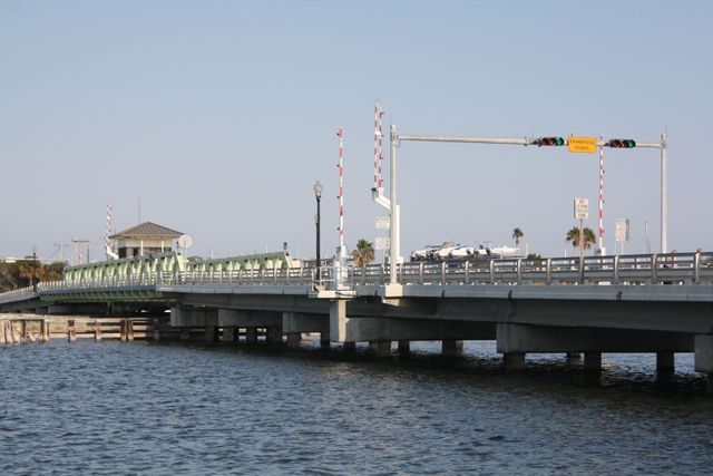
| Mathers Bridge is a 700-foot-long (210 m) low-level swing bridge located on the southern tip of Merritt Island, Florida, crossing the Banana River at the south end of State Road 3.
The bridge was built in 1927 by John Mathers in order to connect Merritt Island to what is now Indian Harbour Beach, and was moved to its present location in 1952. It was constructed by the Austin Brothers Bridge Company. The bridge and the control house were rehabilitated in 2007. Article | ||||
| Waterway: Banana River | Road: SR3 | |||
| City: Indian Harbour Beach | County: Brevard | |||
| Type: Metal Swing Span | Builder:Austin Bridge Co. | |||
| DOT: 704063 | L: 791.7' | Built: 2005 | ||
Location: 28.1492,-80.6061
| ||||
National Bridge Inventory Data
| Number | 704063 |
| Route | 00003 |
| Place | Indian Harbour Beach |
| County | Brevard |
| Features | 'Banana River ' |
| Facility | 'Banana River Drive' |
| Location | '0.3 Mile West of SR-513 ' |
| Latitude | 28085715 |
| Longitude | 80362216 |
| Service On Roadway | Highway - Pedestrian |
| Service Under Roadway | Waterway |
| Owner | County |
| Built | 1927 |
| Rebuilt | 2005 |
| Lanes | 2 |
| Lane Direction | 2 way |
| Direction | |
| Traffic | 2569 |
| Traffic Year | 2016 |
| Future Traffic | 2970 |
| Future Traffic Year | 2036 |
| Length | 242m |
| Width | 7m |
| Clearance | |
| Kind | Steel |
| Type | Movable - Swing |
| Deck Type | Open Grating |
| Critical | |
| Inspection Date (mm-yy) | 03-16 |
| Deck | Good |
| Superstructure | Very Good |
| Substructure | Good |
| Channel | Bank protection is in need of minor repairs. River control devices and embankment protection have a little minor damage. Banks and/or channel have minor amounts of drift. |
| Culvert | N/A |
| Scour | Bridge is scour critical; bridge foundations determined to be unstable for assessed or calculated scour conditions: Scour within limits of footing or piles. Scour below spread-footing base or pile tips. |
See Also
Video
Select a video to play or visit the Indian River Lagoon News YouTube Channel - Mathers Bridge Video Playlist.
Mathers Bridge Part I: The Mathers Experience
Mathers Bridge Part II: The History