Mosquito Lagoon Water Body: Difference between revisions
mNo edit summary |
mNo edit summary |
||
| Line 1: | Line 1: | ||
<div class="irlbody"><!-- Body Content Div --> | |||
<div class="irlheader"><!-- Header Div --> | |||
{{IRL header bow}} | {{IRL header bow}} | ||
==About the | <p class="irlsubtitle">28 mile long Mosquito Lagoon covers 38,000 acres of submerged land.</p> | ||
</div><!-- End Header Div --> | |||
<div | |||
<div class="irlcontenttop"><!-- Content Top div --> | |||
<div class="irlcontentleft"><!-- Content Top LEFT div --> | |||
<div class="irlabout"><!-- About div --> | |||
==About== | |||
The Mosquito Lagoon is bounded on the north by Volusia County's Ponce de Leon Inlet, on the west by Merritt Island National Refuge, on the west by Canaveral National Seashore, and on the South by Kennedy Space Center. The lagoon is the least developed area remaining on Central Florida's East Coast. Two thirds of Mosquito Lagoon is protected by the U.S. Fish and Wildlife Service (FWC) and NASA. The northern end of Mosquito Lagoon is protected under Florida's Department of Environmental Protection (FDEP) Aquatic Preserve program.<ref name=fdepmlap /> | |||
===Merrit Island National Wildlife Refuge=== | |||
The refuge traces its beginnings to the development of the nation’s Space Program. In 1962, NASA acquired 140,000 acres of land, water, and marshes adjacent to Cape Canaveral to establish the John F. Kennedy Space Center. NASA built a launch complex and other space-related facilities, but development of most of the area was not necessary. In1963 the U.S. Fish and Wildlife Service signed an agreement to establish the refuge and in 1975 a second agreement established Canaveral National Seashore. Today, the Department of Interior manages most of the unused portions of the Kennedy Space Center as a National Wildlife Refuge and National Seashore. | |||
===Canaveral National Seashore=== | |||
The Canaveral National Seashore is home to more than 1,000 plant species and 310 bird species. CANA occupies 57,662 acres (23,335 ha)[1] (including lagoons). The park's 24-mile-long beach is the longest undeveloped beach on the east coast of the state. The southern part is also known as Playalinda Beach, the middle section as Klondike Beach, and the northern section as Apollo Beach. | |||
</div><!-- End About div --> | |||
<div class="irlbow"><!-- Water Body div --> | |||
==Mosquito Lagoon Water Bodies== | ==Mosquito Lagoon Water Bodies== | ||
{{IRL_Mosquito_Lagoon_Tributaries}} | {{IRL_Mosquito_Lagoon_Tributaries}} | ||
</div> | </div><!-- End Water Body div --> | ||
<div | </div> <!-- END Content Top LEFT div --> | ||
<div class="irlcontentright"><!-- Content Top RIGHT div --> | |||
==Images== | |||
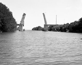
[[Image:haulover canal 001.jpg|320px|thumb|right|Haulover Canal]] | |||
</div><!-- END Content Top RIGHT div --> | |||
</div><!-- End Content Top div --> | |||
<div class="irlcontentbottom"><!-- Content Bottom Div --> | |||
<div class="irlcontentweblinks"><!-- Web Links Div --> | |||
==Web Links== | |||
* [https://floridadep.gov/rcp/aquatic-preserve/locations/mosquito-lagoon-aquatic-preserve FDEP - Mosquito Lagoon Aquatic Preserve] | |||
* [https://www.fws.gov/refuge/Merritt_Island/Fishing.html.aspx FWS - Merritt Island NWR Fishing] | |||
* [http://www.mpatlas.org/mpa/sites/8001/ Atlas of Marine Protection Mosquito Lagoon Aquatic Preserve] | |||
* [https://www.nps.gov/cana/index.htm Canaveral National Seashore] | |||
</div><!-- End Web Links Div --> | |||
<div class="irlcontentref"><!-- References div --> | |||
==References== | |||
<references> | |||
<ref name=fdepmlap>[https://floridadep.gov/rcp/aquatic-preserve/locations/mosquito-lagoon-aquatic-preserve FDEP - Mosquito Lagoon Aquatic Preserve]</ref> | |||
</references> | |||
</div><!-- END References div --> | |||
</div><!-- END Content Bottom Div --> | |||
<div class="irlfooter">{{IRL footer bow}}</div><!-- Footer div --> | |||
</div><!-- END Body Content div --> | |||
[[Category:Mosquito Lagoon]] | [[Category:Mosquito Lagoon]] | ||
[[Category:Water Body]] | [[Category:Water Body]] | ||
Revision as of 15:24, October 30, 2019
28 mile long Mosquito Lagoon covers 38,000 acres of submerged land.
About
The Mosquito Lagoon is bounded on the north by Volusia County's Ponce de Leon Inlet, on the west by Merritt Island National Refuge, on the west by Canaveral National Seashore, and on the South by Kennedy Space Center. The lagoon is the least developed area remaining on Central Florida's East Coast. Two thirds of Mosquito Lagoon is protected by the U.S. Fish and Wildlife Service (FWC) and NASA. The northern end of Mosquito Lagoon is protected under Florida's Department of Environmental Protection (FDEP) Aquatic Preserve program.[1]
Merrit Island National Wildlife Refuge
The refuge traces its beginnings to the development of the nation’s Space Program. In 1962, NASA acquired 140,000 acres of land, water, and marshes adjacent to Cape Canaveral to establish the John F. Kennedy Space Center. NASA built a launch complex and other space-related facilities, but development of most of the area was not necessary. In1963 the U.S. Fish and Wildlife Service signed an agreement to establish the refuge and in 1975 a second agreement established Canaveral National Seashore. Today, the Department of Interior manages most of the unused portions of the Kennedy Space Center as a National Wildlife Refuge and National Seashore.
The Canaveral National Seashore is home to more than 1,000 plant species and 310 bird species. CANA occupies 57,662 acres (23,335 ha)[1] (including lagoons). The park's 24-mile-long beach is the longest undeveloped beach on the east coast of the state. The southern part is also known as Playalinda Beach, the middle section as Klondike Beach, and the northern section as Apollo Beach.
