Category:Water Body: Difference between revisions
From Indian River Lagoon Project
mNo edit summary |
|||
| (38 intermediate revisions by the same user not shown) | |||
| Line 1: | Line 1: | ||
<div class="irlbody"> | <div class="irlbody irlbow"> | ||
{{IRL header | {{IRL header estuary|cat=Water Body|depth=0|toc=no}} | ||
<div class="irlcontenttop"> | <div class="irlcontenttop"> | ||
The 181 mile long '''[[Indian River Lagoon Estuary|Indian River Lagoon National Estuary]]''' ranges through 6 Florida Atlantic Coast counties. | |||
The IRL Estuary includes 4 main water bodies, [[Halifax River]], [[Mosquito Lagoon|Mosquito]], [[Banana River]] and [[Indian River]] lagoons.<ref name="epatreasure" /> | |||
</div> | </div> | ||
<div class="irlcontentmiddle"> | <div class="irlcontentmiddle"> | ||
== | ==Indian River Estuary Map== | ||
{{#cargo_query: | |||
tables=Waterbody | |||
|fields= Name, CONCAT('[[File:',Image,'|300x180px|frameless|center|',Name,'|link=Category:',Name,' Water Body|alt=',Name,']]')=Image, Type, Water=Basin, County, Description, Article, Coordinates | |||
|where= Type LIKE 'Lagoon' | |||
= | |limit=4 | ||
|format=googlemaps | |||
|width=inherit | |||
|height=420px | |||
|more results text= | |||
}} | |||
=== | |||
</div> | </div> | ||
<div class="irlcontentmiddle"> | |||
==Indian River Estuary Water Body== | |||
<div style="width:100%;float:left">{{Waterbody Query|where=name|like=Halifax River|limit=1}}</div> | |||
<div class="mw-collapsible mw-collapsed" style="width:340px; overflow:auto;"> | |||
<div class="irlcollapsetitle">Halifax River Tributaries</div> | |||
<div class="mw-collapsible-content"> | |||
<div class="irlcollapsetext">Tributaries are listed from North to South.</div> | |||
<div>{{#section:Water Body List|halifaxriverwater}}</div> | |||
</div></div> | |||
<div style="width:100%;float:left">{{Waterbody Query|where=name|like=Mosquito_Lagoon|limit=1}}</div> | |||
<div class="mw-collapsible mw-collapsed" style="width:340px; overflow:auto;"> | |||
<div class="irlcollapsetitle">Mosquito Lagoon Tributaries</div> | |||
<div class="mw-collapsible-content"> | |||
<div class="irlcollapsetext">Tributaries are listed from North to South.</div> | |||
<div>{{#section:Water Body List|mosquitolagoonwater}}</div> | |||
</div></div> | |||
<div style="width:100%;float:left">{{Waterbody Query|where=name|like=Banana River|limit=1}}</div> | |||
<div class="mw-collapsible mw-collapsed" style="width:340px; overflow:auto;"> | |||
<div class="irlcollapsetitle">Banana River Tributaries</div> | |||
<div class="mw-collapsible-content"> | |||
<div class="irlcollapsetext">Tributaries are listed from North to South.</div> | |||
<div>{{#section:Water Body List|bananariverwater}}</div> | |||
</div></div> | |||
<div style="width:100%;float:left">{{Waterbody Query|where=name|like=Indian River|limit=1}}</div> | |||
<div class="mw-collapsible mw-collapsed" style="width:340px; overflow:auto;"> | |||
<div class="irlcollapsetitle">Indian River Tributaries</div> | |||
<div class="mw-collapsible-content"> | |||
<div class="irlcollapsetext">Tributaries are listed from North to South.</div> | |||
<div>{{#section:Water Body List|indianriverwater}}</div> | |||
</div></div> | |||
</div> | </div> | ||
<!-- | |||
<div class="irlcontentmiddle"> | |||
<div class="wikitable"><div class="irltabletitle" style="text-align:left"><h3>Indian River Estuary Lagoons</h3></div> | |||
<div style="margin-top:20px">{{#cargo_query: | |||
tables=Waterbody | |||
|fields=CONCAT('[[', Article,'|',Name,']]')=Name, CONCAT('[[File:',Image,'|240px|frameless|center|',Name,'|link=Category:',Name,' Water Body|alt=',Name,']]')=Image, Description, County, Type, Coordinates | |||
|where=Type LIKE 'Lagoon' | |||
|order by=Coordinates DESC | |||
|rows per page=20 | |||
|format=dynamic table | |||
|details fields=Description, County, Type, Coordinates | |||
}} | |||
</div> | </div> | ||
--> | |||
<div class="irlcontentbottom"> | <div class="irlcontentbottom"> | ||
{{IRL notice water body}} | |||
==Web Links== | ==Web Links== | ||
| Line 40: | Line 78: | ||
</ref> | </ref> | ||
</references> | </references> | ||
</div> | </div> | ||
</div> | |||
[[Category:Estuary]] | [[Category:Estuary]] | ||
Latest revision as of 06:39, July 13, 2021
The 181 mile long Indian River Lagoon National Estuary ranges through 6 Florida Atlantic Coast counties.
The IRL Estuary includes 4 main water bodies, Halifax River, Mosquito, Banana River and Indian River lagoons.[1]
Indian River Estuary Map
Indian River Estuary Water Body
| Halifax River | |
|---|---|
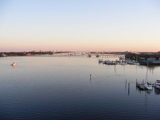 | |
| Volusia County's Halifax River was added to the IRL National Estuary in 2016. The 25 mile addition includes Bulow Creek, Tomoka River, and southward to Ponce de Leon Inlet. Halifax River Article | |
| WBID: | Type: Lagoon |
| Basin: Halifax River | County: Volusia |
Location: 29.25828,-81.03733
| |
Halifax River Tributaries
Tributaries are listed from North to South.
- Bulow Creek
- Tomoka River
- Fozzard Creek
- Wilbur Bay
- Rose Bay
- Mill Creek
- Spruce Creek
- Braddock Creek
- Hunter Creek
- Callalisa Creek
- Elwinder Creek
- Bottle Island Creek
| Mosquito Lagoon | |
|---|---|
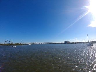 | |
| Mosquito Lagoon (Los Mosquitos) is a 28 mile long, 36,000 acre, brackish water lagoon bounded by Ponce de Leon Inlet, Merritt Island National Wildlife Refuge, Canaveral National Seashore and Kennedy Space Center (KSC). Mosquito Lagoon Article | |
| WBID: | Type: Lagoon |
| Basin: Mosquito Lagoon | County: Volusia |
Location: 28.83656,-80.79413
| |
Mosquito Lagoon Tributaries
Tributaries are listed from North to South.
| Banana River | |
|---|---|
 | |
| Lying entirely within Brevard County, 31 mile long, 30,000 acre Banana River is the smallest lagoon basin in the Indian River Lagoon National Estuary. Banana River Article | |
| WBID: 3057B | Type: Lagoon |
| Basin: Banana River | County: Brevard |
Location: 28.44858,-80.62544
| |
Banana River Tributaries
Tributaries are listed from North to South.
Brevard
- Banana Creek
- Canaveral Lock
- Canaveral Barge Canal
- Sykes Creek
- Grand Canal
- Indian River
| Indian River | |
|---|---|
 | |
| Indian River (Rio de Ais) is a 121 mile long lagoon spanning five counties on Florida's East Coast. From it's northern boundary in Brevard County, the lagoon ranges south through Indian River, St. Lucie and Martin, to it's southern boundary at Jupiter Inlet in Palm Beach County. Indian River is the largest lagoon basin in the Indian River Lagoon National Estuary. Indian River Article | |
| WBID: 2963B1 | Type: Lagoon |
| Basin: Indian River | County: Brevard |
Location: 28.15337,-80.62511
| |
Indian River Tributaries
Tributaries are listed from North to South.
Brevard County
- Turnbull Creek
- Haulover Canal
- Gator Creek
- Catfish Creek
- Banana Creek
- Canaveral Barge Canal
- Horse Creek
- Banana River
- Eau Gallie River
- Crane Creek
- Turkey Creek
- Goat Creek
- Kid Creek
- Trout Creek
- Mullet Creek
Indian River County
- Saint Sebastian River
- Sebastian Inlet
St. Lucie County
- Taylor Creek
- Fort Pierce Inlet
- Moores Creek
Martin County
- Saint Lucie River
- Saint Lucie Inlet
Palm Beach County
- Loxahatchee River
- Jupiter Inlet
Site Note:
*Normally a river's course is described in the direction of it's current flow. The Indian River Estuary doesn't have a directional flow, so this website will always describe it's Water Bodies in a north to south direction.
*Lagoons do not have a directional current and some water bodies (tidal marshes, canals and inlets) flow in both directions, so these water bodies are not technically tributaries. However, for this website's purposes, all connecting water bodies regardless of current, may be referred to as tributaries.
Web Links
References
Subcategories
This category has the following 5 subcategories, out of 5 total.