Info:Roosevelt Bridge: Difference between revisions
From Indian River Lagoon Project
|
|
| Line 18: |
Line 18: |
| |Posted=20191203234051 | | |Posted=20191203234051 |
| }} | | }} |
| {{Bridge_Data_Query|where=Number_008|like=890151}} | | <div class="irlcontentmiddle"> |
| {{Bridge_Data_Query|where=Number_008|like=890152}} | | Pineda Causeway contains six bridges: |
| | {| class="wikitable" |
| | ! style="text-align:left;"|Number |
| | ! Water |
| | ! Location |
| | ! Road |
| | |- colspan=4 |
| | |700142 |
| | |Indian River |
| | |Southbound Span |
| | |SR407 |
| | |- |
| | |colspan=4|{{Bridge_Data_Query|where=Number_008|like=890151}} |
| | |} |
| | |
| | {| class="wikitable" |
| | ! style="text-align:left;"|Number |
| | ! Water |
| | ! Location |
| | ! Road |
| | |- colspan=4 |
| | |700143 |
| | |Indian River |
| | |Northbound Span |
| | |SR407 |
| | |- |
| | |colspan=4|{{Bridge_Data_Query|where=Number_008|like=890152}} |
| | |} |
| | </div> |
Revision as of 12:38, November 19, 2020
Roosevelt Bridge
|
|
|
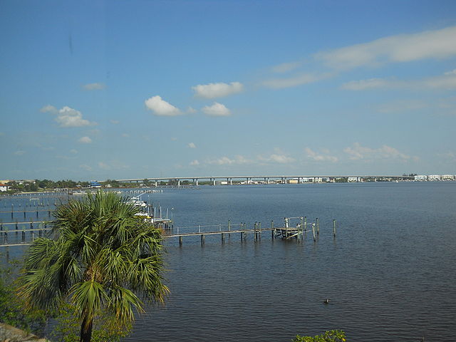
| The Roosevelt Bridge is a major highway segmental bridge across the St. Lucie River in Stuart, Florida. Carrying U.S. Route 1, it was built to supersede the old Roosevelt Bridge, which had twin parallel drawbridges, one for northbound traffic and the other for southbound.
|
| Waterway: Saint Lucie River
|
Road: US1
|
| City: Stuart
|
County: Martin
|
| Type: Segmental Span
|
Builder:Finley
|
| DOT: 890151, 890152
|
L: 2982.8'
|
H: 62.3'
|
Built: 1996
|
Location: 27.20672, -80.25854
|
Pineda Causeway contains six bridges:
| Number
|
Water
|
Location
|
Road
|
| 700142
|
Indian River
|
Southbound Span
|
SR407
|
National Bridge Data
| Number
|
890151
|
| Route
|
00001
|
| Place
|
Stuart
|
| County
|
Martin
|
| Features
|
St. Lucie River/SR-707
|
| Facility
|
SB US-1/SR-5
|
| Location
|
1mi S of SR-707 on SR-5
|
| Latitude
|
27121800
|
| Longitude
|
80153156
|
| Service On Roadway
|
Highway - Pedestrian
|
| Service Under Roadway
|
Highway-waterway-railroad
|
| Owner
|
FDOT
|
| Built
|
1997
|
| Rebuilt
|
|
| Lanes
|
3
|
| Lane Direction
|
1 way
|
| Direction
|
|
| Traffic
|
29914
|
| Traffic Year
|
2016
|
| Future Traffic
|
51900
|
| Future Traffic Year
|
2038
|
| Length
|
1368m
|
| Width
|
19m
|
| Clearance
|
|
| Kind
|
Prestressed concrete continuous
|
| Type
|
Segmental box girder
|
| Deck Type
|
Concrete Cast-in-Place
|
| Critical
|
|
| Inspection Date (mm-yy)
|
06-16
|
| Deck
|
Good
|
| Superstructure
|
Good
|
| Substructure
|
Good
|
| Channel
|
Bank protection is in need of minor repairs. River control devices and embankment protection have a little minor damage. Banks and/or channel have minor amounts of drift.
|
| Culvert
|
N/A
|
| Scour
|
Bridge foundations determined to be stable for the assessed or calculated scour condition. Scour is determined to be above top of footing (Example A) by assessment (i.e., bridge foundations are on rock formations that have been determined to resist scour within the service life of the bridge4), by calculation or by installation of properly designed countermeasures
|
|
| Number
|
Water
|
Location
|
Road
|
| 700143
|
Indian River
|
Northbound Span
|
SR407
|
National Bridge Data
| Number
|
890152
|
| Route
|
00001
|
| Place
|
Stuart
|
| County
|
Martin
|
| Features
|
St Lucie River / SR-707
|
| Facility
|
NB US-1 / SR-5
|
| Location
|
1mi S of SR-707 on SR-5
|
| Latitude
|
27120317
|
| Longitude
|
80152627
|
| Service On Roadway
|
Highway - Pedestrian
|
| Service Under Roadway
|
Highway-waterway-railroad
|
| Owner
|
FDOT
|
| Built
|
1997
|
| Rebuilt
|
|
| Lanes
|
3
|
| Lane Direction
|
1 way
|
| Direction
|
|
| Traffic
|
29914
|
| Traffic Year
|
2016
|
| Future Traffic
|
51900
|
| Future Traffic Year
|
2038
|
| Length
|
1391m
|
| Width
|
19m
|
| Clearance
|
|
| Kind
|
Prestressed concrete continuous
|
| Type
|
Segmental box girder
|
| Deck Type
|
Concrete Cast-in-Place
|
| Critical
|
|
| Inspection Date (mm-yy)
|
06-16
|
| Deck
|
N/A
|
| Superstructure
|
Good
|
| Substructure
|
Satisfactory
|
| Channel
|
N/A
|
| Culvert
|
N/A
|
| Scour
|
Bridge foundations determined to be stable for the assessed or calculated scour condition. Scour is determined to be above top of footing (Example A) by assessment (i.e., bridge foundations are on rock formations that have been determined to resist scour within the service life of the bridge4), by calculation or by installation of properly designed countermeasures
|
|
