Link:National Estuary Program Map: Difference between revisions
From Indian River Lagoon Project
mNo edit summary |
mNo edit summary |
||
| Line 2: | Line 2: | ||
|Name=National Estuary Program Map | |Name=National Estuary Program Map | ||
|Link Url=https://gispub2.epa.gov/NEPmap/index.html | |Link Url=https://gispub2.epa.gov/NEPmap/index.html | ||
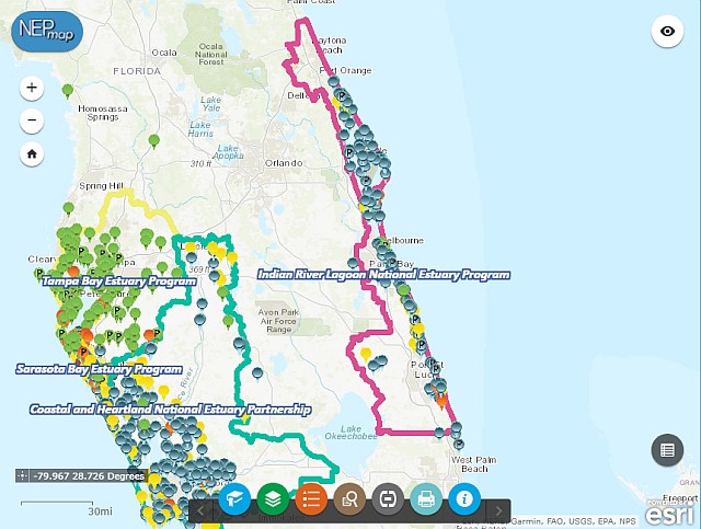
|Description=This interactive map from the EPA displays the National Estuaries and the ongoing and completed restoration projects. | |Description=This interactive map from the EPA displays the National Estuaries and the ongoing and completed restoration projects. Zoom into Indian River Estuary to see the projects in our area. | ||
Zoom into Indian River Estuary to see the projects in our area. | |||
|Type=Map | |Type=Map | ||
|Topic=Conservation | |Topic=Conservation | ||
| Line 10: | Line 8: | ||
|Screenshot=link-screenshot-national-estuary-program-map.jpg | |Screenshot=link-screenshot-national-estuary-program-map.jpg | ||
|Poster=Admin | |Poster=Admin | ||
| | |Posted=20191116110314 | ||
}} | }} | ||
[[Category:Web Link]] | [[Category:Web Link]] | ||
Revision as of 10:07, November 7, 2020
This interactive map from the EPA displays the National Estuaries and the ongoing and completed restoration projects. Zoom into Indian River Estuary to see the projects in our area.
Posted By: AdminPost Date: 2019-11-16