Canaveral National Seashore/Backcountry Camping: Difference between revisions
From Indian River Lagoon Project
mNo edit summary |
mNo edit summary |
||
| Line 3: | Line 3: | ||
<div class="irlcontenttop"> | <div class="irlcontenttop"> | ||
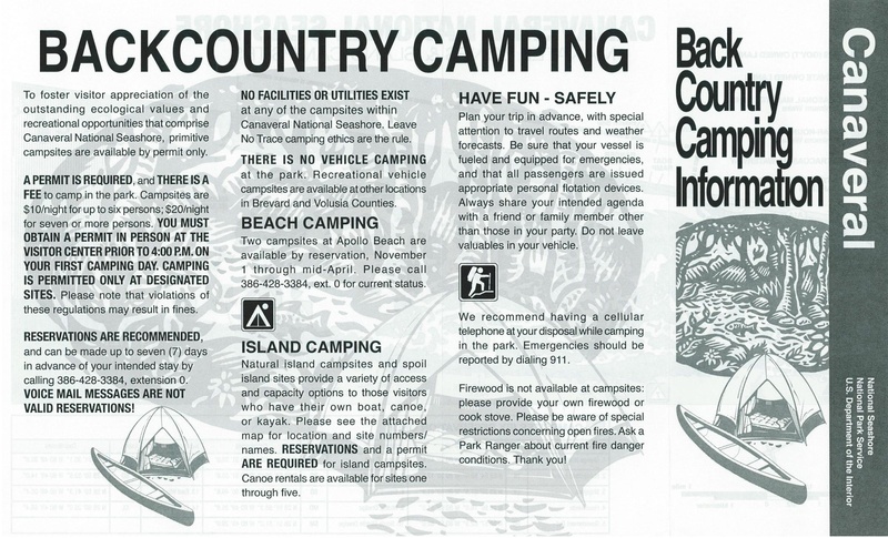
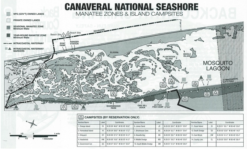
Canaveral National Seashore offers primitive backcountry island camping sites by permit only. This is a pdf file of an old brochure published by the National Park Service. Visit the [https://www.nps.gov/cana/index.htm Canaveral National Seashore Website] for current information and permitting. | Canaveral National Seashore offers primitive backcountry island camping sites by permit only. This is a pdf file of an old brochure published by the National Park Service. Visit the [https://www.nps.gov/cana/index.htm Canaveral National Seashore Website] for current information and permitting. | ||
</div> | </div> | ||
<div class="irlcontentmiddle"> | <div class="irlcontentmiddle"> | ||
[[File:Canaveral-national-seashore-backcountry-camping.pdf|800px|page=1]] | [[File:Canaveral-national-seashore-backcountry-camping.pdf|800px|page=1]] | ||
| Line 19: | Line 14: | ||
Download: [[:File:Canaveral-national-seashore-backcountry-camping.pdf|Canaveral National Seashore Backcountry Camping Brochure]] | Download: [[:File:Canaveral-national-seashore-backcountry-camping.pdf|Canaveral National Seashore Backcountry Camping Brochure]] | ||
</div> | </div> | ||
<div class="irlcontentmiddle"> | |||
{{#ev:youtube|DA_85oeOtuM|400px|left}} | |||
</div> | |||
<div class="irlcontentmiddle"> | <div class="irlcontentmiddle"> | ||
==Location== | ==Location== | ||
Map Coordinates= 28°55'29.5"N 80°50'01.1"W | Map Coordinates= 28°55'29.5"N 80°50'01.1"W | ||
{{#cargo_display_map:point=28.924858, -80.833634 |service=googlemaps|width=inherit|height= | {{#cargo_display_map:point=28.924858, -80.833634 |service=googlemaps|width=inherit|height=300px|zoom=14 |}} | ||
</div> | </div> | ||
{{IRL footer}} | {{IRL footer}} | ||
Revision as of 04:12, October 12, 2020
Canaveral National Seashore offers primitive backcountry island camping sites by permit only. This is a pdf file of an old brochure published by the National Park Service. Visit the Canaveral National Seashore Website for current information and permitting.
Location
Map Coordinates= 28°55'29.5"N 80°50'01.1"W