Merrill Barber Bridge: Difference between revisions
mNo edit summary |
mNo edit summary |
||
| (17 intermediate revisions by the same user not shown) | |||
| Line 1: | Line 1: | ||
<div class="irlbody"> | <div class="irlbody"> | ||
{{IRL header | {{IRL header estuary|cat=Bridges}} | ||
<div class="irlcontenttop"> | <div class="irlcontenttop"> | ||
<div class=" | <section begin=about /> | ||
= | Merrill P. Barber Bridge, built in 1995 by Odebrecht Contractors of Florida, Inc., is a concrete arch bridge that spans SR60 over the Indian River and Intracoastal Waterway in Indian River County, Florida. Merrill Barber bridge has a total length of 3,834 feet (1,169 m) with a main span of 100 feet (30 m) and a 65 ft vertical clearance. The Florida Department of Transportation number for this bridge is 880087. | ||
<div class=" | <section end=about /> | ||
</div> | |||
<div class="irlcontentmiddle> | |||
{{Bridge Query|like={{PAGENAME}}}} | |||
</div> | |||
<div class="irlcontentmiddle"> | |||
==History== | |||
[[File:Barber bridge.JPG|400px|frameless|right|alt=Merrill P. Barber Bridge (SR60)|Merrill P. Barber Bridge (SR60)]] | |||
The original connection to the barrier island was a curved wooden structure built on cabbage palm pilings and opened in 1920. | |||
In 1951, the wooden bridge was replaced with a concrete bridge with a steel bascule span. This bridge was in constant state of disrepair and was removed, barged out to sea and sunk as an artificial reef. | |||
The | The old steel bascule span was purchased by Disney and is now in Orlando at the Walt Disney World theme park. | ||
The bridge | The bridge is named for Merrill P. Barber, the mayor of Vero Beach from 1947 to 1949, and member of the Florida Senate from the 12th District from 1954 to 1958 and from the 29th District from 1963 to 1968. | ||
</div> | </div> | ||
<div class="irlcontentmiddle"> | <div class="irlcontentmiddle"> | ||
==Fact Sheet== | ==Fact Sheet== | ||
<p>Source: National Bridge Inventory. Information not verified; use at your own risk.</p> | <p>Source: National Bridge Inventory. Information not verified; use at your own risk.</p> | ||
| Line 56: | Line 43: | ||
<tr><td class="a">Deck type:</td><td>Concrete Cast-in-Place <var>[1]</var></td></tr> | <tr><td class="a">Deck type:</td><td>Concrete Cast-in-Place <var>[1]</var></td></tr> | ||
</table> | </table> | ||
</div> | |||
<div class="irlcontentmiddle"> | |||
< | <div class="irlvideo"> | ||
< | ==Video== | ||
{{#ev:youtube|https://www.youtube.com/watch?v=npy0vkKC65U|inherit|left}} | |||
</div> | </div> | ||
</div> | </div> | ||
| Line 82: | Line 56: | ||
* [https://bridgereports,com BridgeReports.com] | * [https://bridgereports,com BridgeReports.com] | ||
</div> | </div> | ||
{{IRL footer | {{IRL footer estuary|cat=Central Indian River Bridges}} | ||
</div> | </div> | ||
[[Category:Bridges]] | [[Category:Central Indian River Bridges]] | ||
[[Category:Indian River County]] | [[Category:Indian River County]] | ||
Latest revision as of 10:48, December 31, 2021
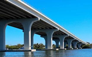
Merrill P. Barber Bridge, built in 1995 by Odebrecht Contractors of Florida, Inc., is a concrete arch bridge that spans SR60 over the Indian River and Intracoastal Waterway in Indian River County, Florida. Merrill Barber bridge has a total length of 3,834 feet (1,169 m) with a main span of 100 feet (30 m) and a 65 ft vertical clearance. The Florida Department of Transportation number for this bridge is 880087.
| Waterway: Central Indian River | Road: SR60 | |||
| City: Vero Beach | County: Indian River | |||
| Type: concrete arch | Builder:Odebrecht | |||
| DOT: 880087 | L: 3834' | H: 62' | Built: 1995-01-01 | |
Location: (27.65293,-80.37329)
Tap for active map.
| ||||
| The Merrill Barber Bridge is a concrete arch bridge that spans SR60 over the Indian River in Indian River County, Florida. | ||||
History
The original connection to the barrier island was a curved wooden structure built on cabbage palm pilings and opened in 1920.
In 1951, the wooden bridge was replaced with a concrete bridge with a steel bascule span. This bridge was in constant state of disrepair and was removed, barged out to sea and sunk as an artificial reef.
The old steel bascule span was purchased by Disney and is now in Orlando at the Walt Disney World theme park.
The bridge is named for Merrill P. Barber, the mayor of Vero Beach from 1947 to 1949, and member of the Florida Senate from the 12th District from 1954 to 1958 and from the 29th District from 1963 to 1968.
Fact Sheet
Source: National Bridge Inventory. Information not verified; use at your own risk.
| Name: | SR-60 over ICWW |
| Structure number: | 880087 |
| Location: | 0.6Mi. W of SR-A1A |
| Purpose: | Carries highway and pedestrian walkway over waterway |
| Route classification: | Minor Arterial (Urban) [16] |
| Length of largest span: | 142.1 ft. [43.3 m] |
| Total length: | 3834.2 ft. [1168.6 m] |
| Roadway width between curbs: | 80.1 ft. [24.4 m] |
| Deck width edge-to-edge: | 99.1 ft. [30.2 m] |
| Vertical clearance below bridge: | 62.3 ft. [19.0 m] |
| Owner: | State Highway Agency [01] |
| Year built: | 1995 |
| Historic significance: | Bridge is not eligible for the National Register of Historic Places [5] |
| Design load: | MS 18+Mod / HS 20+Mod [6] |
| Number of main spans: | 27 |
| Main spans material: | Prestressed concrete continuous [6] |
| Main spans design: | Stringer/Multi-beam or girder [02] |
| Deck type: | Concrete Cast-in-Place [1] |


